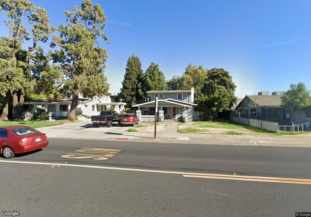
737 W F St Oakdale, CA 95361
Estimated Value: $415,000 - $447,000
3
Beds
2
Baths
1,511
Sq Ft
$283/Sq Ft
Est. Value
About This Home
This home is located at 737 W F St, Oakdale, CA 95361 and is currently estimated at $427,917, approximately $283 per square foot. 737 W F St is a home located in Stanislaus County with nearby schools including Fair Oaks Elementary School, Oakdale Junior High School, and East Stanislaus High School.
Ownership History
Date
Name
Owned For
Owner Type
Purchase Details
Closed on
Oct 28, 2021
Sold by
Stallings Douglas Wayne
Bought by
Medlen Stephen Don and Medlen Douglas Wayne
Current Estimated Value
Purchase Details
Closed on
Oct 19, 2012
Sold by
Stallings Mary K and Stallings Family Trust
Bought by
Stallings Douglas Wayne
Purchase Details
Closed on
Apr 15, 2011
Sold by
Stallings Jack and Stallings Douglas Wayne
Bought by
Stallings Jack and Stallings Douglas Wayne
Purchase Details
Closed on
Sep 9, 2010
Sold by
Stallings Hazel M
Bought by
Stallings Hazel Mae and Hazel Mae Stallings Revocable
Create a Home Valuation Report for This Property
The Home Valuation Report is an in-depth analysis detailing your home's value as well as a comparison with similar homes in the area
Home Values in the Area
Average Home Value in this Area
Purchase History
| Date | Buyer | Sale Price | Title Company |
|---|---|---|---|
| Medlen Stephen Don | -- | None Available | |
| Stallings Douglas Wayne | -- | None Available | |
| Stallings Jack | -- | None Available | |
| Stallings Jack | -- | None Available | |
| Stallings Hazel Mae | -- | None Available |
Source: Public Records
Tax History Compared to Growth
Tax History
| Year | Tax Paid | Tax Assessment Tax Assessment Total Assessment is a certain percentage of the fair market value that is determined by local assessors to be the total taxable value of land and additions on the property. | Land | Improvement |
|---|---|---|---|---|
| 2025 | $1,475 | $139,143 | $51,704 | $87,439 |
| 2024 | $1,397 | $136,416 | $50,691 | $85,725 |
| 2023 | $1,366 | $133,743 | $49,698 | $84,045 |
| 2022 | $1,341 | $131,122 | $48,724 | $82,398 |
| 2021 | $1,318 | $128,552 | $47,769 | $80,783 |
| 2020 | $1,303 | $127,235 | $47,280 | $79,955 |
| 2019 | $1,281 | $124,741 | $46,353 | $78,388 |
| 2018 | $1,262 | $122,296 | $45,445 | $76,851 |
| 2017 | $1,239 | $119,899 | $44,554 | $75,345 |
| 2016 | $1,216 | $117,549 | $43,681 | $73,868 |
| 2015 | $445 | $47,368 | $23,006 | $24,362 |
| 2014 | $440 | $46,441 | $22,556 | $23,885 |
Source: Public Records
Map
Nearby Homes
- 24 N Bryan Ave
- 140 Blankenship Ave
- 64 School Ave
- 1105 W G St
- 147 West Ave
- 166 Stanislaus Ave
- 325 W H St
- 262 California 108
- 1342 Pontiac St
- 209 N 1st Ave
- 886 Ranchland Way
- 219 S 2nd Ave
- 429 Ranger Ct Unit 111
- 151 S 3rd Ave
- 161 S 3rd Ave
- 901 Meadowlands Dr
- 980 Silver Spur Cir Unit 41
- 1625 Valmor Ct
- 968 Greger St Unit 91
- 557 Stetson Dr