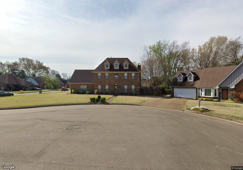
7405 Katie Cove Memphis, TN 38125
Southern Shelby County NeighborhoodEstimated Value: $286,000 - $331,000
4
Beds
3
Baths
2,886
Sq Ft
$107/Sq Ft
Est. Value
About This Home
This home is located at 7405 Katie Cove, Memphis, TN 38125 and is currently estimated at $307,871, approximately $106 per square foot. 7405 Katie Cove is a home located in Shelby County with nearby schools including Highland Oaks Elementary School, Highland Oaks Middle School, and Southwind High School.
Ownership History
Date
Name
Owned For
Owner Type
Purchase Details
Closed on
Mar 25, 2004
Sold by
Nathaniel Judith D
Bought by
Sanders Darrell and Sanders Julia R
Current Estimated Value
Home Financials for this Owner
Home Financials are based on the most recent Mortgage that was taken out on this home.
Original Mortgage
$154,000
Outstanding Balance
$71,317
Interest Rate
5.54%
Mortgage Type
FHA
Estimated Equity
$236,554
Purchase Details
Closed on
Jun 29, 2001
Sold by
Mcdougall Donald R and Mcdougall Mary C
Bought by
Nathaniel Judith D
Home Financials for this Owner
Home Financials are based on the most recent Mortgage that was taken out on this home.
Original Mortgage
$153,589
Interest Rate
7.23%
Mortgage Type
FHA
Purchase Details
Closed on
Sep 20, 1995
Bought by
Keith Watts D and Keith Michele L
Create a Home Valuation Report for This Property
The Home Valuation Report is an in-depth analysis detailing your home's value as well as a comparison with similar homes in the area
Home Values in the Area
Average Home Value in this Area
Purchase History
| Date | Buyer | Sale Price | Title Company |
|---|---|---|---|
| Sanders Darrell | $169,900 | -- | |
| Nathaniel Judith D | $156,000 | -- | |
| Keith Watts D | $129,000 | -- |
Source: Public Records
Mortgage History
| Date | Status | Borrower | Loan Amount |
|---|---|---|---|
| Open | Sanders Darrell | $154,000 | |
| Previous Owner | Nathaniel Judith D | $153,589 |
Source: Public Records
Tax History Compared to Growth
Tax History
| Year | Tax Paid | Tax Assessment Tax Assessment Total Assessment is a certain percentage of the fair market value that is determined by local assessors to be the total taxable value of land and additions on the property. | Land | Improvement |
|---|---|---|---|---|
| 2025 | $1,724 | $66,200 | $14,250 | $51,950 |
| 2024 | $1,724 | $50,850 | $8,425 | $42,425 |
| 2023 | $1,724 | $50,850 | $8,425 | $42,425 |
| 2022 | $1,724 | $50,850 | $8,425 | $42,425 |
| 2021 | $1,754 | $50,850 | $8,425 | $42,425 |
| 2020 | $1,478 | $36,500 | $8,425 | $28,075 |
| 2019 | $1,478 | $36,500 | $8,425 | $28,075 |
| 2018 | $1,478 | $36,500 | $8,425 | $28,075 |
| 2017 | $1,500 | $36,500 | $8,425 | $28,075 |
| 2016 | $1,444 | $33,050 | $0 | $0 |
| 2014 | $1,444 | $33,050 | $0 | $0 |
Source: Public Records
Map
Nearby Homes
- 4820 Harvest Knoll Ln
- 4764 Buttermilk Dr
- 4735 Harvest Knoll Cove N
- 7522 Starfire Cove
- 7352 Red River Cove
- 4768 Gertrude Dr
- 4768 Bradfield Run
- 4927 Bradfield Run
- 4826 Callaway Hills Dr
- 7473 Kylan Dr
- 7321 Stonington Dr
- 5100 Sunny Autumn Ln
- 4569 Cardiff Cove
- 7125 Farmhouse Dr
- 5084 Autumn Morning Ln
- 4512 S Germantown Rd
- 7286 New Britain Dr
- 5265 Annandale Dr
- 5178 Autumn Morning Cove
- 7421 Richmond Rd
- 7406 Heather Knoll Cove
- 7401 Katie Cove
- 7400 Heather Knoll Cove
- 4856 Harvest Fields Cir
- 4868 Harvest Fields Cir
- 7402 Katie Cove
- 4850 Harvest Fields Cir
- 7408 Katie Cove
- 4872 Harvest Fields Cir
- 7398 Heather Knoll Cove
- 4844 Harvest Fields Cir
- 4858 Harvest Knoll Ln
- 4866 Harvest Knoll Ln
- 4848 Harvest Knoll Ln
- 4874 Harvest Knoll Ln
- 4838 Harvest Knoll Ln
- 4865 Bronze Dr
- 4882 Harvest Fields Cir
- 4829 Harvest Fields Cir
- 7407 Heather Knoll Cove