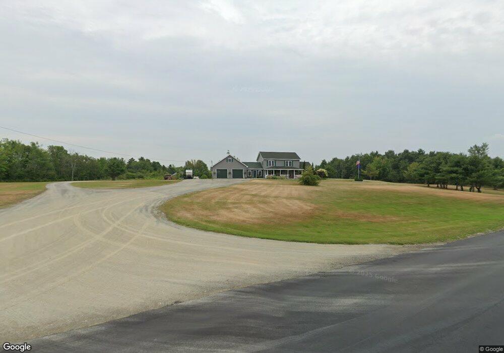
741 Stetson Rd Newport, ME 04953
Estimated Value: $450,000 - $589,000
4
Beds
3
Baths
2,680
Sq Ft
$200/Sq Ft
Est. Value
About This Home
This home is located at 741 Stetson Rd, Newport, ME 04953 and is currently estimated at $534,938, approximately $199 per square foot. 741 Stetson Rd is a home located in Penobscot County with nearby schools including Sebasticook Valley Elementary School and Nokomis Regional Middle School/High School.
Ownership History
Date
Name
Owned For
Owner Type
Purchase Details
Closed on
Jan 22, 2016
Sold by
Beland Kenneth F and Burk Judy A
Bought by
Charters Jeffrey T and Charters Stephanie L
Current Estimated Value
Home Financials for this Owner
Home Financials are based on the most recent Mortgage that was taken out on this home.
Original Mortgage
$210,000
Outstanding Balance
$128,977
Interest Rate
3.98%
Mortgage Type
New Conventional
Estimated Equity
$405,961
Purchase Details
Closed on
May 23, 2008
Sold by
Seeds James
Bought by
Charters Jeffrey T and Charters Stephanie L
Create a Home Valuation Report for This Property
The Home Valuation Report is an in-depth analysis detailing your home's value as well as a comparison with similar homes in the area
Home Values in the Area
Average Home Value in this Area
Purchase History
| Date | Buyer | Sale Price | Title Company |
|---|---|---|---|
| Charters Jeffrey T | -- | -- | |
| Charters Jeffrey T | -- | -- |
Source: Public Records
Mortgage History
| Date | Status | Borrower | Loan Amount |
|---|---|---|---|
| Open | Charters Jeffrey T | $210,000 | |
| Previous Owner | Charters Jeffrey T | $10,000 | |
| Previous Owner | Charters Jeffrey T | $184,000 |
Source: Public Records
Tax History Compared to Growth
Tax History
| Year | Tax Paid | Tax Assessment Tax Assessment Total Assessment is a certain percentage of the fair market value that is determined by local assessors to be the total taxable value of land and additions on the property. | Land | Improvement |
|---|---|---|---|---|
| 2024 | $5,789 | $330,800 | $55,000 | $275,800 |
| 2023 | $5,040 | $309,200 | $51,400 | $257,800 |
| 2022 | $4,790 | $244,400 | $40,700 | $203,700 |
| 2021 | $4,812 | $233,600 | $38,900 | $194,700 |
| 2020 | $4,722 | $229,200 | $38,100 | $191,100 |
| 2019 | $4,607 | $216,300 | $36,000 | $180,300 |
| 2018 | $4,607 | $216,300 | $36,000 | $180,300 |
| 2017 | $4,326 | $216,300 | $36,000 | $180,300 |
| 2016 | $4,196 | $216,300 | $36,000 | $180,300 |
| 2015 | $3,700 | $206,700 | $26,400 | $180,300 |
| 2014 | $3,590 | $208,700 | $26,400 | $182,300 |
Source: Public Records
Map
Nearby Homes
- 590 Stetson Rd
- 53 Burleigh Rd
- 39 Burleigh Rd
- 291 Lakins Rd
- 80 Jordon Rd
- 1407 Stage Rd
- Map7Lot71 Rt 2 Stage Rd
- 63 Grandview Dr
- 62 Cobb Rd
- 30 Grand View Dr
- Lot 3-12 Shady Ln
- 106 Shady Ln
- 35 Drew Ln
- 300 W Etna Rd
- 107 Shady Ln
- 53 Village Rd
- 156 Old Bangor Rd
- 965 Mount Pleasant Rd
- 91 Curtis Rd
- 133 Hart St
- 728 Stetson
- 0 E Newport Rd
- 749 Stetson Rd
- 684 Stetson Rd
- 670 Stetson Rd
- 642 Stetson Rd
- 383 E Newport
- 625 Stetson Rd
- 626 Stetson Rd
- 614 Stetson Rd
- 608 Stetson Rd
- 00 E Newport Rd
- 1607 E Newport Rd
- 602 E Newport Rd
- 1606 E Newport Rd
- 601 Stetson Rd
- 376 E Newport Rd
- 585 Stetson Rd
- 378 E Newport Rd
- Lot 2 Burliegh