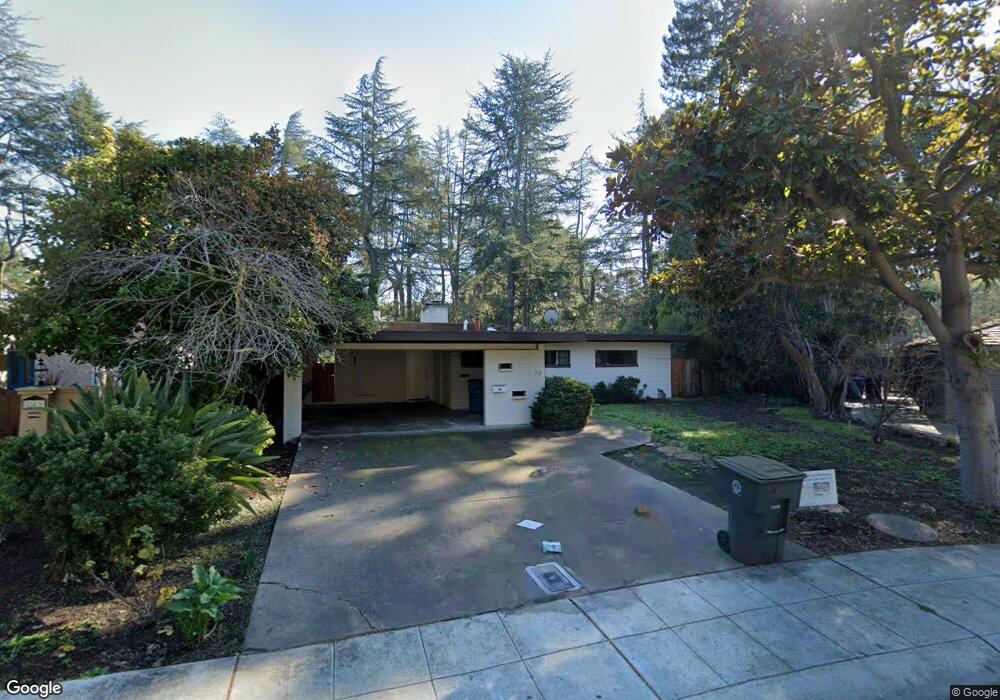
742 Southampton Dr Palo Alto, CA 94303
Old Palo Alto NeighborhoodEstimated Value: $4,733,000 - $5,370,000
3
Beds
2
Baths
1,979
Sq Ft
$2,486/Sq Ft
Est. Value
About This Home
This home is located at 742 Southampton Dr, Palo Alto, CA 94303 and is currently estimated at $4,918,891, approximately $2,485 per square foot. 742 Southampton Dr is a home located in Santa Clara County with nearby schools including Walter Hays Elementary, Frank S. Greene Jr. Middle, and Palo Alto High School.
Ownership History
Date
Name
Owned For
Owner Type
Purchase Details
Closed on
Apr 8, 2019
Sold by
Arce Laura Patricia Meneses
Bought by
Shih Klngstone C
Current Estimated Value
Purchase Details
Closed on
Apr 4, 2019
Sold by
Shih Kingstone C and Shih Joy L
Bought by
Agrawal Parag and Agrawal Vineeta
Purchase Details
Closed on
Jan 5, 2012
Sold by
Ching Shih Ke and Wei Lin Ho
Bought by
Shih Kingstone C and Shih Joy L
Create a Home Valuation Report for This Property
The Home Valuation Report is an in-depth analysis detailing your home's value as well as a comparison with similar homes in the area
Home Values in the Area
Average Home Value in this Area
Purchase History
| Date | Buyer | Sale Price | Title Company |
|---|---|---|---|
| Shih Klngstone C | -- | Old Republic Title Company | |
| Agrawal Parag | $3,912,500 | First American Title Company | |
| Shih Kingstone C | -- | None Available |
Source: Public Records
Tax History Compared to Growth
Tax History
| Year | Tax Paid | Tax Assessment Tax Assessment Total Assessment is a certain percentage of the fair market value that is determined by local assessors to be the total taxable value of land and additions on the property. | Land | Improvement |
|---|---|---|---|---|
| 2025 | $46,913 | $4,238,971 | $4,238,971 | -- |
| 2024 | $46,913 | $3,900,000 | $3,785,000 | $115,000 |
| 2023 | $44,116 | $3,645,000 | $3,540,100 | $104,900 |
| 2022 | $50,534 | $4,112,734 | $3,994,478 | $118,256 |
| 2021 | $48,956 | $4,032,093 | $3,916,155 | $115,938 |
| 2020 | $47,933 | $3,990,750 | $3,876,000 | $114,750 |
| 2019 | $11,446 | $891,581 | $605,607 | $285,974 |
| 2018 | $11,144 | $874,100 | $593,733 | $280,367 |
| 2017 | $10,946 | $856,962 | $582,092 | $274,870 |
| 2016 | $10,654 | $840,160 | $570,679 | $269,481 |
| 2015 | $10,545 | $827,541 | $562,107 | $265,434 |
| 2014 | $10,268 | $811,332 | $551,097 | $260,235 |
Source: Public Records
Map
Nearby Homes
- 627 Tennyson Ave
- 1827 Cowper St
- 836 Warren Way
- 1711 Guinda St
- 1730 Webster St
- 444 Tennyson Ave
- 2590 Webster St
- 1826 Waverley St
- 61 Primrose Way
- 2760 Byron St
- 915 Colonial Ln
- 1119 Hopkins Ave
- 1932 Emerson St
- 161 Primrose Way
- 184 Tennyson Ave
- 151 Colorado Ave
- 2200 Saint Francis Dr
- 1480 Bryant St
- 1037 Amarillo Ave
- 2573 Park Blvd Unit U204
- 748 Southampton Dr
- 736 Southampton Dr
- 754 Southampton Dr
- 743 Southampton Dr
- 730 Southampton Dr
- 762 Southampton Dr
- 751 Southampton Dr
- 703 N California Ave
- 2121 Middlefield Rd
- 2111 Middlefield Rd
- 761 Southampton Dr
- 722 Southampton Dr
- 772 Southampton Dr
- 2101 Middlefield Rd
- 723 Southampton Dr
- 2091 Middlefield Rd
- 771 Southampton Dr
- 782 Southampton Dr
- 710 Portal Place
- 2071 Middlefield Rd