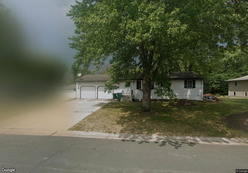
745 Lasso Ln Saint Paul, MN 55123
Estimated Value: $300,000 - $355,100
3
Beds
2
Baths
1,008
Sq Ft
$329/Sq Ft
Est. Value
About This Home
This home is located at 745 Lasso Ln, Saint Paul, MN 55123 and is currently estimated at $331,275, approximately $328 per square foot. 745 Lasso Ln is a home located in Dakota County with nearby schools including Pinewood Elementary School, Dakota Hills Middle School, and Eagan Senior High School.
Ownership History
Date
Name
Owned For
Owner Type
Purchase Details
Closed on
Mar 25, 2019
Sold by
Holzschuh Robert John
Bought by
Kemp Joseph N
Current Estimated Value
Home Financials for this Owner
Home Financials are based on the most recent Mortgage that was taken out on this home.
Original Mortgage
$232,800
Outstanding Balance
$204,254
Interest Rate
4.3%
Mortgage Type
New Conventional
Estimated Equity
$127,021
Create a Home Valuation Report for This Property
The Home Valuation Report is an in-depth analysis detailing your home's value as well as a comparison with similar homes in the area
Home Values in the Area
Average Home Value in this Area
Purchase History
| Date | Buyer | Sale Price | Title Company |
|---|---|---|---|
| Kemp Joseph N | $240,000 | Edina Realty Title Inc |
Source: Public Records
Mortgage History
| Date | Status | Borrower | Loan Amount |
|---|---|---|---|
| Open | Kemp Joseph N | $232,800 |
Source: Public Records
Tax History Compared to Growth
Tax History
| Year | Tax Paid | Tax Assessment Tax Assessment Total Assessment is a certain percentage of the fair market value that is determined by local assessors to be the total taxable value of land and additions on the property. | Land | Improvement |
|---|---|---|---|---|
| 2024 | $3,046 | $303,800 | $90,600 | $213,200 |
| 2023 | $3,046 | $288,700 | $90,800 | $197,900 |
| 2022 | $2,704 | $286,500 | $90,600 | $195,900 |
| 2021 | $2,620 | $251,100 | $78,800 | $172,300 |
| 2020 | $2,480 | $238,700 | $75,000 | $163,700 |
| 2019 | $2,283 | $221,500 | $71,400 | $150,100 |
| 2018 | $2,205 | $216,500 | $68,000 | $148,500 |
| 2017 | $2,141 | $204,000 | $64,800 | $139,200 |
| 2016 | $2,137 | $190,800 | $61,700 | $129,100 |
| 2015 | $1,953 | $168,879 | $55,102 | $113,777 |
| 2014 | -- | $156,562 | $52,833 | $103,729 |
| 2013 | -- | $150,131 | $47,598 | $102,533 |
Source: Public Records
Map
Nearby Homes
- 699 Calvin Ct
- 4358 Yorktown Dr
- 4231 Yorktown Dr
- 591 Autumn Oaks Ct
- 782 Summerbrooke Ct
- 681 Summer Ln
- 790 Summerbrooke Ct
- 4274 Maclaren Place
- 4080 Camberwell Dr N
- 4125 Pennsylvania Ave
- 4240 Braddock Trail
- 4072 Prairie Ridge Rd
- 4027 Camberwell Dr N
- 4162 Pennsylvania Ave
- 4001 Haven Woods Ct
- 4124 New York Ave
- 3998 Haven Woods Ct
- 4525 Alicia Dr
- 711 Stonebridge Cir
- 785 Canter Glen Cir