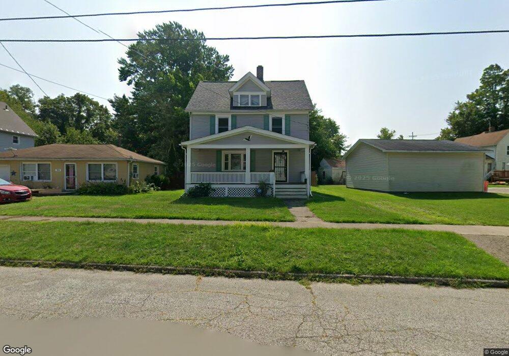
745 Maple Ave Conneaut, OH 44030
Estimated Value: $72,000 - $99,000
4
Beds
2
Baths
1,352
Sq Ft
$65/Sq Ft
Est. Value
About This Home
This home is located at 745 Maple Ave, Conneaut, OH 44030 and is currently estimated at $87,998, approximately $65 per square foot. 745 Maple Ave is a home located in Ashtabula County with nearby schools including Lakeshore Primary Elementary School, Gateway Elementary School, and Conneaut Middle School.
Ownership History
Date
Name
Owned For
Owner Type
Purchase Details
Closed on
Jan 15, 2019
Sold by
Hargett Rashel D
Bought by
Maunus Nicole L
Current Estimated Value
Purchase Details
Closed on
Jun 1, 2011
Sold by
Estate Of Linda M Lockwood
Bought by
Hargett Rashel D
Purchase Details
Closed on
Sep 5, 2008
Sold by
Lockwood Howard W
Bought by
Lockwood Linda M
Purchase Details
Closed on
Aug 19, 1996
Sold by
Heinonen Mark W
Bought by
Lockwood Howard W and Lockwood Linda M
Home Financials for this Owner
Home Financials are based on the most recent Mortgage that was taken out on this home.
Original Mortgage
$62,650
Interest Rate
8.18%
Mortgage Type
New Conventional
Create a Home Valuation Report for This Property
The Home Valuation Report is an in-depth analysis detailing your home's value as well as a comparison with similar homes in the area
Home Values in the Area
Average Home Value in this Area
Purchase History
| Date | Buyer | Sale Price | Title Company |
|---|---|---|---|
| Maunus Nicole L | $17,100 | Chicago Title Company | |
| Hargett Rashel D | -- | Attorney | |
| Lockwood Linda M | -- | Attorney | |
| Lockwood Howard W | $60,500 | -- |
Source: Public Records
Mortgage History
| Date | Status | Borrower | Loan Amount |
|---|---|---|---|
| Previous Owner | Lockwood Howard W | $62,650 |
Source: Public Records
Tax History Compared to Growth
Tax History
| Year | Tax Paid | Tax Assessment Tax Assessment Total Assessment is a certain percentage of the fair market value that is determined by local assessors to be the total taxable value of land and additions on the property. | Land | Improvement |
|---|---|---|---|---|
| 2024 | $1,058 | $14,460 | $2,770 | $11,690 |
| 2023 | $678 | $14,460 | $2,770 | $11,690 |
| 2022 | $594 | $11,140 | $2,140 | $9,000 |
| 2021 | $604 | $11,140 | $2,140 | $9,000 |
| 2020 | $604 | $11,140 | $2,140 | $9,000 |
| 2019 | $660 | $11,970 | $1,470 | $10,500 |
| 2018 | $629 | $11,970 | $1,470 | $10,500 |
| 2017 | $628 | $11,970 | $1,470 | $10,500 |
| 2016 | $836 | $17,470 | $2,140 | $15,330 |
| 2015 | $1,838 | $17,470 | $2,140 | $15,330 |
| 2014 | $2,630 | $17,470 | $2,140 | $15,330 |
| 2013 | $1,627 | $19,050 | $2,000 | $17,050 |
Source: Public Records
Map
Nearby Homes
- 247 Whitney St
- 589 Main St
- 855 Spring St Unit S9
- 536 Madison St
- 455 Main St
- 474 Sherman St
- 251 St Rt 7
- 18 Hillcrest Ct
- 429 Depot St
- 459 Mill St
- 405 Bliss Ave
- 0 Chestnut St Unit 5120761
- 375 Bliss Ave
- 536 Mill St
- 402 Broad St
- 408 Broad State Rd 7 St
- 289 Harbor St
- 210 W Main Rd
- 386 Washington St
- 202 W Main Rd Unit 49