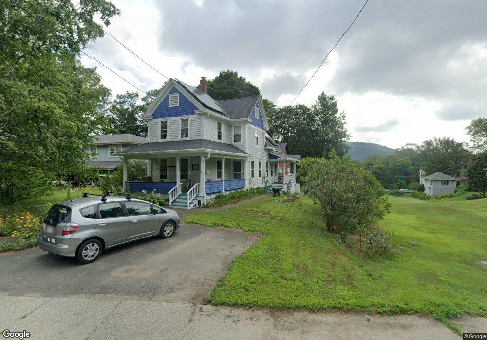
75 Ashfield St Shelburne Falls, MA 01370
Buckland NeighborhoodEstimated Value: $243,000 - $315,798
2
Beds
2
Baths
1,135
Sq Ft
$254/Sq Ft
Est. Value
About This Home
This home is located at 75 Ashfield St, Shelburne Falls, MA 01370 and is currently estimated at $288,200, approximately $253 per square foot. 75 Ashfield St is a home with nearby schools including Mohawk Trail Regional High School.
Ownership History
Date
Name
Owned For
Owner Type
Purchase Details
Closed on
Nov 17, 2009
Sold by
Williams Russell S
Bought by
Herzig James D and Herzig Megan A
Current Estimated Value
Home Financials for this Owner
Home Financials are based on the most recent Mortgage that was taken out on this home.
Original Mortgage
$152,950
Outstanding Balance
$99,768
Interest Rate
4.98%
Mortgage Type
Purchase Money Mortgage
Estimated Equity
$188,432
Purchase Details
Closed on
Jun 21, 2004
Sold by
Williams Francis R
Bought by
Williams Russell S
Purchase Details
Closed on
Jul 8, 1987
Sold by
Stafford Iris L
Bought by
Alpert Sharin G
Home Financials for this Owner
Home Financials are based on the most recent Mortgage that was taken out on this home.
Original Mortgage
$68,900
Interest Rate
10.71%
Mortgage Type
Purchase Money Mortgage
Create a Home Valuation Report for This Property
The Home Valuation Report is an in-depth analysis detailing your home's value as well as a comparison with similar homes in the area
Home Values in the Area
Average Home Value in this Area
Purchase History
| Date | Buyer | Sale Price | Title Company |
|---|---|---|---|
| Herzig James D | $161,000 | -- | |
| Williams Russell S | -- | -- | |
| Alpert Sharin G | $79,900 | -- |
Source: Public Records
Mortgage History
| Date | Status | Borrower | Loan Amount |
|---|---|---|---|
| Open | Herzig James D | $152,950 | |
| Closed | Alpert Sharin G | $8,000 | |
| Previous Owner | Alpert Sharin G | $68,900 |
Source: Public Records
Tax History Compared to Growth
Tax History
| Year | Tax Paid | Tax Assessment Tax Assessment Total Assessment is a certain percentage of the fair market value that is determined by local assessors to be the total taxable value of land and additions on the property. | Land | Improvement |
|---|---|---|---|---|
| 2025 | $4,199 | $247,900 | $55,500 | $192,400 |
| 2024 | $4,123 | $234,800 | $55,500 | $179,300 |
| 2023 | $3,651 | $215,500 | $55,500 | $160,000 |
| 2022 | $3,616 | $215,500 | $55,500 | $160,000 |
| 2021 | $3,454 | $193,600 | $55,500 | $138,100 |
| 2020 | $3,337 | $180,200 | $55,500 | $124,700 |
| 2019 | $3,154 | $169,300 | $55,500 | $113,800 |
| 2018 | $3,091 | $164,000 | $55,500 | $108,500 |
| 2017 | $2,960 | $164,000 | $55,500 | $108,500 |
| 2016 | $2,782 | $164,600 | $55,500 | $109,100 |
| 2015 | $2,765 | $164,600 | $55,500 | $109,100 |
Source: Public Records
Map
Nearby Homes
- 10 Deerfield Ave Unit 5
- 10 Deerfield Ave Unit 2
- 33 Williams St
- 105 - 107 Bridge St
- 102 Elm St
- 2151 Route 2
- 2155 Massachusetts 2
- 7 Hog Hollow Rd
- 156 Ashfield Rd
- 0 Upper St
- 31 W Oxbow Rd
- 24 W Oxbow Rd
- 0 W Oxbow Rd Unit 73453651
- 0 Ashfield Rd
- 3+5 Church St
- 143 Charlemont Rd
- 85 Dacey Rd
- lot 1 Shelburne Falls Rd
- 240 Beldingville Rd
- 0 Fiske Mill Rd