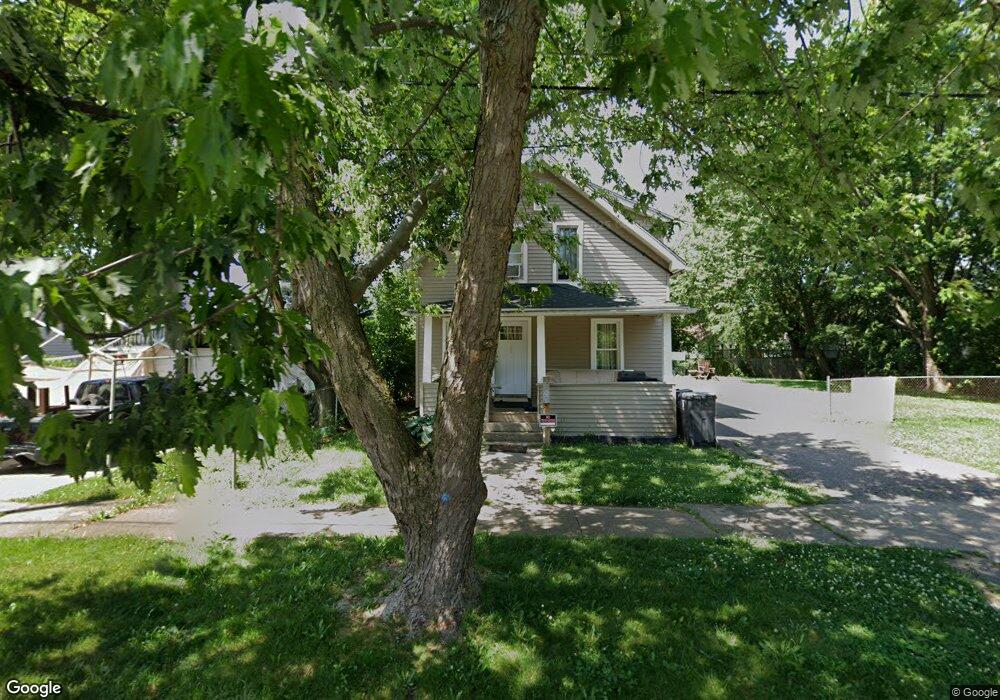
750 SiMcOe Ave Flint, MI 48507
South Side NeighborhoodEstimated Value: $40,000 - $57,072
3
Beds
2
Baths
1,127
Sq Ft
$43/Sq Ft
Est. Value
About This Home
This home is located at 750 SiMcOe Ave, Flint, MI 48507 and is currently estimated at $48,518, approximately $43 per square foot. 750 SiMcOe Ave is a home located in Genesee County with nearby schools including Eisenhower School, Flint Southwestern Classical Academy, and International Academy of Flint (K-12).
Ownership History
Date
Name
Owned For
Owner Type
Purchase Details
Closed on
Jan 11, 2019
Sold by
Klaffer Nathan D
Bought by
Kaffer Joann
Current Estimated Value
Purchase Details
Closed on
Jun 27, 2016
Sold by
Klaffer Dewayne
Bought by
Klaffer Nathan
Purchase Details
Closed on
Sep 13, 2012
Sold by
Taylor Katrina
Bought by
Klaffer Dewayne
Purchase Details
Closed on
Apr 26, 2012
Sold by
Griggs Kendra
Bought by
Taylor Katrina
Purchase Details
Closed on
Dec 16, 2009
Sold by
Donovan Shaun and Secretary Of Housing & Urban D
Bought by
Griggs Kendra
Purchase Details
Closed on
Jan 19, 2007
Sold by
Washington Mutual Bank
Bought by
Hud
Purchase Details
Closed on
Jul 12, 2006
Sold by
Regits Bobbie L
Bought by
Washington Mutual Bank
Purchase Details
Closed on
Aug 25, 2000
Sold by
Bird K L
Bought by
Regits Bobbie L
Create a Home Valuation Report for This Property
The Home Valuation Report is an in-depth analysis detailing your home's value as well as a comparison with similar homes in the area
Home Values in the Area
Average Home Value in this Area
Purchase History
| Date | Buyer | Sale Price | Title Company |
|---|---|---|---|
| Kaffer Joann | -- | None Available | |
| Klaffer Nathan | -- | Attorney | |
| Klaffer Dewayne | -- | None Available | |
| Taylor Katrina | -- | None Available | |
| Griggs Kendra | $1,000 | None Available | |
| Hud | -- | None Available | |
| Washington Mutual Bank | $57,578 | None Available | |
| Regits Bobbie L | $40,541 | Metropolitan Title Company |
Source: Public Records
Tax History
| Year | Tax Paid | Tax Assessment Tax Assessment Total Assessment is a certain percentage of the fair market value that is determined by local assessors to be the total taxable value of land and additions on the property. | Land | Improvement |
|---|---|---|---|---|
| 2025 | $785 | $19,900 | $0 | $0 |
| 2024 | $718 | $21,400 | $0 | $0 |
| 2023 | $710 | $20,200 | $0 | $0 |
| 2022 | $0 | $15,400 | $0 | $0 |
| 2021 | $733 | $10,600 | $0 | $0 |
| 2020 | $668 | $12,600 | $0 | $0 |
| 2019 | $1,173 | $8,300 | $0 | $0 |
| 2018 | $2,854 | $8,300 | $0 | $0 |
| 2017 | $1,291 | $0 | $0 | $0 |
| 2016 | $881 | $0 | $0 | $0 |
| 2015 | -- | $0 | $0 | $0 |
| 2014 | -- | $0 | $0 | $0 |
| 2012 | -- | $13,000 | $0 | $0 |
Source: Public Records
Map
Nearby Homes
- 741 Barrie Ave
- 839 Barrie Ave
- 839 SiMcOe Ave
- 812 Remington Ave
- 834 Remington Ave
- 909 Barrie Ave
- 855 Victoria Ave
- 930 Bloor Ave
- 3214 S Grand Traverse St
- 805 Vermilya Ave
- 825 Vermilya Ave
- 1024 Ossington Ave
- 738 W Atherton Rd
- 636 Partridge St
- 517 Morley Ave
- 822 Campbell St
- 2021 Brooks St
- 3902 Brunswick Ave
- 1708 Fenton Rd
- 133 E Oakley St
Your Personal Tour Guide
Ask me questions while you tour the home.