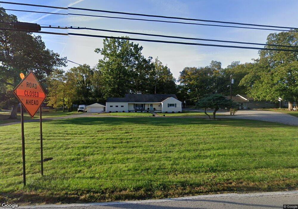
7507 Camby Rd Camby, IN 46113
Camby NeighborhoodEstimated Value: $258,000 - $303,823
2
Beds
2
Baths
1,363
Sq Ft
$206/Sq Ft
Est. Value
About This Home
This home is located at 7507 Camby Rd, Camby, IN 46113 and is currently estimated at $280,206, approximately $205 per square foot. 7507 Camby Rd is a home located in Marion County with nearby schools including West Newton Elementary School, Decatur Middle School, and Decatur Central High School.
Ownership History
Date
Name
Owned For
Owner Type
Purchase Details
Closed on
Dec 5, 2017
Sold by
Church Phillip
Bought by
Church 7507 Camby Road Trust
Current Estimated Value
Purchase Details
Closed on
Feb 3, 2013
Sold by
Ward Mary E
Bought by
Church Phillip
Purchase Details
Closed on
Mar 13, 2009
Sold by
Ward Mary E
Bought by
Ward Mary E and Church Phillip
Home Financials for this Owner
Home Financials are based on the most recent Mortgage that was taken out on this home.
Original Mortgage
$101,500
Interest Rate
5.01%
Mortgage Type
FHA
Create a Home Valuation Report for This Property
The Home Valuation Report is an in-depth analysis detailing your home's value as well as a comparison with similar homes in the area
Home Values in the Area
Average Home Value in this Area
Purchase History
| Date | Buyer | Sale Price | Title Company |
|---|---|---|---|
| Church 7507 Camby Road Trust | -- | -- | |
| Church Phillip | -- | -- | |
| Ward Mary E | -- | None Available |
Source: Public Records
Mortgage History
| Date | Status | Borrower | Loan Amount |
|---|---|---|---|
| Previous Owner | Ward Mary E | $101,500 |
Source: Public Records
Tax History Compared to Growth
Tax History
| Year | Tax Paid | Tax Assessment Tax Assessment Total Assessment is a certain percentage of the fair market value that is determined by local assessors to be the total taxable value of land and additions on the property. | Land | Improvement |
|---|---|---|---|---|
| 2024 | $3,734 | $277,600 | $30,900 | $246,700 |
| 2023 | $3,734 | $248,000 | $30,900 | $217,100 |
| 2022 | $3,695 | $242,500 | $30,900 | $211,600 |
| 2021 | $2,773 | $172,800 | $30,900 | $141,900 |
| 2020 | $2,541 | $174,200 | $30,900 | $143,300 |
| 2019 | $2,536 | $0 | $0 | $0 |
| 2018 | $3,772 | $145,900 | $30,900 | $115,000 |
| 2017 | $2,206 | $135,300 | $30,900 | $104,400 |
| 2016 | $2,119 | $130,900 | $30,900 | $100,000 |
| 2014 | $1,868 | $129,000 | $30,900 | $98,100 |
| 2013 | $1,708 | $129,000 | $30,900 | $98,100 |
Source: Public Records
Map
Nearby Homes
- 6908 Mendenhall Rd
- 7544 Reynolds Rd
- 7604 Cloudy Ct
- 7611 Cloudy Ct
- 7717 Camby Rd
- 7957 Camby Rd
- 7108 Parkstay Ct
- 8107 Wagman St
- 8301 Camby Rd
- 6859 Levant Ln
- 6838 Henley Way
- 6235 Bunting Dr
- 7601 Milhouse Rd
- 6826 Henley Way
- 6815 Henley Way
- Henley Plan at Cardinal Grove
- Bellamy Plan at Cardinal Grove
- Chatham Plan at Cardinal Grove
- Harmony Plan at Cardinal Grove
- Stamford Plan at Cardinal Grove