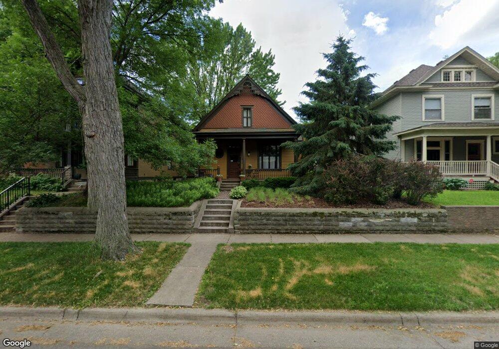
756 Ashland Ave Saint Paul, MN 55104
Summit-University NeighborhoodEstimated Value: $606,000 - $641,000
4
Beds
2
Baths
2,136
Sq Ft
$291/Sq Ft
Est. Value
About This Home
This home is located at 756 Ashland Ave, Saint Paul, MN 55104 and is currently estimated at $621,695, approximately $291 per square foot. 756 Ashland Ave is a home located in Ramsey County with nearby schools including Maxfield Magnet Elementary School, Hidden River Middle School, and Central Senior High School.
Ownership History
Date
Name
Owned For
Owner Type
Purchase Details
Closed on
Aug 26, 2022
Sold by
Borer-Bell Eartha and Borer-Bell Joseph
Bought by
Weber Charles and Weber Polly
Current Estimated Value
Purchase Details
Closed on
Aug 15, 2022
Sold by
Borer-Bell and Joseph
Bought by
Weber Charles William and Weber Polly Lai
Purchase Details
Closed on
Oct 27, 2020
Sold by
Hengelfelt Robert G and Hengelfelt Meike
Bought by
Borer Bell Joseph and Borer Bell Eartha
Home Financials for this Owner
Home Financials are based on the most recent Mortgage that was taken out on this home.
Original Mortgage
$418,400
Interest Rate
2.8%
Mortgage Type
New Conventional
Purchase Details
Closed on
May 16, 2003
Sold by
Galles Daniel C and Galles Amy E
Bought by
Chun Randall T and Chun Peggy J
Create a Home Valuation Report for This Property
The Home Valuation Report is an in-depth analysis detailing your home's value as well as a comparison with similar homes in the area
Home Values in the Area
Average Home Value in this Area
Purchase History
| Date | Buyer | Sale Price | Title Company |
|---|---|---|---|
| Weber Charles | $646,500 | -- | |
| Weber Charles William | $646,500 | None Listed On Document | |
| Borer Bell Joseph | $523,000 | Titlesmart Inc | |
| Chun Randall T | $775,000 | -- |
Source: Public Records
Mortgage History
| Date | Status | Borrower | Loan Amount |
|---|---|---|---|
| Previous Owner | Borer Bell Joseph | $418,400 |
Source: Public Records
Tax History Compared to Growth
Tax History
| Year | Tax Paid | Tax Assessment Tax Assessment Total Assessment is a certain percentage of the fair market value that is determined by local assessors to be the total taxable value of land and additions on the property. | Land | Improvement |
|---|---|---|---|---|
| 2025 | $8,608 | $567,700 | $128,700 | $439,000 |
| 2023 | $8,608 | $549,600 | $128,700 | $420,900 |
| 2022 | $8,042 | $554,800 | $128,700 | $426,100 |
| 2021 | $6,778 | $497,900 | $128,700 | $369,200 |
| 2020 | $6,650 | $424,800 | $128,700 | $296,100 |
| 2019 | $6,250 | $397,000 | $128,700 | $268,300 |
| 2018 | $5,900 | $370,300 | $128,700 | $241,600 |
| 2017 | $5,016 | $360,600 | $141,600 | $219,000 |
| 2016 | $5,668 | $0 | $0 | $0 |
| 2015 | $5,484 | $336,000 | $130,700 | $205,300 |
| 2014 | $5,198 | $0 | $0 | $0 |
Source: Public Records
Map
Nearby Homes
- 742 Holly Ave
- 811 Ashland Ave
- 704 Holly Ave
- 742 Hague Ave
- 676 Ashland Ave Unit 6
- 28 Saint Albans St N Unit 4N
- 818 Summit Ave
- 21 Avon St S Unit 21
- 745 Grand Ave Unit 404
- 51 Avon St S Unit 24
- 63 Avon St S Unit 36
- 681 Dayton Ave
- 652 Dayton Ave
- 695 Lincoln Ave
- 69 Milton St N Unit 3
- 635 Grand Ave Unit 4
- 657 Lincoln Ave
- 565 Holly Ave
- 793 Goodrich Ave
- 579 Summit Ave Unit 105
- 754 Ashland Ave
- 762 Ashland Ave
- 748 Ashland Ave
- 748 748 Ashland Ave
- 770 Ashland Ave
- 763 Holly Ave
- 767 Holly Ave
- 774 Ashland Ave
- 759 Holly Ave
- 741 Holly Ave
- 757 Ashland Ave
- 757 757 Ashland Ave
- 769 Holly Ave
- 753 Ashland Ave
- 763 Ashland Ave
- 763 763 Ashland Ave
- 767 Ashland Ave
- 776 Ashland Ave
- 751 Ashland Ave
- 776 776 Ashland Ave