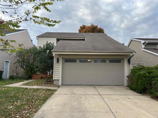
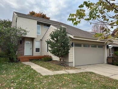
756 Knolls Ct West Des Moines, IA 50265
Estimated payment $1,856/month
Highlights
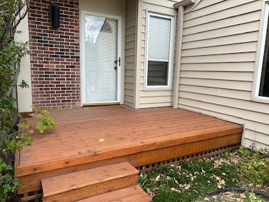
- Popular Property
- Deck
- No HOA
- Crossroads Park Elementary School Rated A-
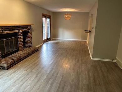
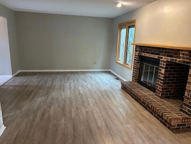
- 1 Fireplace
- Tile Flooring
About This Home
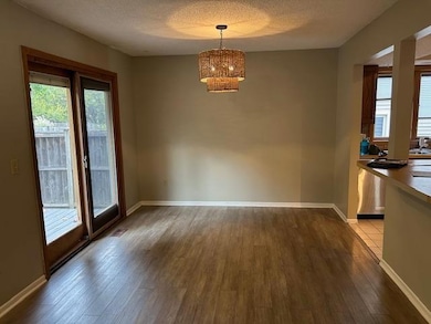
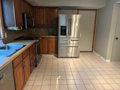
Updated and charming home in the heart of West Des Moines. The living room has a brick fireplace for cozy winter nights. Open stairs with lots of window light to the 2nd floor. The primary bedroom has access to a balcony deck, multiple closets and a primary bathroom. The basement has a finished rec room for extra living space and unfinished storage room and laundry area. All big ticket items taken care of over the years with vinyl siding, windows, gutters, garage door, composite deck in the rear, LVP flooring throughout, bathroom vanities. Close to Jordan Creek Mall, bike paths and schools. Neighborhood park blocks away. All house information has been obtained from public records and/or seller. Offers must be accompanied with pre-approval letter.
Home Details
Home Type
- Single Family
Est. Annual Taxes
- $3,672
Year Built
- Built in 1981
Lot Details
- 5,600 Sq Ft Lot
- Lot Dimensions are 40x140
- Property is Fully Fenced
- Wood Fence
Home Design
- Block Foundation
- Asphalt Shingled Roof
- Vinyl Siding
Interior Spaces
- 1,440 Sq Ft Home
- 2-Story Property
- 1 Fireplace
- Screen For Fireplace
- Family Room
- Dining Area
- Fire and Smoke Detector
- Basement
Kitchen
- Stove
- Microwave
- Dishwasher
Flooring
- Carpet
- Tile
- Luxury Vinyl Plank Tile
Bedrooms and Bathrooms
- 3 Bedrooms
Laundry
- Dryer
- Washer
Parking
- 2 Car Attached Garage
- Driveway
Additional Features
- Deck
- Forced Air Heating and Cooling System
Community Details
- No Home Owners Association
Listing and Financial Details
- Assessor Parcel Number 32004927074000
Map
Home Values in the Area
Average Home Value in this Area
Tax History
| Year | Tax Paid | Tax Assessment Tax Assessment Total Assessment is a certain percentage of the fair market value that is determined by local assessors to be the total taxable value of land and additions on the property. | Land | Improvement |
|---|---|---|---|---|
| 2025 | $3,596 | $244,500 | $43,200 | $201,300 |
| 2024 | $3,596 | $226,900 | $40,000 | $186,900 |
| 2023 | $3,686 | $226,900 | $40,000 | $186,900 |
| 2022 | $3,406 | $190,900 | $34,400 | $156,500 |
| 2021 | $3,348 | $190,900 | $34,400 | $156,500 |
| 2020 | $3,292 | $178,800 | $32,100 | $146,700 |
| 2019 | $3,084 | $178,800 | $32,100 | $146,700 |
| 2018 | $3,086 | $162,300 | $28,600 | $133,700 |
| 2017 | $2,846 | $162,300 | $28,600 | $133,700 |
| 2016 | $2,656 | $146,400 | $25,500 | $120,900 |
| 2015 | $2,656 | $140,500 | $25,500 | $115,000 |
| 2014 | $2,564 | $138,800 | $24,700 | $114,100 |
Property History
| Date | Event | Price | List to Sale | Price per Sq Ft |
|---|---|---|---|---|
| 11/01/2025 11/01/25 | Price Changed | $294,000 | -4.9% | $204 / Sq Ft |
| 10/25/2025 10/25/25 | For Sale | $309,000 | -- | $215 / Sq Ft |
Purchase History
| Date | Type | Sale Price | Title Company |
|---|---|---|---|
| Legal Action Court Order | $170,000 | None Available | |
| Quit Claim Deed | -- | Itc |
Mortgage History
| Date | Status | Loan Amount | Loan Type |
|---|---|---|---|
| Open | $136,000 | New Conventional | |
| Previous Owner | $82,000 | Purchase Money Mortgage |
Source: Des Moines Area Association of REALTORS®
MLS Number: 729148
APN: 320-04927074000
Disclaimer: Certain information contained herein is derived from information provided by parties other than Homes.com. All information provided is deemed reliable, but is not guaranteed to be accurate and should be independently verified.
![]() IDX information is provided exclusively for personal, non-commercial use, and may not be used for any purpose other than to identify prospective properties consumers may be interested in purchasing. Information is deemed reliable but not guaranteed.
IDX information is provided exclusively for personal, non-commercial use, and may not be used for any purpose other than to identify prospective properties consumers may be interested in purchasing. Information is deemed reliable but not guaranteed.
- 724 Knolls Ct
- 5255 Dakota Dr
- 5207 Pommel Place
- 5242 Dakota Dr
- 608 53rd St
- 5101 Dakota Dr
- 513 52nd St
- 521 51st St
- 509 53rd St
- 455 52nd Place
- 5005 Colt Dr
- 813 56th St
- 1032 Bradford Place
- 1041 Bradford Place
- 5480 Dakota Dr
- 1067 Bradford Place
- 636 47th St
- 4808 Stonebridge Rd
- 4817 Westbrooke Place
- 4917 Westbrooke Place
- 5234 Boulder Dr
- 5250 Dakota Dr
- 1101 Prairie View Dr
- 238 52nd St
- 225 Prairie View Dr
- 4957-4949 Woodland Ave
- 5699 Vista Dr
- 4700 Ep True Pkwy
- 4901 Pleasant St
- 1301 49th St
- 4403 Woodland Ave
- 5901 Vista Dr
- 4601 Pleasant St
- 6201 Ep True Pkwy
- 1340 42nd St
- 210 S Prairie View Dr
- 4101 Woodland Plaza
- 6370 Ep True Pkwy
- 4001 Ep True Pkwy
- 3901 Woodland Ave
