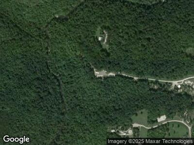
758 End of Trail Ln Allardt, TN 38504
Estimated Value: $519,907 - $672,000
--
Bed
--
Bath
1,920
Sq Ft
$300/Sq Ft
Est. Value
About This Home
This home is located at 758 End of Trail Ln, Allardt, TN 38504 and is currently estimated at $576,302, approximately $300 per square foot. 758 End of Trail Ln is a home.
Ownership History
Date
Name
Owned For
Owner Type
Purchase Details
Closed on
May 26, 2021
Sold by
Allardt Land Company Inc
Bought by
Bacon James O and Achillich Nancy Lee
Current Estimated Value
Purchase Details
Closed on
May 23, 2021
Sold by
Bacon James O and Achillich Nancy Lee
Bought by
Howard Amanda M
Purchase Details
Closed on
May 6, 2021
Sold by
Johnson Bruce H and King Beverly A
Bought by
Allardt Land Company Inc
Purchase Details
Closed on
Jun 21, 2019
Sold by
Johnson Bruce H and King Beverly A
Bought by
Howard Amanda M
Purchase Details
Closed on
Dec 27, 2007
Bought by
Allartd Land Co
Purchase Details
Closed on
Jul 2, 2007
Bought by
Cook Debra and Cook Sue Jeffreys
Create a Home Valuation Report for This Property
The Home Valuation Report is an in-depth analysis detailing your home's value as well as a comparison with similar homes in the area
Home Values in the Area
Average Home Value in this Area
Purchase History
| Date | Buyer | Sale Price | Title Company |
|---|---|---|---|
| Bacon James O | $66,250 | None Available | |
| Howard Amanda M | $59,625 | None Available | |
| Allardt Land Company Inc | -- | None Available | |
| Howard Amanda M | $64,000 | None Available | |
| Johnson Bruce H | $65,000 | None Available | |
| Allartd Land Co | $58,000 | -- | |
| Cook Debra | $58,400 | -- |
Source: Public Records
Mortgage History
| Date | Status | Borrower | Loan Amount |
|---|---|---|---|
| Open | Perry Donna | $40,086 |
Source: Public Records
Tax History Compared to Growth
Tax History
| Year | Tax Paid | Tax Assessment Tax Assessment Total Assessment is a certain percentage of the fair market value that is determined by local assessors to be the total taxable value of land and additions on the property. | Land | Improvement |
|---|---|---|---|---|
| 2024 | $1,631 | $120,800 | $19,950 | $100,850 |
| 2023 | $269 | $120,800 | $19,950 | $100,850 |
| 2022 | $381 | $19,950 | $19,950 | $0 |
| 2021 | $381 | $19,950 | $19,950 | $0 |
| 2020 | $381 | $19,950 | $19,950 | $0 |
| 2019 | $381 | $19,950 | $19,950 | $0 |
| 2018 | $381 | $19,950 | $19,950 | $0 |
| 2017 | $326 | $16,450 | $16,450 | $0 |
| 2016 | $326 | $16,450 | $16,450 | $0 |
| 2015 | $326 | $16,446 | $0 | $0 |
| 2014 | $326 | $16,446 | $0 | $0 |
Source: Public Records
Map
Nearby Homes
- 20 Bluff View Loop
- 145 Horse Haven Rd
- 0 Coyote Trail
- 1032 Range Cemetery Rd
- 1070 Chestnut Ridge Rd
- 50 acres Oloff Smith Rd
- lot 17 Long Ridge Way
- 0 Sam Smith Rd Unit RTC2865905
- 0 Sam Smith Rd Unit 236295
- 3540 Stockton Rd
- 0 72 Acres Cole Place Rd
- 21.31 Cole Place Rd
- 499 Stockton Chapel Rd
- 15.31 AC Rugby Pike
- 182 Stockton Chapel Rd
- Lot 24 Old Mount Helen Rd
- Lot 23 Old Mount Helen Rd
- Lot 19 Old Mount Helen Rd
- Lot 13 Old Mount Helen Rd
- 0 Old Mount Helen Rd
