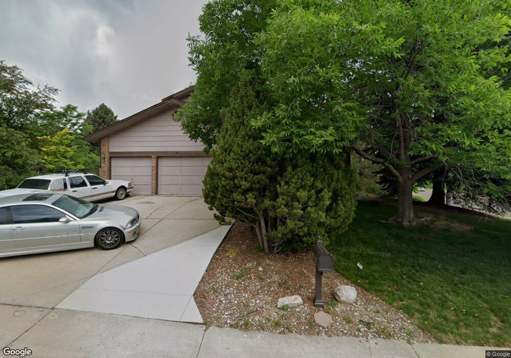
7609 S Hahns Peak Littleton, CO 80127
Estimated Value: $905,524 - $1,126,000
5
Beds
5
Baths
3,074
Sq Ft
$335/Sq Ft
Est. Value
About This Home
This home is located at 7609 S Hahns Peak, Littleton, CO 80127 and is currently estimated at $1,030,631, approximately $335 per square foot. 7609 S Hahns Peak is a home located in Jefferson County with nearby schools including Shaffer Elementary School, Falcon Bluffs Middle School, and Chatfield High School.
Ownership History
Date
Name
Owned For
Owner Type
Purchase Details
Closed on
Aug 19, 2025
Sold by
Googins John B
Bought by
Googins Family Trust
Current Estimated Value
Purchase Details
Closed on
Mar 15, 2024
Sold by
Googins Paula A
Bought by
Googins John B and Googins Paula A
Purchase Details
Closed on
Nov 19, 1999
Sold by
Meine James E Meine Connie J
Bought by
Googins Paula A
Create a Home Valuation Report for This Property
The Home Valuation Report is an in-depth analysis detailing your home's value as well as a comparison with similar homes in the area
Home Values in the Area
Average Home Value in this Area
Purchase History
| Date | Buyer | Sale Price | Title Company |
|---|---|---|---|
| Googins Family Trust | -- | None Listed On Document | |
| Googins John B | -- | None Listed On Document | |
| Googins Paula A | $337,000 | -- |
Source: Public Records
Tax History Compared to Growth
Tax History
| Year | Tax Paid | Tax Assessment Tax Assessment Total Assessment is a certain percentage of the fair market value that is determined by local assessors to be the total taxable value of land and additions on the property. | Land | Improvement |
|---|---|---|---|---|
| 2024 | $5,156 | $54,855 | $19,763 | $35,092 |
| 2023 | $5,156 | $54,855 | $19,763 | $35,092 |
| 2022 | $4,071 | $44,143 | $16,472 | $27,671 |
| 2021 | $4,134 | $45,414 | $16,946 | $28,468 |
| 2020 | $3,749 | $41,965 | $14,801 | $27,164 |
| 2019 | $3,705 | $41,965 | $14,801 | $27,164 |
| 2018 | $3,747 | $41,211 | $12,612 | $28,599 |
| 2017 | $3,485 | $41,211 | $12,612 | $28,599 |
| 2016 | $3,644 | $41,612 | $12,176 | $29,436 |
| 2015 | $3,721 | $41,612 | $12,176 | $29,436 |
| 2014 | $3,721 | $40,341 | $10,642 | $29,699 |
Source: Public Records
Map
Nearby Homes
- 7646 S Bear Mountain
- 11235 San Joaquin Ridge
- 7462 S Quail Cir Unit 426
- 7433 S Quail Cir Unit 1924
- 11673 Elk Head Range Rd
- 7413 S Quail Cir Unit 1422
- 7413 S Quail Cir Unit 1435
- 11703 Elk Head Range Rd
- 8140 S Storm King Peak
- 11710 Elk Head Range Rd
- 7825 Sand Mountain
- 11872 Elk Head Range Rd
- 8196 S Spring Creek Pass
- 7369 S Gore Range Rd Unit 208
- 10645 W Sundance Mountain
- 7339 S Gore Range Rd
- 7474 S Alkire St Unit 203
- 10866 W Half Moon Pass
- 11434 W Roxbury Dr
- 10371 W Indore Dr
- 7619 S Hahns Peak
- 7639 S Hahns Peak
- 7629 S Hahns Peak
- 7608 S Hahns Peak
- 7587 Parkview Mountain
- 11219 W Park Range Rd
- 7638 S Hahns Peak
- 7622 S Davis Peak
- 7597 Parkview Mountain
- 7652 S Davis Peak
- 7618 S Hahns Peak
- 7612 S Davis Peak
- 7577 Parkview Mountain
- 7659 S Hahns Peak
- 7628 S Hahns Peak
- 7649 S Hahns Peak
- 7642 S Davis Peak
- 7662 S Davis Peak
- 7648 S Hahns Peak
- 7658 S Hahns Peak