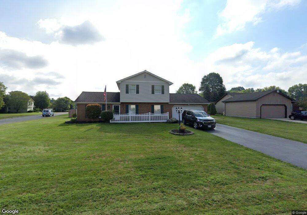
7613 Buchanan Dr Youngstown, OH 44512
Estimated Value: $286,155 - $319,000
3
Beds
2
Baths
2,121
Sq Ft
$144/Sq Ft
Est. Value
About This Home
This home is located at 7613 Buchanan Dr, Youngstown, OH 44512 and is currently estimated at $305,039, approximately $143 per square foot. 7613 Buchanan Dr is a home located in Mahoning County with nearby schools including Robinwood Lane Elementary School, Boardman Glenwood Junior High School, and Boardman High School.
Ownership History
Date
Name
Owned For
Owner Type
Purchase Details
Closed on
Jul 30, 1999
Sold by
Ford Ralph C and Ford Diane
Bought by
Guidos John A and Guidos Pamela J
Current Estimated Value
Purchase Details
Closed on
Dec 6, 1982
Bought by
Ford Ralph C and Ford Diane
Create a Home Valuation Report for This Property
The Home Valuation Report is an in-depth analysis detailing your home's value as well as a comparison with similar homes in the area
Home Values in the Area
Average Home Value in this Area
Purchase History
We collect this data history from publicly available records. To have your information removed, we recommend requesting removal directly through your county’s website.
| Date | Buyer | Sale Price | Title Company |
|---|---|---|---|
| Guidos John A | $107,000 | -- | |
| Ford Ralph C | -- | -- |
Source: Public Records
Mortgage History
We collect this data history from publicly available records. To have your information removed, we recommend requesting removal directly through your county’s website.
| Date | Status | Borrower | Loan Amount |
|---|---|---|---|
| Closed | Guidos John A | $0 |
Source: Public Records
Tax History
| Year | Tax Paid | Tax Assessment Tax Assessment Total Assessment is a certain percentage of the fair market value that is determined by local assessors to be the total taxable value of land and additions on the property. | Land | Improvement |
|---|---|---|---|---|
| 2025 | $4,141 | $83,000 | $16,650 | $66,350 |
| 2024 | $4,237 | $83,000 | $16,650 | $66,350 |
| 2023 | $4,180 | $83,000 | $16,650 | $66,350 |
| 2022 | $4,112 | $62,460 | $12,820 | $49,640 |
| 2021 | $4,114 | $62,460 | $12,820 | $49,640 |
| 2020 | $4,135 | $62,460 | $12,820 | $49,640 |
| 2019 | $3,738 | $49,840 | $11,650 | $38,190 |
| 2018 | $3,254 | $49,840 | $11,650 | $38,190 |
| 2017 | $3,256 | $49,840 | $11,650 | $38,190 |
| 2016 | $3,309 | $51,020 | $12,910 | $38,110 |
| 2015 | $3,244 | $51,020 | $12,910 | $38,110 |
| 2014 | $3,253 | $51,020 | $12,910 | $38,110 |
| 2013 | $3,212 | $51,020 | $12,910 | $38,110 |
Source: Public Records
Map
Nearby Homes
- 912 Pearson Cir Unit 5
- 675 Presidential Dr
- 918 Pearson Cir Unit 2
- 852 Pearson Cir Unit 3
- 0 Saddlebrook Lot 156 Dr Unit 5201639
- 0 Saddlebrook Lot 123 Dr Unit 5201636
- 0 Saddlebrook Lot 153 Dr Unit 5201645
- 7357 Eisenhower Dr Unit 6
- 7374 Eisenhower Dr Unit 3
- 681 Saddlebrook Dr
- 607 Chestnut Ln
- 7863 Walnut St Unit A
- 1530 Rosehedge Dr
- 0 Wood Ave Unit 5199522
- 0 Wood Ave Unit 5199483
- 0 Wood Ave Unit 5199520
- 0 Wood Ave Unit 5199514
- 0 Wood Ave Unit 5202352
- 0 Wood Ave Unit 5202351
- 222 Boardman Blvd
- 7621 Buchanan Dr
- 7605 Buchanan Dr
- 7629 Buchanan Dr
- 7557 Buchanan Dr
- 803 Presidential Dr
- 7553 Buchanan Dr
- 7597 Buchanan Dr
- 7549 Buchanan Dr
- 7561 Buchanan Dr
- 7637 Buchanan Dr
- 797 Presidential Dr
- 7632 Franco Ct
- 7604 Buchanan Dr
- 7545 Buchanan Dr
- 7571 Buchanan Dr
- 7645 Buchanan Dr
- 7636 Franco Ct
- 7589 Buchanan Dr
- 7600 Buchanan Dr
- 791 Presidential Dr
Your Personal Tour Guide
Ask me questions while you tour the home.