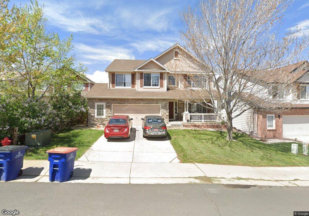
7653 Rampart Way Littleton, CO 80125
Estimated Value: $763,119 - $845,000
4
Beds
3
Baths
2,743
Sq Ft
$293/Sq Ft
Est. Value
About This Home
This home is located at 7653 Rampart Way, Littleton, CO 80125 and is currently estimated at $805,030, approximately $293 per square foot. 7653 Rampart Way is a home located in Douglas County with nearby schools including Roxborough Elementary School, Roxborough Intermediate School, and Ranch View Middle School.
Ownership History
Date
Name
Owned For
Owner Type
Purchase Details
Closed on
Dec 22, 2015
Sold by
Olds Clay D
Bought by
Craven Denise A
Current Estimated Value
Purchase Details
Closed on
Mar 6, 2000
Sold by
Engle Homes Colorado Inc
Bought by
Olds Clay D and Craven Denise A
Home Financials for this Owner
Home Financials are based on the most recent Mortgage that was taken out on this home.
Original Mortgage
$192,900
Interest Rate
8.36%
Purchase Details
Closed on
Mar 31, 1999
Sold by
Rv Southwest Investments Llc
Bought by
Engle Homes Colorado
Create a Home Valuation Report for This Property
The Home Valuation Report is an in-depth analysis detailing your home's value as well as a comparison with similar homes in the area
Home Values in the Area
Average Home Value in this Area
Purchase History
| Date | Buyer | Sale Price | Title Company |
|---|---|---|---|
| Craven Denise A | -- | None Available | |
| Olds Clay D | $264,700 | Universal Land Title | |
| Engle Homes Colorado | $600,000 | -- |
Source: Public Records
Mortgage History
| Date | Status | Borrower | Loan Amount |
|---|---|---|---|
| Previous Owner | Olds Clay D | $192,900 |
Source: Public Records
Tax History Compared to Growth
Tax History
| Year | Tax Paid | Tax Assessment Tax Assessment Total Assessment is a certain percentage of the fair market value that is determined by local assessors to be the total taxable value of land and additions on the property. | Land | Improvement |
|---|---|---|---|---|
| 2024 | $5,262 | $54,030 | $8,480 | $45,550 |
| 2023 | $5,297 | $54,030 | $8,480 | $45,550 |
| 2022 | $3,860 | $36,900 | $6,170 | $30,730 |
| 2021 | $4,034 | $36,900 | $6,170 | $30,730 |
| 2020 | $4,081 | $35,210 | $7,070 | $28,140 |
| 2019 | $4,147 | $35,210 | $7,070 | $28,140 |
| 2018 | $4,480 | $31,070 | $5,420 | $25,650 |
| 2017 | $4,305 | $31,070 | $5,420 | $25,650 |
| 2016 | $4,102 | $29,240 | $6,410 | $22,830 |
| 2015 | $4,238 | $29,240 | $6,410 | $22,830 |
| 2014 | $3,857 | $24,750 | $5,950 | $18,800 |
Source: Public Records
Map
Nearby Homes
- 7832 Elmwood St
- 7597 Bison Ct
- 7680 Elmwood St
- 7627 Halleys Dr
- 7653 Kyle Way
- 7888 Canvasback Cir
- 8032 Mount Ouray Rd
- 7719 Jared Way
- 7575 Elmwood St
- 8109 Mount Ouray Rd
- 7910 Jared Way
- 7217 Red Mesa Ct
- 9650 Fox Den Dr
- 8145 Monte Vista Cir
- 7191 Red Mesa Dr
- 8129 Locust Dr
- 7712 Brown Bear Way
- 9753 Middle Peak St
- 9508 Elk Mountain Cir
- 8132 Mount Harvard Rd
- 7643 Rampart Way
- 7665 Rampart Way
- 7677 Rampart Way
- 7639 Rampart Way
- 7687 Rampart Way
- 7656 Rampart Way
- 7695 Rampart Way
- 7646 Rampart Way
- 7635 Rampart Way
- 7668 Rampart Way
- 7640 Rampart Way
- 7633 Rampart Way
- 7674 Rampart Way
- 7703 Rampart Way
- 7634 Rampart Way
- 7678 Rampart Way
- 7684 Rampart Way
- 7698 Rampart Way
- 7690 Rampart Way
- 7665 Verandah Ct