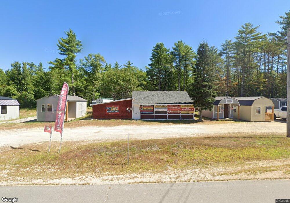
766 Route 16 Ossipee, NH 03864
Estimated Value: $223,000 - $326,000
1
Bed
1
Bath
1,055
Sq Ft
$258/Sq Ft
Est. Value
About This Home
This home is located at 766 Route 16, Ossipee, NH 03864 and is currently estimated at $272,159, approximately $257 per square foot. 766 Route 16 is a home with nearby schools including Ossipee Central School, Kingswood Regional Middle School, and Kingswood Regional High School.
Ownership History
Date
Name
Owned For
Owner Type
Purchase Details
Closed on
Feb 9, 2022
Sold by
J L & Barbara J Hehl Ret
Bought by
Rachel Sheds Llc
Current Estimated Value
Home Financials for this Owner
Home Financials are based on the most recent Mortgage that was taken out on this home.
Original Mortgage
$118,434
Outstanding Balance
$109,988
Interest Rate
3.56%
Mortgage Type
Commercial
Estimated Equity
$162,171
Purchase Details
Closed on
Mar 6, 2013
Sold by
Hehl Jacob L and Hehl Barbara J
Bought by
Jacob L&B Hehl Ret and Hehl Jacob L
Create a Home Valuation Report for This Property
The Home Valuation Report is an in-depth analysis detailing your home's value as well as a comparison with similar homes in the area
Home Values in the Area
Average Home Value in this Area
Purchase History
| Date | Buyer | Sale Price | Title Company |
|---|---|---|---|
| Rachel Sheds Llc | $155,400 | None Available | |
| Jacob L&B Hehl Ret | -- | -- |
Source: Public Records
Mortgage History
| Date | Status | Borrower | Loan Amount |
|---|---|---|---|
| Open | Rachel Sheds Llc | $118,434 |
Source: Public Records
Tax History Compared to Growth
Tax History
| Year | Tax Paid | Tax Assessment Tax Assessment Total Assessment is a certain percentage of the fair market value that is determined by local assessors to be the total taxable value of land and additions on the property. | Land | Improvement |
|---|---|---|---|---|
| 2024 | $2,845 | $245,300 | $201,500 | $43,800 |
| 2023 | $2,544 | $245,300 | $201,500 | $43,800 |
| 2022 | $2,215 | $120,500 | $89,000 | $31,500 |
| 2021 | $2,288 | $124,800 | $89,000 | $35,800 |
| 2020 | $2,128 | $124,800 | $89,000 | $35,800 |
| 2019 | $2,135 | $124,800 | $89,000 | $35,800 |
| 2018 | $1,730 | $95,600 | $64,500 | $31,100 |
| 2016 | $1,951 | $101,100 | $64,500 | $36,600 |
| 2015 | $1,853 | $101,100 | $64,500 | $36,600 |
| 2014 | $1,831 | $101,600 | $39,500 | $62,100 |
| 2013 | $1,767 | $101,600 | $39,500 | $62,100 |
Source: Public Records
Map
Nearby Homes
- 00B Route 16
- 954 Route 16
- 20 Hawthorne Rd
- 22 Hawthorne Rd
- 6 Wellington Ct
- 7 Hawthorne Rd
- 13 Wellington Ct
- 11 Wellington Ct
- 5 Wellington Ct
- 1 Hawthorne Rd
- 85 Old Granite Rd
- 4 Brookwood Dr
- 16 Isaac Buswell Rd
- 6 Abbott Ln
- 45 Old Granite Rd
- 16 Pollys Crossing Rd
- 1060 Route 16
- 110 Elm St
- 45 Effingham Rd
- 5 John Terrace
- 5 Margarets Way
- 27 Margaret's Way
- 14 Margaret's Way
- 21 Margarets Way
- 760 White Mountain Hwy Unit C1-A
- 760 White Mountain Hwy Unit C1-B
- 801 Route 16
- 6 Margarets Way
- 4 Margarets Way
- 766 White Mountain Hwy
- 7 Margarets Way
- 3 Margarets Way
- 2 Margarets Way
- 1 Margarets Way
- Lot 11 Elm Street Extension
- 0 Margarets Way Unit 2 4829708
- 9 Margarets Way
- 18 Margaret's Way
- 7 Margaret's Way
- 35 Margaret's Way