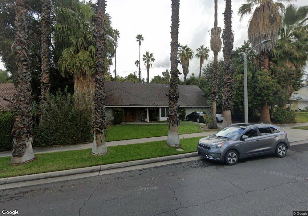
767 Apache Trail Riverside, CA 92507
Canyon Crest NeighborhoodEstimated Value: $730,000 - $798,000
4
Beds
2
Baths
2,727
Sq Ft
$278/Sq Ft
Est. Value
About This Home
This home is located at 767 Apache Trail, Riverside, CA 92507 and is currently estimated at $758,047, approximately $277 per square foot. 767 Apache Trail is a home located in Riverside County with nearby schools including Emerson Elementary School, University Heights Middle School, and John W. North High School.
Ownership History
Date
Name
Owned For
Owner Type
Purchase Details
Closed on
Oct 17, 2012
Sold by
Cole Christopher and Cole Bonnelyn
Bought by
Cole Christopher and Cole Christine L
Current Estimated Value
Home Financials for this Owner
Home Financials are based on the most recent Mortgage that was taken out on this home.
Original Mortgage
$204,700
Outstanding Balance
$35,233
Interest Rate
3.5%
Mortgage Type
New Conventional
Estimated Equity
$722,814
Purchase Details
Closed on
Jun 23, 2003
Sold by
Cole Michael D
Bought by
Cole Bonnelyn
Home Financials for this Owner
Home Financials are based on the most recent Mortgage that was taken out on this home.
Original Mortgage
$240,000
Interest Rate
5.29%
Mortgage Type
Purchase Money Mortgage
Purchase Details
Closed on
Mar 3, 1998
Sold by
Thomas Eugene R and Thomas Joan A
Bought by
Thomas Eugene R and Thomas Joan Anne
Create a Home Valuation Report for This Property
The Home Valuation Report is an in-depth analysis detailing your home's value as well as a comparison with similar homes in the area
Home Values in the Area
Average Home Value in this Area
Purchase History
| Date | Buyer | Sale Price | Title Company |
|---|---|---|---|
| Cole Christopher | -- | Lsi Title | |
| Cole Bonnelyn | -- | Chicago Title Co | |
| Cole Christopher | $300,000 | Chicago Title Co | |
| Thomas Eugene R | -- | -- |
Source: Public Records
Mortgage History
| Date | Status | Borrower | Loan Amount |
|---|---|---|---|
| Open | Cole Christopher | $204,700 | |
| Previous Owner | Cole Christopher | $240,000 | |
| Closed | Cole Christopher | $30,000 |
Source: Public Records
Tax History
| Year | Tax Paid | Tax Assessment Tax Assessment Total Assessment is a certain percentage of the fair market value that is determined by local assessors to be the total taxable value of land and additions on the property. | Land | Improvement |
|---|---|---|---|---|
| 2025 | $4,618 | $424,264 | $107,070 | $317,194 |
| 2023 | $4,618 | $407,791 | $102,913 | $304,878 |
| 2022 | $4,514 | $399,796 | $100,896 | $298,900 |
| 2021 | $4,456 | $391,958 | $98,918 | $293,040 |
| 2020 | $4,280 | $375,151 | $97,904 | $277,247 |
| 2019 | $4,199 | $367,796 | $95,985 | $271,811 |
| 2018 | $4,118 | $360,585 | $94,104 | $266,481 |
| 2017 | $4,045 | $353,515 | $92,259 | $261,256 |
| 2016 | $3,786 | $346,584 | $90,450 | $256,134 |
| 2015 | $3,732 | $341,381 | $89,093 | $252,288 |
| 2014 | $3,697 | $334,696 | $87,349 | $247,347 |
Source: Public Records
Map
Nearby Homes
- 5110 Caldera Ct
- 5015 Pearblossom Dr
- 511 Athens St
- 7 Gage
- 375 Central Ave Unit 124
- 375 Central Ave Unit 78
- 375 Central Ave Unit 14
- 375 Central Ave Unit 24
- 375 Central Ave Unit 83
- 1000 Central Ave Unit 8
- 600 Central Ave Unit 291
- 600 Central Ave Unit 332
- 718 Via la Paloma
- 4360 Watkins Dr
- 1250 Blazewood St
- 4495 Mt Vernon Ave
- 680 Via Zapata
- 5555 Canyon Crest Dr Unit 2G
- 134 W Broadbent Dr
- 20995 Mountain Gate Dr
- 779 Apache Trail
- 772 S University Dr
- 735 Apache Trail
- 789 Apache Trail
- 750 Apache Trail
- 768 Apache Trail
- 780 Apache Trail
- 768 S University Dr
- 719 Apache Trail
- 801 Apache Trail
- 798 Apache Trail
- 751 Navajo Dr
- 737 Navajo Dr
- 767 Navajo Dr
- 808 University Place
- 705 Apache Trail
- 815 Apache Trail
- 810 Apache Trail
- 702 Navajo Dr
- 789 Navajo Dr
Your Personal Tour Guide
Ask me questions while you tour the home.