767 Driver Ln Dillard, GA 30537
Estimated payment $2,483/month
Highlights
- Golf Course Community
- Clubhouse
- Furnished
- Fitness Center
- Vaulted Ceiling
- No HOA
About This Home
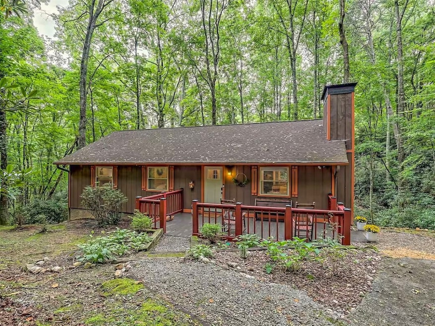
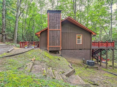
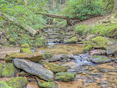
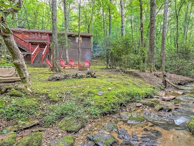
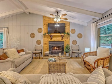
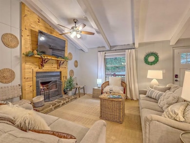
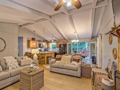
Escape to serenity at this beautifully renovated home tucked away in the tranquil woods of the Northeast Georgia Mountains at Sky Valley Resort. This 3-bedroom, 2-bathroom home boasts a private, shaded backyard bordered by a babbling creek. Unwind by the inviting firepit under a canopy of trees. Inside, the great room captivates with soaring vaulted ceilings, exposed beams, and a cozy fireplace, seamlessly flowing into a modern kitchen and dining area. The updated kitchen features plenty of storage and stainless still appliances with a breakfast bar, perfect for hosting guests and family. This one level retreat is great for full-time living or a peaceful mountain getaway. Enjoy optional membership to Sky Valley Resort’s amenities just minutes away, all set against the breathtaking backdrop of the mountains. Don’t miss this opportunity to relax to the sounds of flowing water in the North Georgia mountains!
Home Details
Home Type
- Single Family
Est. Annual Taxes
- $2,563
Year Built
- Built in 1980
Lot Details
- 23,522 Sq Ft Lot
- Home fronts a stream
- Sloped Lot
Home Design
- Shingle Roof
Interior Spaces
- 1-Story Property
- Furnished
- Vaulted Ceiling
- Living Room with Fireplace
- Property Views
Kitchen
- Breakfast Bar
- Microwave
- Dishwasher
Flooring
- Tile
- Vinyl
Bedrooms and Bathrooms
- 3 Bedrooms
- 2 Full Bathrooms
Outdoor Features
- Fire Pit
Utilities
- Central Heating and Cooling System
- Septic Tank
- Phone Available
- Cable TV Available
Listing and Financial Details
- Tax Lot 58
- Assessor Parcel Number 058B 035
Community Details
Overview
- No Home Owners Association
- Sky Valley Subdivision
Amenities
- Clubhouse
Recreation
- Golf Course Community
- Tennis Courts
- Pickleball Courts
- Community Playground
- Fitness Center
- Community Pool
- Putting Green
Map
Home Values in the Area
Average Home Value in this Area
Tax History
| Year | Tax Paid | Tax Assessment Tax Assessment Total Assessment is a certain percentage of the fair market value that is determined by local assessors to be the total taxable value of land and additions on the property. | Land | Improvement |
|---|---|---|---|---|
| 2025 | $2,887 | $104,509 | $20,000 | $84,509 |
| 2024 | $2,759 | $99,893 | $20,000 | $79,893 |
| 2023 | $2,446 | $78,164 | $16,000 | $62,164 |
| 2022 | $1,305 | $71,314 | $14,000 | $57,314 |
| 2021 | $1,111 | $59,241 | $8,000 | $51,241 |
| 2020 | $920 | $49,437 | $8,000 | $41,437 |
| 2019 | $907 | $46,423 | $8,000 | $38,423 |
| 2018 | $843 | $42,979 | $8,000 | $34,979 |
| 2017 | $808 | $42,979 | $8,000 | $34,979 |
| 2016 | $810 | $42,979 | $8,000 | $34,979 |
| 2015 | $816 | $42,366 | $8,000 | $34,366 |
| 2014 | $724 | $37,386 | $7,200 | $30,186 |
Property History
| Date | Event | Price | List to Sale | Price per Sq Ft |
|---|---|---|---|---|
| 11/03/2025 11/03/25 | For Sale | $424,900 | -- | -- |
Purchase History
| Date | Type | Sale Price | Title Company |
|---|---|---|---|
| Warranty Deed | $365,000 | -- | |
| Warranty Deed | $192,000 | -- | |
| Warranty Deed | $192,000 | -- | |
| Warranty Deed | $138,000 | -- | |
| Warranty Deed | $138,000 | -- | |
| Deed | -- | -- | |
| Deed | -- | -- | |
| Warranty Deed | $66,500 | -- | |
| Warranty Deed | $66,500 | -- | |
| Warranty Deed | $8,000 | -- | |
| Warranty Deed | $8,000 | -- | |
| Warranty Deed | $8,500 | -- | |
| Warranty Deed | $8,500 | -- |
Source: Highlands-Cashiers Board of REALTORS®
MLS Number: 1001998
APN: 058B-035
- 340 Eagle Cir
- 63 Mashie Ln
- 70 Fairway Ln
- 594 Sky High Dr
- 480 Sky High Dr
- 226 Moon Ridge Dr
- 0 LOT 41 Pipetrack Gap Rd
- 156 Tahoe Ln
- LOT 35 Thomas Knob Estates Rd
- 42 Lost Valley Dr
- 119 Buttermilk Cir
- 115 Dam Lake Dr
- 0 Saddleback Cir Unit 10538862
- 452 E Sugarbush Dr
- 3 Berkshire Ln Unit 3
- 0 Bald Mountain Rd Unit LOT 8 10361713
- 0 Bald Mountain Rd Unit 55,57
- 41 Peek and Peak Dr
- 0 Ridgepole Dr SE Unit 10557269
- 0 Ridgepole Dr SE Unit 26020295
- 21 Staghorn Point
- 160 Marsen Knob Dr
- 105 W Z
- 18 Living Waters Way
- 56 Oak Crescent Cir
- 171 Cullasaja Cir
- 250 Lovell Ln
- 322 Gobbler Knob Rd
- 138 Sloan St
- 103 Bent Grass Way
- 37 Wayah Dr
- 810- C O 810- C Oak Creek Rd
- 78 Antebellum Ln
- 651 Chalk Hill Rd
- 120 Jaderian Mountain Rd
- 960 Robbins Rd
- 33 Jaderian Mountain Rd
- 21 Idylwood Dr
- 36 Peak Dr
- 55 Alta View Dr

Ask me questions while you tour the home.