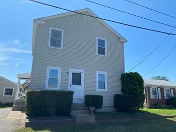
77 Manistee St Pawtucket, RI 02861
Darlington NeighborhoodEstimated payment $2,390/month
Highlights
- Colonial Architecture
- Window Unit Cooling System
- Baseboard Heating
- 1 Car Detached Garage
About This Home
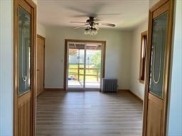
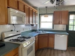
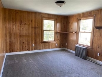
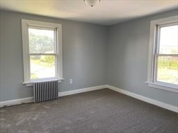
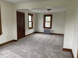
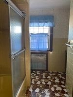
This well maintained home has 3 bedrooms, 1 bath, spacious living room, dining room, kitchen, new wall to wall carpeting and laminate wood floors, plenty of closet space, detached garage and plenty of off street parking for up to 5 cars. Sliding patio door to covered porch, very large private fenced in yard. Range, Dishwasher, Refrigerator, washer and dryer to stay in as is condition. Conveniently located just a short distance to the train station, shopping, Slater Park, Pawtucket Boat Launch, Festival Pier, and Ledgemont Country Club. Easy access to major highways and amenities. Perfect for your first time home buyer.
Listing Agent
Ponte & Associates Real Estate License #REB.0016282 Listed on: 10/06/2025
Home Details
Home Type
- Single Family
Est. Annual Taxes
- $4,024
Year Built
- Built in 1902
Lot Details
- 8,000 Sq Ft Lot
Parking
- 1 Car Detached Garage
Home Design
- Colonial Architecture
- Block Foundation
- Vinyl Siding
Interior Spaces
- 1,248 Sq Ft Home
- 2-Story Property
- Laminate Flooring
Bedrooms and Bathrooms
- 3 Bedrooms
- 1 Full Bathroom
Unfinished Basement
- Basement Fills Entire Space Under The House
- Interior Basement Entry
Utilities
- Window Unit Cooling System
- Heating System Uses Gas
- Baseboard Heating
- 100 Amp Service
- Gas Water Heater
Listing and Financial Details
- Tax Lot 967
- Assessor Parcel Number 77MANISTEESTPAWT
Map
Home Values in the Area
Average Home Value in this Area
Tax History
| Year | Tax Paid | Tax Assessment Tax Assessment Total Assessment is a certain percentage of the fair market value that is determined by local assessors to be the total taxable value of land and additions on the property. | Land | Improvement |
|---|---|---|---|---|
| 2025 | $4,271 | $324,800 | $153,600 | $171,200 |
| 2024 | $4,024 | $326,100 | $153,600 | $172,500 |
| 2023 | $3,937 | $232,400 | $90,300 | $142,100 |
| 2022 | $3,853 | $232,400 | $90,300 | $142,100 |
| 2021 | $3,853 | $232,400 | $90,300 | $142,100 |
| 2020 | $3,645 | $174,500 | $74,700 | $99,800 |
| 2019 | $3,645 | $174,500 | $74,700 | $99,800 |
| 2018 | $3,513 | $174,500 | $74,700 | $99,800 |
| 2017 | $3,281 | $144,400 | $59,800 | $84,600 |
| 2016 | $3,161 | $144,400 | $59,800 | $84,600 |
| 2015 | $3,161 | $144,400 | $59,800 | $84,600 |
| 2014 | $2,972 | $128,900 | $56,700 | $72,200 |
Property History
| Date | Event | Price | List to Sale | Price per Sq Ft |
|---|---|---|---|---|
| 10/06/2025 10/06/25 | For Sale | $389,900 | -- | $312 / Sq Ft |
Purchase History
| Date | Type | Sale Price | Title Company |
|---|---|---|---|
| Warranty Deed | $98,000 | -- |
Mortgage History
| Date | Status | Loan Amount | Loan Type |
|---|---|---|---|
| Open | $100,000 | No Value Available | |
| Closed | $97,000 | No Value Available | |
| Closed | $93,000 | No Value Available |
Source: State-Wide MLS
MLS Number: 1397035
APN: PAWT-000040-000000-000967
Disclaimer: Certain information contained herein is derived from information provided by parties other than Homes.com. All information provided is deemed reliable, but is not guaranteed to be accurate and should be independently verified.
![]() IDX information is provided exclusively for personal, non-commercial use, and may not be used for any purpose other than to identify prospective properties consumers may be interested in purchasing. Information is deemed reliable but not guaranteed.
IDX information is provided exclusively for personal, non-commercial use, and may not be used for any purpose other than to identify prospective properties consumers may be interested in purchasing. Information is deemed reliable but not guaranteed.
Copyright © 2025 State-Wide MLS, Inc. All rights reserved.
- 77 Manistee St
- 496 Beverage Hill Ave
- 10 Maplewood Dr
- 0 Rosella Ave
- 58 Rosella Ave
- 70 Glen Meadows Dr
- 38 Lowell Ave
- 339 Beverage Hill Ave
- 46 Lowell Ave
- 728 Beverage Hill Ave Unit 24
- 98 Dodge St
- 8 Pine Grove St
- 400 Newport Ave
- 122 New Rd
- 32 E Point Dr Unit 2
- 34 E Point Dr Unit 3
- 63 East Dr
- 242 St
- 60 West Dr
- 242 Manton St
- 85 Manistee St Unit 1
- 180 Parkview Dr
- 95 Newport Ave
- 158 Slater Park Ave Unit 1
- 26 Island Ave Unit 28
- 19 Chestnut St Unit 19 chestnut st
- 23 Young St
- 435 Walcott St Unit 3rd floor
- 263 Bourne Ave Unit 1B
- 55 Grove St Unit Third - Penthouse
- 16 Saratoga Ave
- 35 Grove St Unit 2
- 413 Central Ave
- 20 Newman Ave
- 413 Central Ave Unit 3-005
- 20 Newman Ave Unit 11-11302
- 20 Newman Ave Unit 1-1112
- 20 Newman Ave Unit 11-11303
- 20 Newman Ave Unit 1-1102
- 178 Oak Hill Ave Unit First Floor
