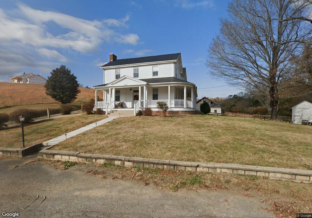
7700 Old Asheville Hwy Greeneville, TN 37743
Estimated Value: $642,000 - $1,686,504
--
Bed
1
Bath
2,717
Sq Ft
$429/Sq Ft
Est. Value
About This Home
This home is located at 7700 Old Asheville Hwy, Greeneville, TN 37743 and is currently estimated at $1,164,252, approximately $428 per square foot. 7700 Old Asheville Hwy is a home located in Greene County with nearby schools including Camp Creek Elementary School, South Greene Middle School, and South Greene High School.
Ownership History
Date
Name
Owned For
Owner Type
Purchase Details
Closed on
Jan 26, 2007
Sold by
Carter Lucille S
Bought by
Miller Rachel Carter
Current Estimated Value
Purchase Details
Closed on
Jun 3, 2005
Sold by
Carter Lucille S
Bought by
Staffier Natalie Carter
Purchase Details
Closed on
Feb 1, 2005
Sold by
Carter Lucille S
Bought by
Miller Rachel Carter
Purchase Details
Closed on
Jan 14, 2004
Sold by
Speares Martha R
Bought by
Staffier Natalie C
Purchase Details
Closed on
May 9, 2003
Sold by
Speares Martha R
Bought by
Miller Rachel C
Create a Home Valuation Report for This Property
The Home Valuation Report is an in-depth analysis detailing your home's value as well as a comparison with similar homes in the area
Home Values in the Area
Average Home Value in this Area
Purchase History
| Date | Buyer | Sale Price | Title Company |
|---|---|---|---|
| Miller Rachel Carter | $12,000 | -- | |
| Staffier Natalie Carter | $10,000 | -- | |
| Miller Rachel Carter | $10,000 | -- | |
| Staffier Natalie C | $10,000 | -- | |
| Miller Rachel C | $10,000 | -- |
Source: Public Records
Tax History Compared to Growth
Tax History
| Year | Tax Paid | Tax Assessment Tax Assessment Total Assessment is a certain percentage of the fair market value that is determined by local assessors to be the total taxable value of land and additions on the property. | Land | Improvement |
|---|---|---|---|---|
| 2024 | $2,156 | $111,325 | $64,700 | $46,625 |
| 2023 | $0 | $111,325 | $0 | $0 |
| 2022 | $177,300 | $86,650 | $59,075 | $27,575 |
| 2021 | $1,746 | $86,650 | $59,075 | $27,575 |
| 2020 | $0 | $86,650 | $59,075 | $27,575 |
| 2019 | $1,746 | $86,650 | $59,075 | $27,575 |
| 2018 | $1,746 | $86,650 | $59,075 | $27,575 |
| 2017 | $1,641 | $83,150 | $59,325 | $23,825 |
| 2016 | $1,623 | $86,625 | $59,325 | $27,300 |
| 2015 | $1,623 | $86,625 | $59,325 | $27,300 |
| 2014 | $1,623 | $86,625 | $59,325 | $27,300 |
Source: Public Records
Map
Nearby Homes
- 00 Links View Dr
- 0 River View Dr
- Lot 92 River View Dr
- 84 River View Dr
- 91 Mountain Pointe Ct
- 90 Mountain Pointe Ct
- 89 Mountain Pointe Ct
- 635 Kinser Park Ln
- 8855 107 Cutoff
- 90 Birds Bridge Rd
- 79 Links View Dr
- 23 Links View Dr
- 18 Links View Dr
- 25 Links View Dr
- 27 Links View Dr
- 20 Links View Dr
- 29 Links View Dr
- 73 Links View Dr
- 81 Links View Dr
- 75 Links View Dr
- 0 Brooks Dr
- 509 Brooks Dr
- 727 Brooks Dr
- 727 Brooks Dr
- 208 Brooks Dr
- 740 Brooks Dr
- 170 Farnsworth Ln
- 144 Brooks Dr
- 7800 Old Asheville Hwy
- 70 Brooks Dr
- 72 Brooks Dr
- 8130 Old Asheville Hwy
- 8070 Old Asheville Hwy
- 1531 Flag Branch Rd
- 8105 Old Asheville Hwy
- 8055 Old Asheville Hwy
- 8129 Old Asheville Hwy
- 8075 Old Asheville Hwy
- 8015 Old Asheville Hwy
- 8205 Old Asheville Hwy