Estimated Value: $1,475,000 - $1,726,000
2
Beds
4
Baths
2,377
Sq Ft
$673/Sq Ft
Est. Value
About This Home
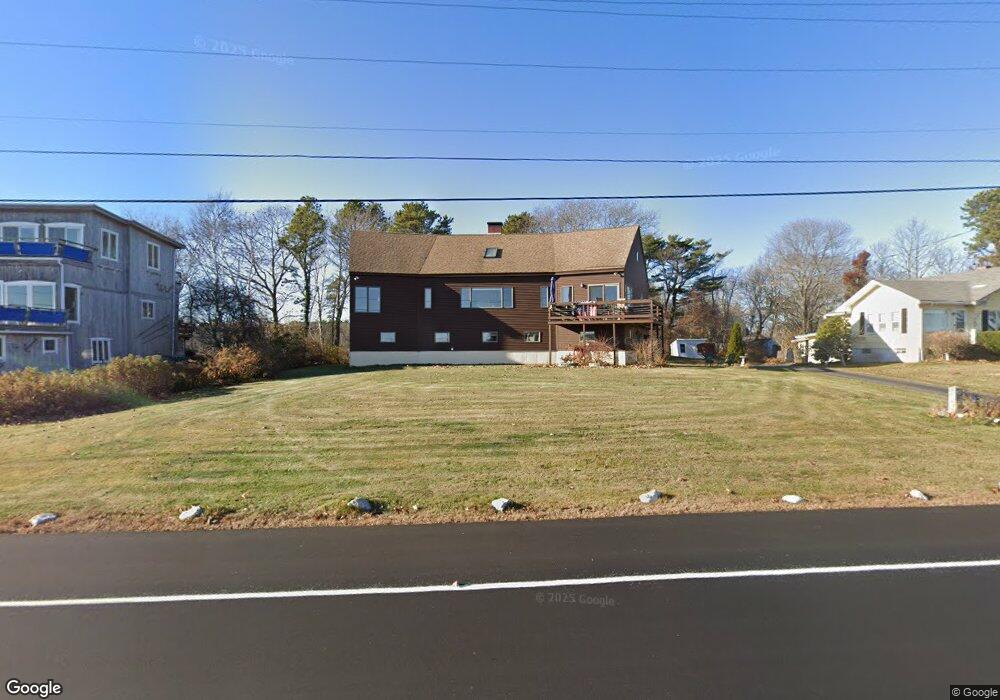
This home is located at 771 Ocean Blvd, Rye, NH 03870 and is currently estimated at $1,599,564, approximately $672 per square foot. 771 Ocean Blvd is a home located in Rockingham County with nearby schools including Rye Elementary School, Rye Junior High School, and St Patrick School.
Ownership History
Date
Name
Owned For
Owner Type
Purchase Details
Closed on
Jun 27, 2023
Sold by
Rawding Williams S and Rawding Elizabeth A
Bought by
Rawding Ft and Rawding
Current Estimated Value
Purchase Details
Closed on
Jun 4, 2013
Sold by
White John J
Bought by
Rawding William S and Rawding Elizabeth A
Create a Home Valuation Report for This Property
The Home Valuation Report is an in-depth analysis detailing your home's value as well as a comparison with similar homes in the area
Home Values in the Area
Average Home Value in this Area
Purchase History
| Date | Buyer | Sale Price | Title Company |
|---|---|---|---|
| Rawding Ft | -- | None Available | |
| Rawding Ft | -- | None Available | |
| Rawding Ft | -- | None Available | |
| Rawding William S | $670,000 | -- | |
| Rawding William S | -- | -- | |
| Rawding William S | -- | -- |
Source: Public Records
Mortgage History
| Date | Status | Borrower | Loan Amount |
|---|---|---|---|
| Closed | Rawding William S | $0 |
Source: Public Records
Tax History
| Year | Tax Paid | Tax Assessment Tax Assessment Total Assessment is a certain percentage of the fair market value that is determined by local assessors to be the total taxable value of land and additions on the property. | Land | Improvement |
|---|---|---|---|---|
| 2024 | $11,040 | $1,274,800 | $994,800 | $280,000 |
| 2023 | $10,237 | $1,274,800 | $994,800 | $280,000 |
| 2022 | $8,898 | $1,274,800 | $994,800 | $280,000 |
| 2021 | $10,236 | $1,001,600 | $778,300 | $223,300 |
| 2020 | $10,277 | $1,001,600 | $778,300 | $223,300 |
| 2019 | $10,208 | $998,800 | $778,300 | $220,500 |
| 2018 | $6,329 | $998,800 | $778,300 | $220,500 |
| 2017 | $10,098 | $998,800 | $778,300 | $220,500 |
| 2016 | $8,735 | $817,900 | $628,900 | $189,000 |
| 2013 | $8,427 | $768,200 | $643,400 | $124,800 |
Source: Public Records
Map
Nearby Homes
- 763 Ocean Blvd
- 267 Pioneer Rd
- 1193 Ocean Blvd
- 1215 Ocean Blvd Unit 5
- 236 Sagamore Rd
- 137 Clark Rd
- 46 Fowler Dr
- 75 Marina Heights Rd
- 14 Sagamore Rd Unit 3
- 4 Sagamore Rd
- 389 Sagamore Rd
- 104 Odiorne Point Rd
- 1155 Sagamore Ave Unit 2
- 239 Gosport Rd
- 18 Mainmast Cir
- 1191 - 1193 Ocean Blvd
- 1591 Ocean Blvd
- 24 Seabreeze Ln
- 1643 Ocean Blvd
- 665 Wallis Rd Unit 2
- 777 Ocean Blvd
- 785 Ocean Blvd
- 767 Ocean Blvd
- 14 Pollock Dr
- 10 Pollock Dr
- 789 Ocean Blvd
- 789 Ocean Blvd Unit 1
- 753 Ocean Blvd
- 22 Pollock Dr
- 795 Ocean Blvd
- 28 Pollock Dr
- 747 Ocean Blvd Unit 1
- 747 Ocean Blvd Unit 11
- 747 Ocean Blvd Unit 2
- 747 Ocean Blvd
- 784 Ocean Blvd Unit 2
- 784 Ocean Blvd Unit 15
- 784 Ocean Blvd Unit 14
- 784 Ocean Blvd Unit 12
- 784 Ocean Blvd Unit 11
Your Personal Tour Guide
Ask me questions while you tour the home.