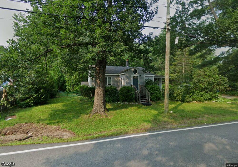
772 Hooksett Rd Auburn, NH 03032
Estimated Value: $387,079 - $534,000
2
Beds
2
Baths
1,041
Sq Ft
$418/Sq Ft
Est. Value
About This Home
This home is located at 772 Hooksett Rd, Auburn, NH 03032 and is currently estimated at $435,270, approximately $418 per square foot. 772 Hooksett Rd is a home located in Rockingham County with nearby schools including Auburn Village School, Pinkerton Academy, and Auburn Montessori School.
Ownership History
Date
Name
Owned For
Owner Type
Purchase Details
Closed on
Jun 30, 1999
Sold by
Cote Edward B
Bought by
Arguropoulos Elene D
Current Estimated Value
Home Financials for this Owner
Home Financials are based on the most recent Mortgage that was taken out on this home.
Original Mortgage
$67,600
Outstanding Balance
$16,977
Interest Rate
7.19%
Estimated Equity
$418,293
Create a Home Valuation Report for This Property
The Home Valuation Report is an in-depth analysis detailing your home's value as well as a comparison with similar homes in the area
Home Values in the Area
Average Home Value in this Area
Purchase History
| Date | Buyer | Sale Price | Title Company |
|---|---|---|---|
| Arguropoulos Elene D | $84,500 | -- |
Source: Public Records
Mortgage History
| Date | Status | Borrower | Loan Amount |
|---|---|---|---|
| Open | Arguropoulos Elene D | $67,600 |
Source: Public Records
Tax History
| Year | Tax Paid | Tax Assessment Tax Assessment Total Assessment is a certain percentage of the fair market value that is determined by local assessors to be the total taxable value of land and additions on the property. | Land | Improvement |
|---|---|---|---|---|
| 2025 | $4,540 | $327,100 | $190,300 | $136,800 |
| 2024 | $4,406 | $327,100 | $190,300 | $136,800 |
| 2023 | $4,125 | $327,100 | $190,300 | $136,800 |
| 2022 | $4,059 | $227,400 | $148,200 | $79,200 |
| 2021 | $4,125 | $227,400 | $148,200 | $79,200 |
| 2020 | $4,202 | $227,400 | $148,200 | $79,200 |
| 2019 | $4,289 | $228,000 | $148,200 | $79,800 |
| 2018 | $531 | $228,000 | $148,200 | $79,800 |
| 2017 | $4,054 | $191,700 | $144,200 | $47,500 |
| 2016 | $5,368 | $191,700 | $144,200 | $47,500 |
| 2015 | $3,970 | $191,700 | $144,200 | $47,500 |
| 2014 | $4,085 | $191,700 | $144,200 | $47,500 |
| 2013 | $3,755 | $191,700 | $144,200 | $47,500 |
Source: Public Records
Map
Nearby Homes
- 10 Harvard Ave
- 14 Overlook Cir
- 22 Sunrise Cir
- 15 Joanne Dr
- 192 Londonderry Turnpike
- 36 Prescott Heights Rd
- 100 Dartmouth Dr
- 13 Johns Dr
- 80 Dartmouth Dr
- 267 Londonderry Turnpike
- 52 the Cliffs at Evergreen Dr
- 135 Brookview Dr
- 55 the Cliffs at Evergreen Cliffside Dr Unit 55
- 47 the Cliffs at Evergreen Cliffside Dr Unit 47
- 11 Rockingham Rd Unit H
- 286 Londonderry Turnpike Unit A
- 286B Londonderry Turnpike Unit A
- 41 Golden Gate Dr
- 2079 Wellington Rd
- 199 Whitehall Rd
- 786 Hooksett Rd
- 767 Hooksett Rd
- 789 Hooksett Rd
- 757 Hooksett Rd
- 760 Hooksett Rd
- 120 Heather Cir
- 792 Hooksett Rd
- 22 Squirrel Dr
- 19 Squirrel Dr
- 110 Heather Cir
- 752 Hooksett Rd
- 30 Heather Cir
- 797 Hooksett Rd
- 33 Heather Cir
- 740 Hooksett Rd
- 109 Heather Cir
- 32 Squirrel Dr
- 745 Hooksett Rd
- 34 Squirrel Dr
- 102 Heather Cir
Your Personal Tour Guide
Ask me questions while you tour the home.