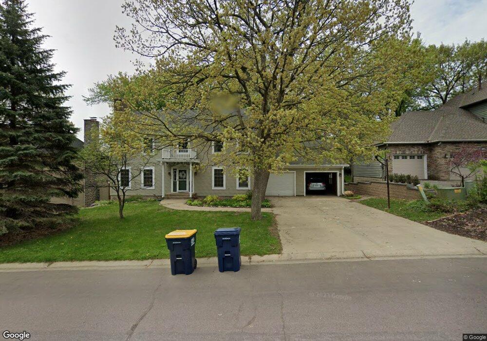
7720 133rd St W Saint Paul, MN 55124
Alimagnet NeighborhoodEstimated Value: $544,283 - $597,000
5
Beds
4
Baths
3,380
Sq Ft
$168/Sq Ft
Est. Value
About This Home
This home is located at 7720 133rd St W, Saint Paul, MN 55124 and is currently estimated at $568,571, approximately $168 per square foot. 7720 133rd St W is a home located in Dakota County with nearby schools including Westview Elementary School, Falcon Ridge Middle School, and Apple Valley Senior High School.
Ownership History
Date
Name
Owned For
Owner Type
Purchase Details
Closed on
Feb 22, 2022
Sold by
Opendoor Property Trust I A Delaware St
Bought by
Matter Rianna and Matter Christopher
Current Estimated Value
Home Financials for this Owner
Home Financials are based on the most recent Mortgage that was taken out on this home.
Original Mortgage
$488,000
Outstanding Balance
$453,145
Interest Rate
3.55%
Mortgage Type
New Conventional
Estimated Equity
$115,426
Purchase Details
Closed on
Sep 20, 2021
Sold by
Scheerz Roger D and Scheerz Deborah Kay
Bought by
Opendoor Property Trust I
Create a Home Valuation Report for This Property
The Home Valuation Report is an in-depth analysis detailing your home's value as well as a comparison with similar homes in the area
Home Values in the Area
Average Home Value in this Area
Purchase History
| Date | Buyer | Sale Price | Title Company |
|---|---|---|---|
| Matter Rianna | $488,000 | -- | |
| Opendoor Property Trust I | $483,100 | Os National Llc |
Source: Public Records
Mortgage History
| Date | Status | Borrower | Loan Amount |
|---|---|---|---|
| Open | Matter Rianna | $488,000 |
Source: Public Records
Tax History Compared to Growth
Tax History
| Year | Tax Paid | Tax Assessment Tax Assessment Total Assessment is a certain percentage of the fair market value that is determined by local assessors to be the total taxable value of land and additions on the property. | Land | Improvement |
|---|---|---|---|---|
| 2024 | $5,746 | $492,900 | $119,400 | $373,500 |
| 2023 | $5,746 | $505,400 | $119,600 | $385,800 |
| 2022 | $4,860 | $491,500 | $119,300 | $372,200 |
| 2021 | $4,704 | $417,300 | $103,700 | $313,600 |
| 2020 | $4,782 | $396,200 | $98,800 | $297,400 |
| 2019 | $4,501 | $390,800 | $94,100 | $296,700 |
| 2018 | $4,276 | $384,400 | $89,600 | $294,800 |
| 2017 | $4,410 | $351,300 | $85,300 | $266,000 |
| 2016 | $4,494 | $343,900 | $81,200 | $262,700 |
| 2015 | $4,235 | $340,009 | $78,297 | $261,712 |
| 2014 | -- | $322,351 | $75,043 | $247,308 |
| 2013 | -- | $287,798 | $68,523 | $219,275 |
Source: Public Records
Map
Nearby Homes
- 13420 Gull Ct
- 13199 Gemstone Ct
- 13715 Grafton Ct
- 7577 138th St W
- 13868 Glendale Ct
- 13720 Georgia Dr
- 12867 Pennock Ave
- 7291 Upper 136th St W
- 14010 140th Ct
- 7342 Upper 139th St W
- 7090 Gardenia Ct
- 13101 Heritage Way
- 13780 Hanover Way
- 13135 Gamma Way
- 110 Pony Ln E
- 14080 Guthrie Ave
- 13902 Herald Way
- 13910 Herald Ct
- 13345 Huntington Cir
- 6790 132nd St W
- 7702 133rd St W
- 7734 133rd St W
- 13349 Granada Ave
- 13350 Pennock Ave
- 13350 Pennock Ave
- 7717 133rd St W
- 7733 133rd St W
- 7699 133rd St W
- 13370 Pennock Ave
- 13369 Granada Ave
- 13330 Granada Ave
- 7760 133rd St W
- 7683 133rd St W
- 13350 Granada Ave
- 7755 134th St W
- 7765 133rd St W
- 13390 Pennock Ave
- 13389 Granada Ave
- 7665 133rd St W
- 13370 Granada Ave