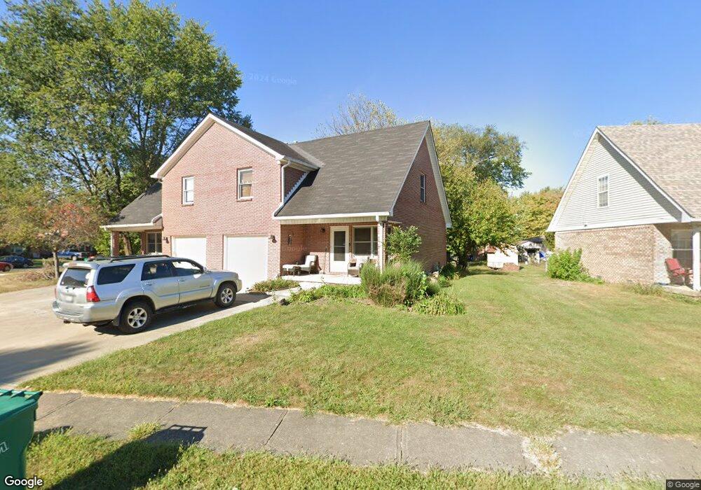
773 Maple Ln Brownsburg, IN 46112
Estimated Value: $232,684 - $374,000
3
Beds
3
Baths
3,183
Sq Ft
$91/Sq Ft
Est. Value
About This Home
This home is located at 773 Maple Ln, Brownsburg, IN 46112 and is currently estimated at $290,671, approximately $91 per square foot. 773 Maple Ln is a home located in Hendricks County with nearby schools including Brown Elementary School, Brownsburg West Middle School, and Brownsburg High School.
Ownership History
Date
Name
Owned For
Owner Type
Purchase Details
Closed on
Dec 30, 2020
Sold by
Brooks Douglas J and Brooks Regina A
Bought by
Brook Rental Llc
Current Estimated Value
Purchase Details
Closed on
Nov 14, 2014
Sold by
Huglin Russel K and Huglin Elizabeth L
Bought by
Brooks Douglas J and Brooks Regina A
Home Financials for this Owner
Home Financials are based on the most recent Mortgage that was taken out on this home.
Original Mortgage
$131,250
Interest Rate
3.97%
Mortgage Type
New Conventional
Create a Home Valuation Report for This Property
The Home Valuation Report is an in-depth analysis detailing your home's value as well as a comparison with similar homes in the area
Home Values in the Area
Average Home Value in this Area
Purchase History
| Date | Buyer | Sale Price | Title Company |
|---|---|---|---|
| Brook Rental Llc | -- | None Available | |
| Brooks Douglas J | -- | -- |
Source: Public Records
Mortgage History
| Date | Status | Borrower | Loan Amount |
|---|---|---|---|
| Previous Owner | Brooks Douglas J | $131,250 |
Source: Public Records
Tax History
| Year | Tax Paid | Tax Assessment Tax Assessment Total Assessment is a certain percentage of the fair market value that is determined by local assessors to be the total taxable value of land and additions on the property. | Land | Improvement |
|---|---|---|---|---|
| 2025 | $3,906 | $195,300 | $21,400 | $173,900 |
| 2024 | $3,906 | $195,300 | $23,400 | $171,900 |
| 2023 | $3,906 | $195,300 | $22,800 | $172,500 |
| 2022 | $3,198 | $159,900 | $18,100 | $141,800 |
| 2021 | $2,624 | $131,200 | $16,900 | $114,300 |
| 2020 | $2,624 | $131,200 | $17,800 | $113,400 |
| 2019 | $3,888 | $194,400 | $26,200 | $168,200 |
| 2018 | $3,328 | $166,400 | $23,700 | $142,700 |
| 2017 | $3,328 | $166,400 | $23,800 | $142,600 |
| 2016 | $3,328 | $166,400 | $24,500 | $141,900 |
| 2014 | $3,448 | $172,400 | $24,600 | $147,800 |
| 2013 | $3,484 | $174,200 | $24,600 | $149,600 |
Source: Public Records
Map
Nearby Homes
- 638 Maple Ct
- 529 Maple Ln
- 867 Ironwood West Dr
- 9937 Us Highway 136
- 390 Vinewood Dr N
- 635 Jackson St
- 1045 Lakewood South Dr
- 1108 Redwood Dr
- 645 E Main St
- 17 Roselawn Ave
- 212 Hamilton St
- 106 S Grant St
- 509 E Main St
- 252 N Odell St
- 448 Murphy Ln
- 1313 S Odell St
- 4475 Yellowwood Ave
- 4472 Yellowwood Ave
- 4494 Yellowwood Ave
- 6275 Lewis St
Your Personal Tour Guide
Ask me questions while you tour the home.