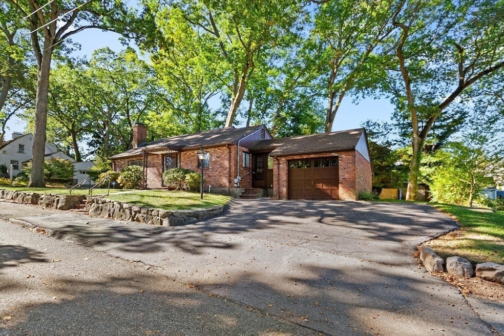
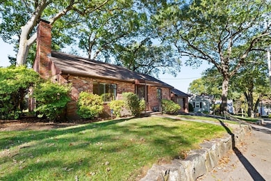
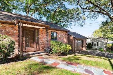
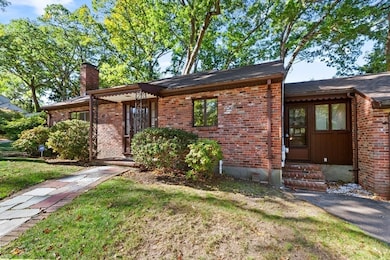
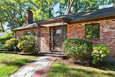
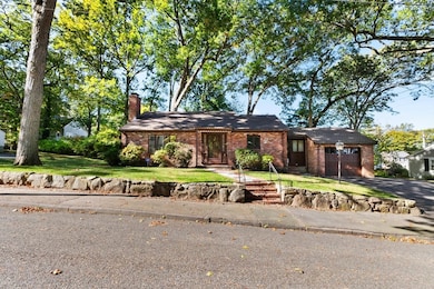
78 Windemere Cir Braintree, MA 02184
North Braintree NeighborhoodEstimated payment $4,174/month
Highlights
- Popular Property
- Family Room with Fireplace
- Wood Flooring
- Custom Closet System
- Ranch Style House
- Bonus Room
About This Home
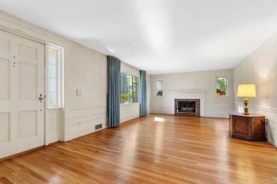
Welcome Home to 78 Windemere Circle. Beautifully maintained 2-bedroom, 2-bath ranch with one-car garage on a generous 11,238 sq. ft. lot in the sought-after Braintree square area. Features include a spacious living room with fireplace that opens to the kitchen, a welcoming layout, and potential for expansion. Located near Thayer Academy with easy highway access, top shopping and dining, and commuter rail to Boston. Ready for its next chapter.
Open House Schedule
-
Sunday, November 16, 202511:30 am to 1:00 pm11/16/2025 11:30:00 AM +00:0011/16/2025 1:00:00 PM +00:00Add to Calendar
Home Details
Home Type
- Single Family
Est. Annual Taxes
- $7,139
Year Built
- Built in 1950
Lot Details
- 0.26 Acre Lot
- Gentle Sloping Lot
Parking
- 1 Car Attached Garage
- Driveway
- Open Parking
Home Design
- Ranch Style House
- Shingle Roof
- Concrete Perimeter Foundation
Interior Spaces
- Family Room with Fireplace
- 2 Fireplaces
- Living Room with Fireplace
- Bonus Room
- Partially Finished Basement
Kitchen
- Range
- Dishwasher
Flooring
- Wood
- Laminate
- Vinyl
Bedrooms and Bathrooms
- 2 Bedrooms
- Custom Closet System
- 2 Full Bathrooms
Utilities
- Forced Air Heating and Cooling System
- Heating System Uses Natural Gas
Additional Features
- Bulkhead
- Property is near schools
Community Details
- No Home Owners Association
- Shops
Listing and Financial Details
- Assessor Parcel Number M:2036 B:0 L:75,19032
Map
Home Values in the Area
Average Home Value in this Area
Tax History
| Year | Tax Paid | Tax Assessment Tax Assessment Total Assessment is a certain percentage of the fair market value that is determined by local assessors to be the total taxable value of land and additions on the property. | Land | Improvement |
|---|---|---|---|---|
| 2025 | $7,139 | $715,300 | $409,400 | $305,900 |
| 2024 | $6,508 | $686,500 | $385,000 | $301,500 |
| 2023 | $6,013 | $616,100 | $331,400 | $284,700 |
| 2022 | $5,742 | $577,100 | $292,400 | $284,700 |
| 2021 | $5,595 | $562,300 | $294,400 | $267,900 |
| 2020 | $5,544 | $562,300 | $294,400 | $267,900 |
| 2019 | $5,251 | $520,400 | $280,700 | $239,700 |
| 2018 | $4,801 | $455,500 | $224,200 | $231,300 |
| 2017 | $4,745 | $441,800 | $210,500 | $231,300 |
| 2016 | $4,791 | $436,300 | $210,500 | $225,800 |
| 2015 | $4,830 | $436,300 | $210,500 | $225,800 |
| 2014 | $4,203 | $368,000 | $183,300 | $184,700 |
Property History
| Date | Event | Price | List to Sale | Price per Sq Ft |
|---|---|---|---|---|
| 11/14/2025 11/14/25 | Price Changed | $679,000 | -5.6% | $344 / Sq Ft |
| 10/20/2025 10/20/25 | Price Changed | $718,900 | -2.7% | $364 / Sq Ft |
| 10/10/2025 10/10/25 | For Sale | $739,000 | -- | $374 / Sq Ft |
Purchase History
| Date | Type | Sale Price | Title Company |
|---|---|---|---|
| Quit Claim Deed | -- | None Available | |
| Quit Claim Deed | -- | None Available | |
| Deed | -- | -- |
Source: MLS Property Information Network (MLS PIN)
MLS Number: 73442333
APN: BRAI-002036-000000-000075
Disclaimer: Certain information contained herein is derived from information provided by parties other than Homes.com. All information provided is deemed reliable, but is not guaranteed to be accurate and should be independently verified.
![]() The property listing data and information, or the Images, set forth herein were provided to MLS Property Information Network, Inc. from third party sources, including sellers, lessors and public records, and were compiled by MLS Property Information Network, Inc. The property listing data and information, and the Images, are for the personal, non-commercial use of consumers having a good faith interest in purchasing or leasing listed properties of the type displayed to them and may not be used for any purpose other than to identify prospective properties which such consumers may have a good faith interest in purchasing or leasing. MLS Property Information Network, Inc. and its subscribers disclaim any and all representations and warranties as to the accuracy of the property listing data and information, or as to the accuracy of any of the Images, set forth herein.
The property listing data and information, or the Images, set forth herein were provided to MLS Property Information Network, Inc. from third party sources, including sellers, lessors and public records, and were compiled by MLS Property Information Network, Inc. The property listing data and information, and the Images, are for the personal, non-commercial use of consumers having a good faith interest in purchasing or leasing listed properties of the type displayed to them and may not be used for any purpose other than to identify prospective properties which such consumers may have a good faith interest in purchasing or leasing. MLS Property Information Network, Inc. and its subscribers disclaim any and all representations and warranties as to the accuracy of the property listing data and information, or as to the accuracy of any of the Images, set forth herein.
- 17 Judson St
- 53 Parkside Ave
- 175 West St
- 37 Monatiquot Ave
- 63 Dickerman Ln
- 29 Norton St
- 305 Franklin St
- 8 Vinton Ave Unit 10
- 47 Addison St
- 161 Cedar St
- 9 Independence Ave Unit 105
- 146 Eleanor Dr
- 195 Independence Ave Unit 137
- 65 Tremont St
- 106 Home Park Rd
- 39 Lawnview Dr
- 347 Centre St
- 54 Elmlawn Rd
- 21 Totman St Unit 204
- 21 Totman St Unit 309
- 550 Washington St Unit 303
- 550 Washington St Unit 107
- 550 Washington St Unit 112
- 26 Reed Hill Rd
- 15 Weston Ct Unit 4
- 22 Weston Ave Unit 3
- 370 Franklin St
- 173 Elm St Unit 2
- 648 Washington St Unit 2A
- 7 Crown Dr
- 50 Union Place Unit 50
- 167 Middle St Unit 2
- 766 Washington St
- 195 Independence Ave Unit 118
- 47 Tremont St Unit 2nd
- 59 Tremont St Unit 1
- 20 Rockdale St
- 31-33 Tremont St Unit 1
- 362 Centre St Unit 1
- 362 Centre St Unit 4
