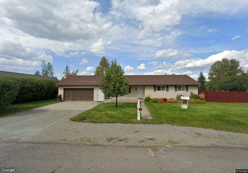
780 Tenneson Rd Helena, MT 59602
West Helena Valley NeighborhoodEstimated Value: $355,000 - $483,000
3
Beds
2
Baths
1,232
Sq Ft
$341/Sq Ft
Est. Value
About This Home
This home is located at 780 Tenneson Rd, Helena, MT 59602 and is currently estimated at $420,247, approximately $341 per square foot. 780 Tenneson Rd is a home located in Lewis and Clark County with nearby schools including Four Georgians Elementary School, C.R. Anderson Middle School, and Calvary Christian School.
Ownership History
Date
Name
Owned For
Owner Type
Purchase Details
Closed on
Mar 9, 2007
Sold by
Riley David L and Riley Elizabeth J
Bought by
Maynard Michael J and Maynard Carol L
Current Estimated Value
Home Financials for this Owner
Home Financials are based on the most recent Mortgage that was taken out on this home.
Original Mortgage
$175,600
Outstanding Balance
$106,114
Interest Rate
6.23%
Mortgage Type
New Conventional
Estimated Equity
$314,133
Create a Home Valuation Report for This Property
The Home Valuation Report is an in-depth analysis detailing your home's value as well as a comparison with similar homes in the area
Home Values in the Area
Average Home Value in this Area
Purchase History
| Date | Buyer | Sale Price | Title Company |
|---|---|---|---|
| Maynard Michael J | -- | First Montana Title Company |
Source: Public Records
Mortgage History
| Date | Status | Borrower | Loan Amount |
|---|---|---|---|
| Open | Maynard Michael J | $175,600 |
Source: Public Records
Tax History Compared to Growth
Tax History
| Year | Tax Paid | Tax Assessment Tax Assessment Total Assessment is a certain percentage of the fair market value that is determined by local assessors to be the total taxable value of land and additions on the property. | Land | Improvement |
|---|---|---|---|---|
| 2025 | $1,785 | $395,300 | $0 | $0 |
| 2024 | $2,803 | $341,200 | $0 | $0 |
| 2023 | $2,998 | $341,200 | $0 | $0 |
| 2022 | $2,586 | $247,200 | $0 | $0 |
| 2021 | $2,363 | $247,200 | $0 | $0 |
| 2020 | $2,522 | $236,900 | $0 | $0 |
| 2019 | $2,541 | $236,900 | $0 | $0 |
| 2018 | $2,308 | $210,700 | $0 | $0 |
| 2017 | $1,813 | $210,700 | $0 | $0 |
| 2016 | $1,899 | $202,700 | $0 | $0 |
| 2015 | $1,783 | $202,700 | $0 | $0 |
| 2014 | $1,669 | $104,039 | $0 | $0 |
Source: Public Records
Map
Nearby Homes
- 1010 Motsiff Rd
- 1030 Motsiff Rd
- 630 Stadler Rd
- 4350 N Montana Ave Unit 5
- 4324 N Montana Ave
- 4435 Woodchuck Dr
- 4506 Porcupine Dr
- 5420 Robin Dr
- 5530 N Montana Ave
- 3960 Canal Dr
- 1344 Beaverhead Rd
- 5277 Glacier Point Loop
- 5288 Glacier Point Loop
- 835 Onyx Place
- 845 Faw Rd
- 4015 Green Meadow Dr
- 1650 Karmen Rd
- 885 Amethyst Ave
- 769 Insulator Ave
- 322 Andesite Ave Unit A and B