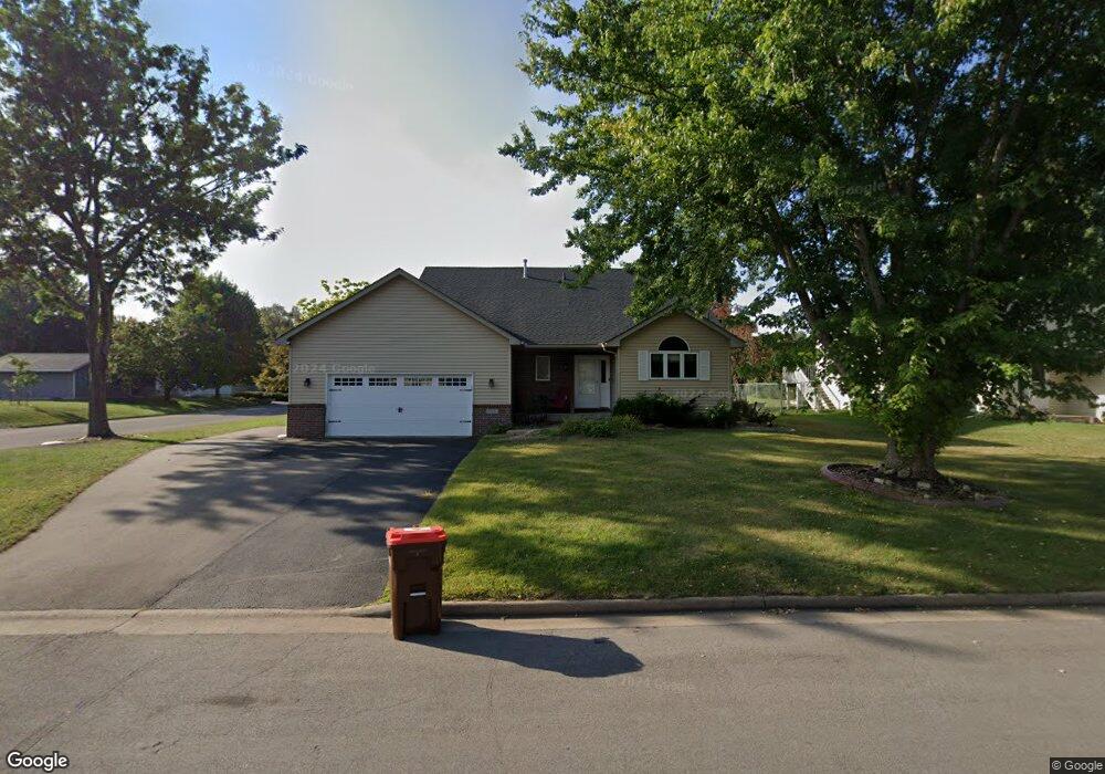
785 Laura St Prescott, WI 54021
Estimated Value: $347,000 - $369,000
4
Beds
3
Baths
--
Sq Ft
0.25
Acres
About This Home
This home is located at 785 Laura St, Prescott, WI 54021 and is currently estimated at $357,266. 785 Laura St is a home located in Pierce County with nearby schools including Malone Elementary School, Prescott Middle School, and Prescott High School.
Ownership History
Date
Name
Owned For
Owner Type
Purchase Details
Closed on
Jun 14, 2017
Sold by
Randolph Travis D and Randolph Brittany J
Bought by
Carlson Suzanne M
Current Estimated Value
Home Financials for this Owner
Home Financials are based on the most recent Mortgage that was taken out on this home.
Original Mortgage
$165,000
Interest Rate
4.6%
Mortgage Type
New Conventional
Purchase Details
Closed on
Jun 30, 2015
Sold by
Huppert Lee M and Huppert Brandi L
Bought by
Randolph Travis D and Randolph Brittany J
Home Financials for this Owner
Home Financials are based on the most recent Mortgage that was taken out on this home.
Original Mortgage
$198,550
Interest Rate
3.83%
Mortgage Type
New Conventional
Create a Home Valuation Report for This Property
The Home Valuation Report is an in-depth analysis detailing your home's value as well as a comparison with similar homes in the area
Home Values in the Area
Average Home Value in this Area
Purchase History
| Date | Buyer | Sale Price | Title Company |
|---|---|---|---|
| Carlson Suzanne M | $230,000 | None Available | |
| Randolph Travis D | $209,000 | None Available |
Source: Public Records
Mortgage History
| Date | Status | Borrower | Loan Amount |
|---|---|---|---|
| Previous Owner | Carlson Suzanne M | $165,000 | |
| Previous Owner | Randolph Travis D | $198,550 |
Source: Public Records
Tax History Compared to Growth
Tax History
| Year | Tax Paid | Tax Assessment Tax Assessment Total Assessment is a certain percentage of the fair market value that is determined by local assessors to be the total taxable value of land and additions on the property. | Land | Improvement |
|---|---|---|---|---|
| 2024 | $5,390 | $304,900 | $57,100 | $247,800 |
| 2023 | $5,221 | $304,900 | $57,100 | $247,800 |
| 2022 | $4,845 | $210,700 | $32,700 | $178,000 |
| 2021 | $4,745 | $210,700 | $32,700 | $178,000 |
| 2020 | $4,855 | $210,700 | $32,700 | $178,000 |
| 2019 | $4,844 | $210,700 | $32,700 | $178,000 |
| 2018 | $4,632 | $210,700 | $32,700 | $178,000 |
| 2017 | $5,329 | $210,700 | $32,700 | $178,000 |
| 2016 | $4,623 | $185,300 | $32,700 | $152,600 |
| 2015 | $4,792 | $185,300 | $32,700 | $152,600 |
| 2014 | $4,630 | $185,300 | $32,700 | $152,600 |
| 2013 | $4,356 | $185,300 | $32,700 | $152,600 |
Source: Public Records
Map
Nearby Homes
- 568 Locust St S
- 170 Mississippi St
- 368 Young St S
- 170 Tower Rd
- 284 Elm St S
- 565 Pleasant Dr
- 150 Front St N Unit 421
- 150 Front St N Unit 323
- 580 Northern Lights Dr
- 525 Linn St N
- 1433 Glenridge Dr
- 155 Linden Rd
- 482 Delta Queen Ave
- The Washington Plan at Great Rivers
- The Waterford Plan at Great Rivers
- The Summit Plan at Great Rivers
- The Madison Plan at Great Rivers
- The Madison Villa Plan at Great Rivers
- The Maplewood Plan at Great Rivers
- The Somerset Plan at Great Rivers
- 464 Warren St
- 476 Warren St
- 739 Laura St
- 735 Laura St
- 912 Washington St
- 940 Washington St
- 885 Laura St
- 871 Laura St
- 860 Washington St
- 680 Laura St
- 977 Washington St
- 951 Washington St
- 365 Lawrence St
- 190 Lawrence St
- 887 Jefferson St
- 851 Jefferson St
- 857 Jefferson St
- 761 Jefferson St
- 757 Jefferson St
- 677 Jefferson St