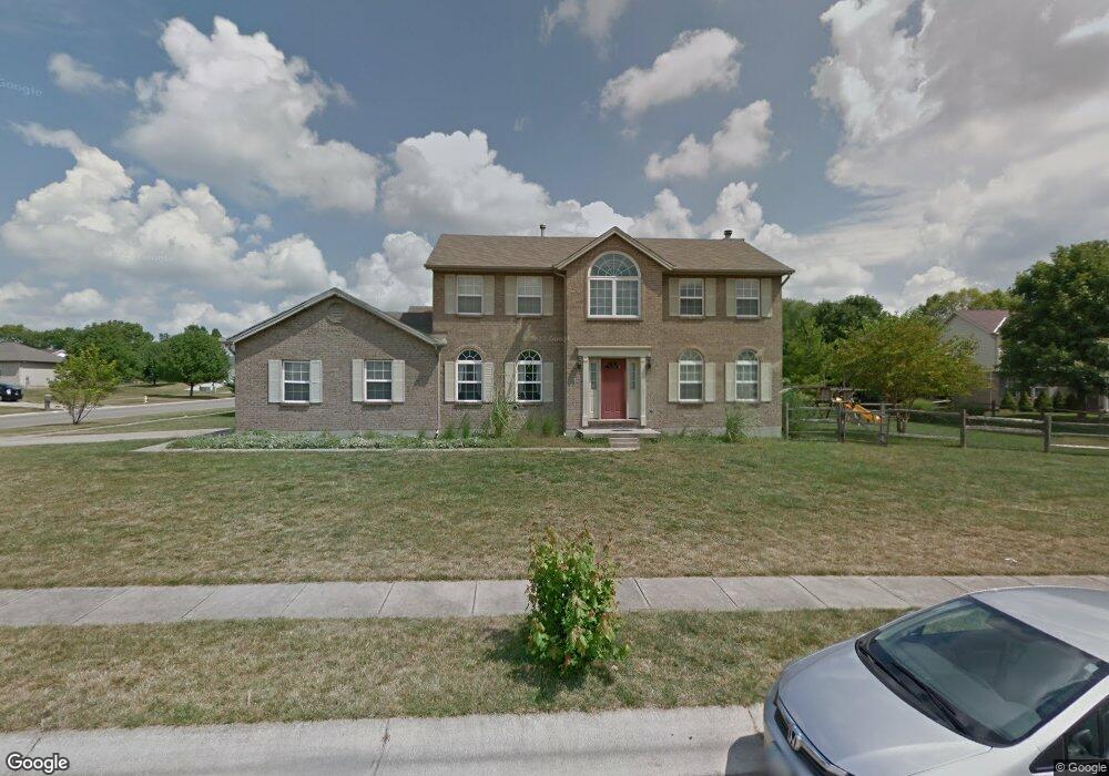
7855 Seward Rd Fairfield, OH 45011
Estimated Value: $387,000 - $477,000
4
Beds
3
Baths
2,316
Sq Ft
$181/Sq Ft
Est. Value
About This Home
This home is located at 7855 Seward Rd, Fairfield, OH 45011 and is currently estimated at $418,427, approximately $180 per square foot. 7855 Seward Rd is a home located in Butler County with nearby schools including Compass Elementary School, Creekside Middle School, and Fairfield Senior High School.
Ownership History
Date
Name
Owned For
Owner Type
Purchase Details
Closed on
Nov 21, 1998
Sold by
Laster Clarence Todd and Lester Della Anita
Bought by
Lindeman Eric J and Lindeman Jennifer Lynn
Current Estimated Value
Home Financials for this Owner
Home Financials are based on the most recent Mortgage that was taken out on this home.
Original Mortgage
$126,000
Interest Rate
6.83%
Mortgage Type
Purchase Money Mortgage
Purchase Details
Closed on
Nov 4, 1996
Sold by
Dixon Builder & Develope
Bought by
Laster Clarence T
Home Financials for this Owner
Home Financials are based on the most recent Mortgage that was taken out on this home.
Original Mortgage
$134,400
Interest Rate
8.23%
Mortgage Type
New Conventional
Create a Home Valuation Report for This Property
The Home Valuation Report is an in-depth analysis detailing your home's value as well as a comparison with similar homes in the area
Home Values in the Area
Average Home Value in this Area
Purchase History
| Date | Buyer | Sale Price | Title Company |
|---|---|---|---|
| Lindeman Eric J | $157,500 | -- | |
| Laster Clarence T | $141,500 | -- |
Source: Public Records
Mortgage History
| Date | Status | Borrower | Loan Amount |
|---|---|---|---|
| Previous Owner | Lindeman Eric J | $126,000 | |
| Previous Owner | Laster Clarence T | $134,400 |
Source: Public Records
Tax History Compared to Growth
Tax History
| Year | Tax Paid | Tax Assessment Tax Assessment Total Assessment is a certain percentage of the fair market value that is determined by local assessors to be the total taxable value of land and additions on the property. | Land | Improvement |
|---|---|---|---|---|
| 2024 | $4,472 | $121,400 | $14,770 | $106,630 |
| 2023 | $4,450 | $121,420 | $14,770 | $106,650 |
| 2022 | $3,808 | $79,750 | $14,770 | $64,980 |
| 2021 | $3,291 | $78,480 | $14,770 | $63,710 |
| 2020 | $3,424 | $78,480 | $14,770 | $63,710 |
| 2019 | $5,486 | $63,540 | $14,500 | $49,040 |
| 2018 | $3,149 | $63,540 | $14,500 | $49,040 |
| 2017 | $3,180 | $63,540 | $14,500 | $49,040 |
| 2016 | $2,985 | $56,780 | $14,500 | $42,280 |
| 2015 | $2,842 | $56,780 | $14,500 | $42,280 |
| 2014 | $2,685 | $56,780 | $14,500 | $42,280 |
| 2013 | $2,685 | $56,310 | $15,260 | $41,050 |
Source: Public Records
Map
Nearby Homes
- 7587 Vinnedge Rd
- 7920 Jessies Way
- 7918 Jessies Way
- 7918 Jessies Way Unit 304
- 7912 Jessies Way
- 4101 Jamie Dr
- 7903 Jessies Way Unit 21-304
- 7795 Rock Port Way
- 7397 Chateauguay Dr
- 7301 Dixon Dr
- 4210 Tylers Estates Dr
- 4257 Primary Colors
- 4387 Tylers Estates Dr
- 4401 E Observatory
- 4224 College Dictionary
- 7075 Ashwood Knolls Dr
- 4212 R E Smith Dr
- 7611 Tylers Hill Ct
- 8024 Seabury Ct
- 8129 S Port Dr