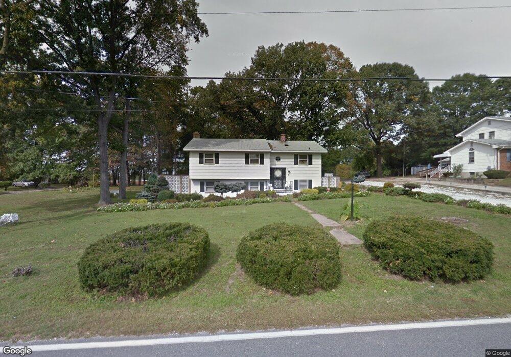
786 Queenstown Rd Severn, MD 21144
Estimated Value: $276,000 - $445,550
4
Beds
2
Baths
1,961
Sq Ft
$183/Sq Ft
Est. Value
About This Home
This home is located at 786 Queenstown Rd, Severn, MD 21144 and is currently estimated at $358,888, approximately $183 per square foot. 786 Queenstown Rd is a home located in Anne Arundel County with nearby schools including Severn Elementary School, Old Mill Middle School North, and Old Mill High School.
Ownership History
Date
Name
Owned For
Owner Type
Purchase Details
Closed on
Oct 29, 2021
Sold by
Raymond Blackstone
Bought by
Blackstone Rodney and Consavella Thomas
Current Estimated Value
Home Financials for this Owner
Home Financials are based on the most recent Mortgage that was taken out on this home.
Original Mortgage
$162,697
Interest Rate
3.01%
Mortgage Type
FHA
Create a Home Valuation Report for This Property
The Home Valuation Report is an in-depth analysis detailing your home's value as well as a comparison with similar homes in the area
Home Values in the Area
Average Home Value in this Area
Purchase History
| Date | Buyer | Sale Price | Title Company |
|---|---|---|---|
| Blackstone Rodney | $166,615 | Absolute Title |
Source: Public Records
Mortgage History
| Date | Status | Borrower | Loan Amount |
|---|---|---|---|
| Previous Owner | Blackstone Rodney | $162,697 |
Source: Public Records
Tax History Compared to Growth
Tax History
| Year | Tax Paid | Tax Assessment Tax Assessment Total Assessment is a certain percentage of the fair market value that is determined by local assessors to be the total taxable value of land and additions on the property. | Land | Improvement |
|---|---|---|---|---|
| 2025 | $3,292 | $265,300 | $106,800 | $158,500 |
| 2024 | $3,292 | $254,800 | $0 | $0 |
| 2023 | $3,141 | $244,300 | $0 | $0 |
| 2022 | $2,873 | $233,800 | $94,300 | $139,500 |
| 2021 | $4,799 | $225,400 | $0 | $0 |
| 2020 | $2,315 | $217,000 | $0 | $0 |
| 2019 | $2,275 | $208,600 | $86,800 | $121,800 |
| 2018 | $2,115 | $208,600 | $86,800 | $121,800 |
| 2017 | $2,584 | $208,600 | $0 | $0 |
| 2016 | -- | $212,300 | $0 | $0 |
| 2015 | -- | $208,700 | $0 | $0 |
| 2014 | -- | $205,100 | $0 | $0 |
Source: Public Records
Map
Nearby Homes
- 771 Queenstown Rd
- 7560 Old Telegraph Rd
- 7406 Locust Dr
- 7633 Amos Ave
- 0 Musical Way
- 672 Queenstown Rd
- 7534 Honey Locust Ln
- 1010 Tuscany Ln
- 1038 Ironwood Ln
- 900 S Wieker Rd
- 911 S Wieker Rd
- 1102 Bayberry Ln
- 207 Otis Dr
- 1012 Morgan Station Dr
- 535 Arundel Ave
- 0 Jeffrey Ave Unit MDAA2115638
- 7711 Phelps Farm Ln
- 7811 Wolf Run Ln
- 203 Mill Crossing Ct
- 7715 Pecan Leaf Rd
- 782 Queenstown Rd
- 792 Queenstown Rd
- 785 Queenstown Rd
- 789 Queenstown Rd
- 783 Queenstown Rd
- 776 Queenstown Rd
- 774 Queenstown Rd
- 777 Queenstown Rd
- 791 Queenstown Rd
- 812 Queenstown Rd
- 772 Queenstown Rd
- 811 Queenstown Rd
- 810 Queenstown Rd
- 768 Queenstown Rd
- 7767 Old Telegraph Rd
- 819 Queenstown Rd
- 816 Queenstown Rd
- 823 Queenstown Rd
- 825 Queenstown Rd
- 796 Queenstown Rd