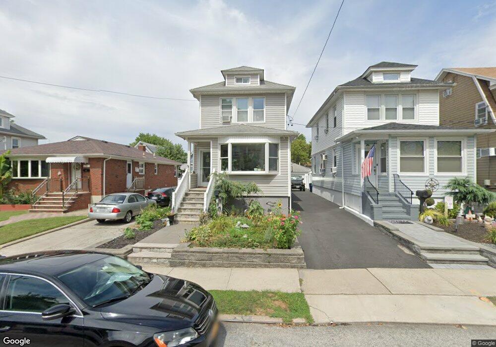
79 Burnside Ave Staten Island, NY 10302
Westerleigh NeighborhoodEstimated Value: $520,824 - $655,000
--
Bed
4
Baths
992
Sq Ft
$615/Sq Ft
Est. Value
About This Home
This home is located at 79 Burnside Ave, Staten Island, NY 10302 and is currently estimated at $610,206, approximately $615 per square foot. 79 Burnside Ave is a home located in Richmond County with nearby schools including P.S. 30 Westerleigh, I.S. 51 Edwin Markham, and Port Richmond High School.
Ownership History
Date
Name
Owned For
Owner Type
Purchase Details
Closed on
Jul 20, 2012
Sold by
Conti Edward and Conti Margaret
Bought by
Conti Lois
Current Estimated Value
Purchase Details
Closed on
May 19, 2010
Sold by
Leonardo James and Petit Jayne
Bought by
Conti Margaret
Create a Home Valuation Report for This Property
The Home Valuation Report is an in-depth analysis detailing your home's value as well as a comparison with similar homes in the area
Home Values in the Area
Average Home Value in this Area
Purchase History
| Date | Buyer | Sale Price | Title Company |
|---|---|---|---|
| Conti Lois | -- | Old Republic National Title | |
| Conti Margaret | -- | Old Republic National Title |
Source: Public Records
Tax History Compared to Growth
Tax History
| Year | Tax Paid | Tax Assessment Tax Assessment Total Assessment is a certain percentage of the fair market value that is determined by local assessors to be the total taxable value of land and additions on the property. | Land | Improvement |
|---|---|---|---|---|
| 2025 | $5,161 | $34,500 | $8,713 | $25,787 |
| 2024 | $5,161 | $32,760 | $8,659 | $24,101 |
| 2023 | $4,923 | $24,240 | $6,969 | $17,271 |
| 2022 | $3,081 | $31,320 | $11,040 | $20,280 |
| 2021 | $4,775 | $33,000 | $11,040 | $21,960 |
| 2020 | $3,562 | $29,760 | $11,040 | $18,720 |
| 2019 | $3,238 | $25,860 | $11,040 | $14,820 |
| 2018 | $4,118 | $20,200 | $9,339 | $10,861 |
| 2017 | $3,885 | $19,059 | $8,969 | $10,090 |
| 2016 | $3,780 | $18,909 | $9,506 | $9,403 |
| 2015 | $3,424 | $18,909 | $11,549 | $7,360 |
| 2014 | $3,424 | $17,844 | $11,857 | $5,987 |
Source: Public Records
Map
Nearby Homes
- 57 Burnside Ave
- 78 Burnside Ave
- 1328 Forest Ave
- 36 Shaw Place
- 60 North Ave
- 159 North Ave
- 200 Llewellyn Place
- 40 North Ave
- 172-174 Llewellyn Place
- 615 Jewett Ave
- 32 Dickie Ave
- 349 College Ave
- 46 Catherine St
- 304 Kingsley Ave
- 325 College Ave
- 99 Llewellyn Place
- 79 Mundy Ave
- 155 Cortlandt St
- 246 Dubois Ave
- 21 Dryden Ct
- 81 Burnside Ave
- 75 Burnside Ave
- 85 Burnside Ave
- 73 Burnside Ave
- 89 Burnside Ave
- 78 Veltman Ave
- 80 Veltman Ave
- 69 Burnside Ave
- 74 Veltman Ave
- 93 Burnside Ave
- 84 Veltman Ave
- 70 Veltman Ave
- 86 Veltman Ave
- 80 Burnside Ave
- 65 Burnside Ave
- 97 Burnside Ave
- 90 Veltman Ave
- 66 Veltman Ave
- 76 Burnside Ave
- 74 Burnside Ave