Estimated Value: $477,421 - $610,000
3
Beds
3
Baths
2,300
Sq Ft
$239/Sq Ft
Est. Value
About This Home
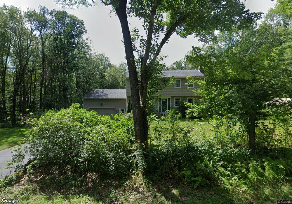
This home is located at 79 N Pembroke Rd, Epsom, NH 03234 and is currently estimated at $549,355, approximately $238 per square foot. 79 N Pembroke Rd is a home located in Merrimack County with nearby schools including Epsom Central School, Tender Years Child Care & Learning Center, and Epsom Better Buddies.
Ownership History
Date
Name
Owned For
Owner Type
Purchase Details
Closed on
Jan 25, 2012
Sold by
Armstrong Richard A
Bought by
Fhlmc
Current Estimated Value
Purchase Details
Closed on
Dec 31, 2002
Sold by
Proulx Dennis A and Proulx Bonnie J
Bought by
Armstrong Richard A and Armstrong Raelynn
Home Financials for this Owner
Home Financials are based on the most recent Mortgage that was taken out on this home.
Original Mortgage
$194,000
Interest Rate
6.02%
Create a Home Valuation Report for This Property
The Home Valuation Report is an in-depth analysis detailing your home's value as well as a comparison with similar homes in the area
Home Values in the Area
Average Home Value in this Area
Purchase History
| Date | Buyer | Sale Price | Title Company |
|---|---|---|---|
| Fhlmc | $207,300 | -- | |
| Fhlmc | $207,300 | -- | |
| Armstrong Richard A | $215,600 | -- | |
| Armstrong Richard A | $215,600 | -- |
Source: Public Records
Mortgage History
| Date | Status | Borrower | Loan Amount |
|---|---|---|---|
| Previous Owner | Armstrong Richard A | $194,000 | |
| Closed | Armstrong Richard A | $0 |
Source: Public Records
Tax History Compared to Growth
Tax History
| Year | Tax Paid | Tax Assessment Tax Assessment Total Assessment is a certain percentage of the fair market value that is determined by local assessors to be the total taxable value of land and additions on the property. | Land | Improvement |
|---|---|---|---|---|
| 2024 | $7,425 | $278,700 | $100,300 | $178,400 |
| 2023 | $6,864 | $278,700 | $100,300 | $178,400 |
| 2022 | $6,670 | $279,800 | $100,300 | $179,500 |
| 2021 | $6,614 | $279,800 | $100,300 | $179,500 |
| 2020 | $6,108 | $279,800 | $100,300 | $179,500 |
| 2019 | $6,323 | $233,400 | $83,600 | $149,800 |
| 2018 | $6,061 | $233,400 | $83,600 | $149,800 |
| 2017 | $2,543 | $233,400 | $83,600 | $149,800 |
| 2016 | $2,543 | $233,400 | $83,600 | $149,800 |
| 2015 | $5,560 | $233,400 | $83,600 | $149,800 |
| 2014 | $4,962 | $222,900 | $71,300 | $151,600 |
| 2013 | $5,031 | $222,900 | $71,300 | $151,600 |
Source: Public Records
Map
Nearby Homes
- 0 Poor Town Rd Unit 4
- 370 River Rd
- 9 Princess Ln
- 11 Presidential Dr
- 43 Catamount Hill Dr
- 8 Bush Ave
- 1 Jefferson Ave
- 5 Catamount Hill Dr
- 41 Monroe Ave
- 425 Grady Ln Unit 28
- 101 4th Range Rd Unit 4
- 441 Blane Cir Unit 12
- 452 Blane Cir Unit 45
- 401 Sixth Range Rd
- 9 Pine Acres Rd
- 348 Brickett Hill Rd Unit 3
- 611 N Pembroke Rd
- 344 Brickett Hill Rd Unit 2
- 344 Brickett Hill Rd
- 340 Brickett Hill Rd
- 85 N Pembroke Rd
- 65 N Pembroke Rd
- 93 N Pembroke Rd
- 59 N Pembroke Rd
- 78 N Pembroke Rd
- 99 N Pembroke Rd
- 51 N Pembroke Rd
- 54 N Pembroke Rd
- 62 N Pembroke Rd
- 43 N Pembroke Rd
- 46 N Pembroke Rd
- 111 N Pembroke Rd
- 29 Lena Ln
- 33 N Pembroke Rd
- 96 N Pembroke Rd
- 112 N Pembroke Rd
- 38 N Pembroke Rd
- 33 Lena Ln
- 119 N Pembroke Rd