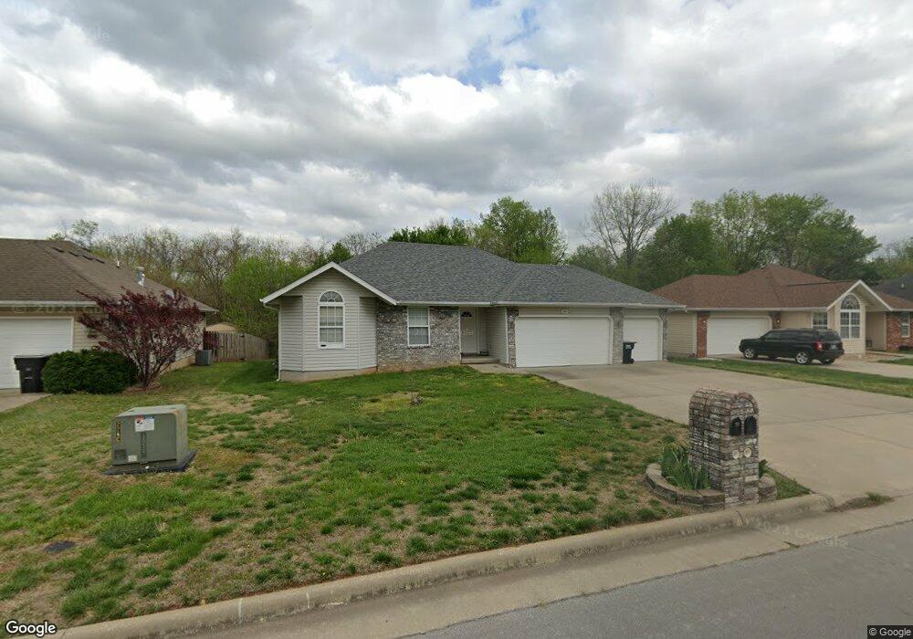
798 S Lester Rd Springfield, MO 65802
Young-Lilly NeighborhoodEstimated Value: $240,000 - $245,096
3
Beds
2
Baths
1,360
Sq Ft
$179/Sq Ft
Est. Value
About This Home
This home is located at 798 S Lester Rd, Springfield, MO 65802 and is currently estimated at $242,774, approximately $178 per square foot. 798 S Lester Rd is a home located in Greene County with nearby schools including Willard Orchard Hills Elementary School and Willard Intermediate-South.
Create a Home Valuation Report for This Property
The Home Valuation Report is an in-depth analysis detailing your home's value as well as a comparison with similar homes in the area
Home Values in the Area
Average Home Value in this Area
Tax History
| Year | Tax Paid | Tax Assessment Tax Assessment Total Assessment is a certain percentage of the fair market value that is determined by local assessors to be the total taxable value of land and additions on the property. | Land | Improvement |
|---|---|---|---|---|
| 2025 | $2,088 | $36,970 | $8,550 | $28,420 |
| 2024 | $1,693 | $30,190 | $3,800 | $26,390 |
| 2023 | $1,685 | $30,190 | $3,800 | $26,390 |
| 2022 | $1,426 | $25,310 | $3,800 | $21,510 |
| 2021 | $1,426 | $25,310 | $3,800 | $21,510 |
| 2020 | $1,194 | $23,010 | $3,800 | $19,210 |
| 2019 | $1,189 | $23,010 | $3,800 | $19,210 |
| 2018 | $1,079 | $20,770 | $3,800 | $16,970 |
| 2017 | $0 | $20,770 | $3,800 | $16,970 |
| 2016 | $1,065 | $20,770 | $3,800 | $16,970 |
| 2015 | $1,057 | $20,770 | $3,800 | $16,970 |
| 2014 | $1,056 | $20,600 | $3,800 | $16,800 |
Source: Public Records
Map
Nearby Homes
- 820 S Quade Rd
- 5163 W Sunstruck St
- 5175 W Sunstruck St
- 5131 W Sunstruck St
- 5439 W Harrison St
- 795 S Natalie Ave
- 5355 Basswood Ct W
- 875 S Natalie Ave
- 5441 Basswood Ct W
- 5021 W Tarkio St
- 5560 W Longleaf Dr
- 5817 W Alexa Ln
- 5145 W Sunstruck St
- 5669 W Sunflower Dr
- 768 S Long Dr
- 413 S Dove Valley Ave
- 4800 W Mount Vernon St
- 1236 S Birch Ave
- 5635 W Mangrove St
- 000 W Independence Dr
- 786 S Lester Rd
- 810 S Lester Rd
- 774 S Lester Rd
- 822 S Lester Rd
- 797 S Lester Rd
- 785 S Lester Rd
- 809 S Lester Rd
- 762 S Lester Rd
- 773 S Lester Rd
- 821 S Lester Rd
- 761 S Lester Rd
- 846 S Lester Rd
- 5333 W Page St
- 796 S Quade Rd
- 784 S Quade Rd
- 808 S Quade Rd
- 749 S Lester Rd
- 5345 W Page St
- 772 S Quade Rd
- 760 S Quade Rd
Your Personal Tour Guide
Ask me questions while you tour the home.