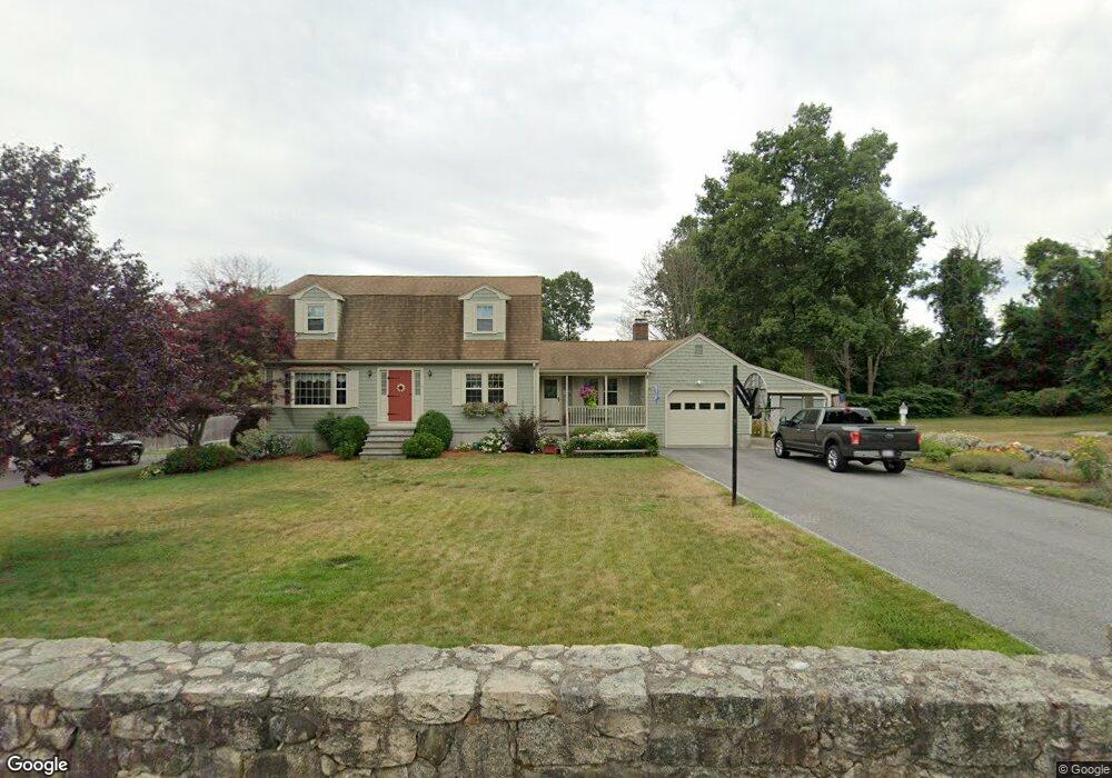
8 Agnes Rd Milford, MA 01757
Estimated Value: $644,000 - $740,000
3
Beds
3
Baths
3,258
Sq Ft
$211/Sq Ft
Est. Value
About This Home
This home is located at 8 Agnes Rd, Milford, MA 01757 and is currently estimated at $687,847, approximately $211 per square foot. 8 Agnes Rd is a home located in Worcester County with nearby schools including Milford High School and Bethany Christian Academy.
Ownership History
Date
Name
Owned For
Owner Type
Purchase Details
Closed on
Aug 10, 2016
Sold by
Peter R & M Filosa Rt
Bought by
Filosa Peter R and Filosa Maryellen
Current Estimated Value
Purchase Details
Closed on
Apr 5, 2010
Sold by
Filosa Peter R and Filosa Maryellen
Bought by
Filosa Tr Peter R and Filosa Maryellen
Purchase Details
Closed on
Mar 16, 1976
Bought by
Filosa Peter R and Filosa Maryellen
Create a Home Valuation Report for This Property
The Home Valuation Report is an in-depth analysis detailing your home's value as well as a comparison with similar homes in the area
Home Values in the Area
Average Home Value in this Area
Purchase History
| Date | Buyer | Sale Price | Title Company |
|---|---|---|---|
| Filosa Peter R | -- | -- | |
| Filosa Tr Peter R | -- | -- | |
| Filosa Peter R | -- | -- |
Source: Public Records
Mortgage History
| Date | Status | Borrower | Loan Amount |
|---|---|---|---|
| Previous Owner | Filosa Peter R | $30,000 | |
| Previous Owner | Filosa Peter R | $41,000 | |
| Previous Owner | Filosa Peter R | $40,000 | |
| Previous Owner | Filosa Peter R | $25,000 |
Source: Public Records
Tax History Compared to Growth
Tax History
| Year | Tax Paid | Tax Assessment Tax Assessment Total Assessment is a certain percentage of the fair market value that is determined by local assessors to be the total taxable value of land and additions on the property. | Land | Improvement |
|---|---|---|---|---|
| 2025 | $7,356 | $574,700 | $199,600 | $375,100 |
| 2024 | $7,282 | $547,900 | $191,700 | $356,200 |
| 2023 | $6,901 | $477,600 | $165,700 | $311,900 |
| 2022 | $6,484 | $421,300 | $151,700 | $269,600 |
| 2021 | $6,160 | $385,500 | $151,700 | $233,800 |
| 2020 | $6,087 | $381,400 | $151,700 | $229,700 |
| 2019 | $5,916 | $357,700 | $151,700 | $206,000 |
| 2018 | $5,857 | $353,700 | $147,700 | $206,000 |
| 2017 | $5,714 | $340,300 | $147,700 | $192,600 |
| 2016 | $5,625 | $327,400 | $147,700 | $179,700 |
| 2015 | $5,495 | $313,100 | $139,700 | $173,400 |
Source: Public Records
Map
Nearby Homes
- 1 Godfrey Ln Unit 1
- 8 Colonial Rd
- 9 Packard Rd
- 104 Purchase St
- 5 Walker Ave
- 39 Emmons St
- 12 Congress Terrace
- 94 Highland St
- 95 High St
- 13 Hemlock Ln
- 4 Kennedy Ln Unit 49
- 92 High St
- 9 Hancock St
- 14 C Country Club Ln
- 7 Shadowbrook Ln Unit 9
- 3 Shadowbrook Ln Unit 3
- 5 Shadowbrook Ln Unit 32
- 10 Shadowbrook Ln Unit 24
- 4 Shadowbrook Ln Unit 31
- 8 Shadowbrook Ln Unit 39