Estimated Value: $633,000 - $685,000
3
Beds
2
Baths
1,948
Sq Ft
$336/Sq Ft
Est. Value
About This Home
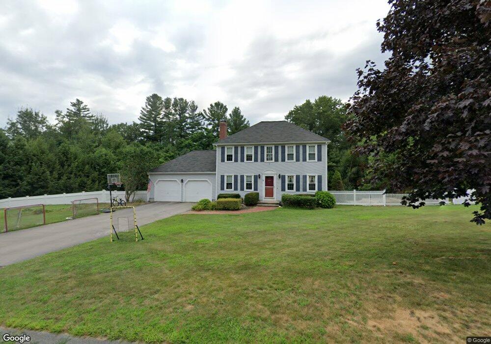
This home is located at 8 Merriam Way, Upton, MA 01568 and is currently estimated at $654,451, approximately $335 per square foot. 8 Merriam Way is a home located in Worcester County with nearby schools including Nipmuc Regional High School, Touchstone Community School, and Silver Spruce Montessori School.
Ownership History
Date
Name
Owned For
Owner Type
Purchase Details
Closed on
Jul 11, 2007
Sold by
Schissel Aimee T and Schissel Mark J
Bought by
Gagin David S and Gagin Leigh M
Current Estimated Value
Home Financials for this Owner
Home Financials are based on the most recent Mortgage that was taken out on this home.
Original Mortgage
$341,600
Outstanding Balance
$209,244
Interest Rate
6.48%
Mortgage Type
Purchase Money Mortgage
Estimated Equity
$445,207
Purchase Details
Closed on
Apr 17, 1998
Sold by
Gomes Gabriel J and Gomes Helene I
Bought by
Hyles Aimee T and Schissel Mark J
Create a Home Valuation Report for This Property
The Home Valuation Report is an in-depth analysis detailing your home's value as well as a comparison with similar homes in the area
Home Values in the Area
Average Home Value in this Area
Purchase History
| Date | Buyer | Sale Price | Title Company |
|---|---|---|---|
| Gagin David S | $427,000 | -- | |
| Hyles Aimee T | $215,000 | -- |
Source: Public Records
Mortgage History
| Date | Status | Borrower | Loan Amount |
|---|---|---|---|
| Open | Gagin David S | $341,600 | |
| Previous Owner | Hyles Aimee T | $249,000 | |
| Previous Owner | Hyles Aimee T | $250,000 | |
| Previous Owner | Hyles Aimee T | $70,000 |
Source: Public Records
Tax History
| Year | Tax Paid | Tax Assessment Tax Assessment Total Assessment is a certain percentage of the fair market value that is determined by local assessors to be the total taxable value of land and additions on the property. | Land | Improvement |
|---|---|---|---|---|
| 2025 | $7,774 | $591,200 | $246,200 | $345,000 |
| 2024 | $7,793 | $569,700 | $239,400 | $330,300 |
| 2023 | $5,778 | $416,600 | $171,000 | $245,600 |
| 2022 | $6,951 | $414,500 | $171,000 | $243,500 |
| 2021 | $7,370 | $444,000 | $208,600 | $235,400 |
| 2020 | $7,398 | $429,600 | $198,300 | $231,300 |
| 2019 | $7,085 | $409,300 | $172,300 | $237,000 |
| 2018 | $7,063 | $409,900 | $179,200 | $230,700 |
| 2017 | $7,115 | $391,800 | $175,800 | $216,000 |
| 2016 | $6,815 | $367,200 | $140,300 | $226,900 |
| 2015 | $6,163 | $363,600 | $140,300 | $223,300 |
| 2014 | $5,968 | $352,100 | $133,200 | $218,900 |
Source: Public Records
Map
Nearby Homes
- 10 Mechanic St
- 135 Main St
- 74 Warren St
- Lot 108 W Main St
- 36 Knowlton Cir Unit 1
- 51 Knowlton Cir Unit 51
- 4 Hazeltine Rd
- 1 Knowlton Cir Unit 1
- 72 Main St
- 13 Plain St
- 6 Fieldstone Dr Unit 6
- 7 Fieldstone Dr Unit 7
- 100 Buttercup Ln Unit 100
- 8 Maple St
- 130 High St
- 49 Grove St
- 31 Elm St
- 18 Boot Shop Rd Unit 40
- 15 Shoemaker Ln Unit 7
- 6 Chickadee Way Unit 23
Your Personal Tour Guide
Ask me questions while you tour the home.