
Seller's Agent in 2025
Patricia McCormick
J. Barrett & Company
(978) 290-0538
3 in this area
37 Total Sales

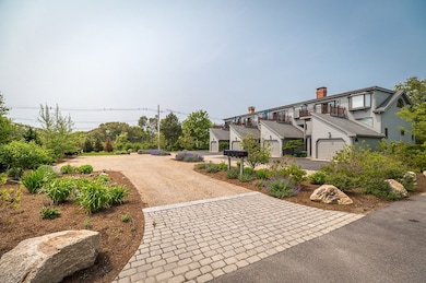


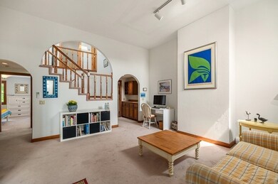
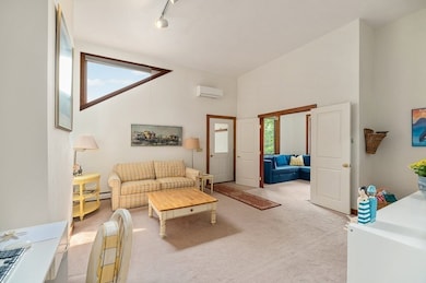

Enjoy stunning views of Gloucester’s iconic Back Shore and the Twin Lights on Thacher Island from this ideally located move in ready 2-bedroom, 2-bath condo at 8 Moorland Road. Nestled beside Bass Rocks Golf Club and just minutes to Good Harbor Beach, this spacious home features vaulted ceilings, abundant natural light and a flexible open-concept layout designed to highlight coastal views. A private deck overlooking perennial gardens and water views provides the perfect spot for coffee at sunrise or coastal breezes at sunset. With a den/office, in-unit laundry and an attached garage, the unit combines comfort with convenience. In addition to a flexible floor plan and an unbeatable location, this home provides an excellent opportunity to make it your own. Set in one of Gloucester’s most beloved locations, this is a rare chance to enjoy Cape Ann’s stunning beaches, vibrant arts scene, working harbor, and deep maritime history.
| Date | Type | Sale Price | Title Company |
|---|---|---|---|
| Deed | $850,000 | -- | |
| Deed | $219,900 | -- | |
| Deed | $219,900 | -- | |
| Deed | $200,000 | -- | |
| Deed | $200,000 | -- | |
| Deed | $70,000 | -- |
| Date | Status | Loan Amount | Loan Type |
|---|---|---|---|
| Closed | $0 | No Value Available |
| Date | Event | Price | List to Sale | Price per Sq Ft |
|---|---|---|---|---|
| 10/01/2025 10/01/25 | Sold | $850,000 | 0.0% | $487 / Sq Ft |
| 06/27/2025 06/27/25 | Pending | -- | -- | -- |
| 06/26/2025 06/26/25 | Price Changed | $850,000 | -5.6% | $487 / Sq Ft |
| 06/12/2025 06/12/25 | For Sale | $900,000 | -- | $516 / Sq Ft |
| Year | Tax Paid | Tax Assessment Tax Assessment Total Assessment is a certain percentage of the fair market value that is determined by local assessors to be the total taxable value of land and additions on the property. | Land | Improvement |
|---|---|---|---|---|
| 2025 | $8,361 | $860,200 | $0 | $860,200 |
| 2024 | $7,847 | $806,500 | $0 | $806,500 |
| 2023 | $6,709 | $633,500 | $0 | $633,500 |
| 2022 | $6,739 | $574,500 | $0 | $574,500 |
| 2021 | $6,728 | $540,800 | $0 | $540,800 |
| 2020 | $6,747 | $547,200 | $0 | $547,200 |
| 2019 | $6,756 | $532,400 | $0 | $532,400 |
| 2018 | $6,643 | $513,800 | $0 | $513,800 |
| 2017 | $6,640 | $503,400 | $0 | $503,400 |
| 2016 | $6,314 | $463,900 | $0 | $463,900 |
| 2015 | $6,269 | $459,300 | $0 | $459,300 |
Seller's Agent in 2025
Patricia McCormick
J. Barrett & Company
(978) 290-0538
3 in this area
37 Total Sales
Buyer's Agent in 2025
John Veneziano
RE/MAX
(617) 840-5499
1 in this area
93 Total Sales
Source: MLS Property Information Network (MLS PIN)
MLS Number: 73390403
APN: GLOU-000071-000017-000001
Disclaimer: Certain information contained herein is derived from information provided by parties other than Homes.com. All information provided is deemed reliable, but is not guaranteed to be accurate and should be independently verified.
![]() The property listing data and information, or the Images, set forth herein were provided to MLS Property Information Network, Inc. from third party sources, including sellers, lessors and public records, and were compiled by MLS Property Information Network, Inc. The property listing data and information, and the Images, are for the personal, non-commercial use of consumers having a good faith interest in purchasing or leasing listed properties of the type displayed to them and may not be used for any purpose other than to identify prospective properties which such consumers may have a good faith interest in purchasing or leasing. MLS Property Information Network, Inc. and its subscribers disclaim any and all representations and warranties as to the accuracy of the property listing data and information, or as to the accuracy of any of the Images, set forth herein.
The property listing data and information, or the Images, set forth herein were provided to MLS Property Information Network, Inc. from third party sources, including sellers, lessors and public records, and were compiled by MLS Property Information Network, Inc. The property listing data and information, and the Images, are for the personal, non-commercial use of consumers having a good faith interest in purchasing or leasing listed properties of the type displayed to them and may not be used for any purpose other than to identify prospective properties which such consumers may have a good faith interest in purchasing or leasing. MLS Property Information Network, Inc. and its subscribers disclaim any and all representations and warranties as to the accuracy of the property listing data and information, or as to the accuracy of any of the Images, set forth herein.