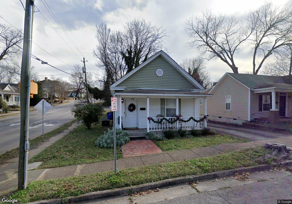
8 N Swain St Raleigh, NC 27601
Oakwood NeighborhoodEstimated Value: $326,075 - $511,000
2
Beds
2
Baths
906
Sq Ft
$431/Sq Ft
Est. Value
About This Home
This home is located at 8 N Swain St, Raleigh, NC 27601 and is currently estimated at $390,269, approximately $430 per square foot. 8 N Swain St is a home located in Wake County with nearby schools including Powell Elementary, Ligon Magnet Middle School, and Broughton Magnet High School.
Ownership History
Date
Name
Owned For
Owner Type
Purchase Details
Closed on
Aug 13, 2025
Sold by
Pearl Jones Holland Revocable Trust and Spong Angela R
Bought by
Fenner Cheryl H and Holland Michael V
Current Estimated Value
Purchase Details
Closed on
Apr 17, 2006
Sold by
Holland Pearl Jones
Bought by
Holland Pearl Jones
Purchase Details
Closed on
Oct 20, 1999
Sold by
Holland Charles V and Holland Pearl J
Bought by
Holland Charles
Purchase Details
Closed on
Jan 1, 1978
Bought by
Holland Pearl Jones
Create a Home Valuation Report for This Property
The Home Valuation Report is an in-depth analysis detailing your home's value as well as a comparison with similar homes in the area
Home Values in the Area
Average Home Value in this Area
Purchase History
| Date | Buyer | Sale Price | Title Company |
|---|---|---|---|
| Fenner Cheryl H | -- | None Listed On Document | |
| Holland Pearl Jones | -- | None Available | |
| Holland Charles | -- | -- | |
| Holland Pearl Jones | $5,000 | -- |
Source: Public Records
Tax History Compared to Growth
Tax History
| Year | Tax Paid | Tax Assessment Tax Assessment Total Assessment is a certain percentage of the fair market value that is determined by local assessors to be the total taxable value of land and additions on the property. | Land | Improvement |
|---|---|---|---|---|
| 2025 | $2,445 | $278,008 | $156,840 | $121,168 |
| 2024 | $2,435 | $278,008 | $156,840 | $121,168 |
| 2023 | $1,927 | $174,962 | $94,104 | $80,858 |
| 2022 | $1,791 | $174,962 | $94,104 | $80,858 |
| 2021 | $1,722 | $174,962 | $94,104 | $80,858 |
| 2020 | $1,691 | $174,962 | $94,104 | $80,858 |
| 2019 | $1,109 | $94,007 | $34,034 | $59,973 |
| 2018 | $1,047 | $94,007 | $34,034 | $59,973 |
| 2017 | $998 | $94,007 | $34,034 | $59,973 |
| 2016 | $978 | $94,007 | $34,034 | $59,973 |
| 2015 | -- | $60,951 | $15,684 | $45,267 |
| 2014 | $618 | $60,951 | $15,684 | $45,267 |
Source: Public Records
Map
Nearby Homes
- 536 E Jones St
- 537 New Bern Ave Unit 101
- 521 E Edenton St
- 712 E Edenton St Unit 102
- 801 New Bern Ave Unit 102
- 2 Seawell Ave Unit 101
- 225 Elm St
- 304 Linden Ave
- 810 E Edenton St
- 318 Cooke St
- 820 New Bern Ave Unit 820-822-824-826
- 216 N Bloodworth St
- 406 E Lane St
- 105 Heck St
- 203 Heck St
- 207 Heck St
- 105-111 Heck St
- 138 S East St
- 706 E Hargett St
- 419 Watauga St
- 6 N Swain St
- 35 N Swain St
- 7 N Swain St
- 5 N Swain St
- 413 E Edenton St
- 605 E Edenton St
- 607 E Edenton St
- 556 E Edenton St
- 609 E Edenton St
- 555 E Edenton St
- 561 E Edenton St
- 563 E Edenton St
- 567 New Bern Ave
- 519 E Edenton St
- 613 E Edenton St
- 554 E Edenton St
- 559 E Edenton St
- 702 E Edenton St
- 110 N Swain St
- 561 New Bern Ave