8 Neff Hill Rd Tolland, CT 06084
Estimated payment $1,066/month
Highlights
- 3.72 Acre Lot
- Tolland High School Rated A-
- Partially Wooded Lot
About This Lot
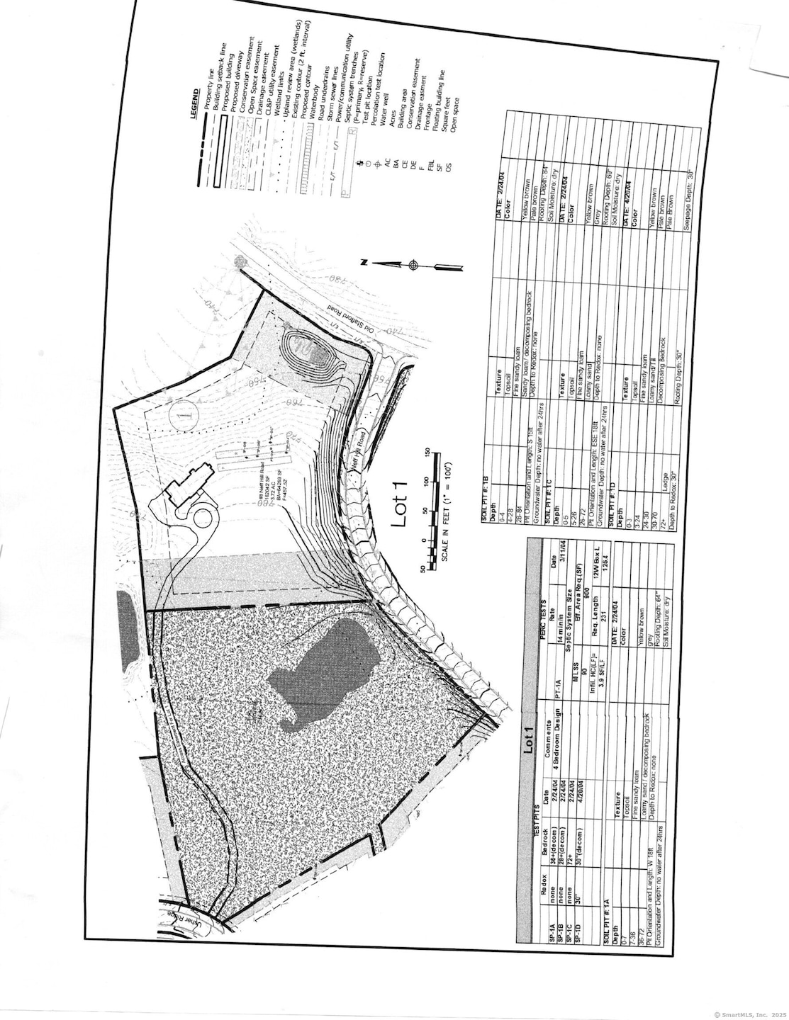
Lot #1 is the most secluded and largest lot still available...Lot is cleared...Owl Ridge (formerly Carriage Crossing), a sub-division of in a forested area...166 acres with 45 homesites...lot sizes range from an acre plus to 6 acres plus...Located 8 to 10 miles to I-84 and approximately 30 minutes to Hartford...UConn is a mere 10 to 15 minutes away...Utilities are available and the lot is shovel ready and needs only your builder to get started.
Property Details
Property Type
- Land
Est. Annual Taxes
- $2,635
Lot Details
- 3.72 Acre Lot
- Partially Wooded Lot
Schools
- Birch Grove Elementary School
- Tolland Middle School
- Tolland High School
Utilities
- Well Required
- Phone Available
- Cable TV Available
Community Details
- Owl Ridge Subdivision
Listing and Financial Details
- Assessor Parcel Number 2488236
Map
Home Values in the Area
Average Home Value in this Area
Tax History
| Year | Tax Paid | Tax Assessment Tax Assessment Total Assessment is a certain percentage of the fair market value that is determined by local assessors to be the total taxable value of land and additions on the property. | Land | Improvement |
|---|---|---|---|---|
| 2025 | $2,635 | $96,900 | $96,900 | $0 |
| 2024 | $3,509 | $92,900 | $92,900 | $0 |
| 2023 | $3,468 | $92,900 | $92,900 | $0 |
| 2022 | $3,398 | $92,900 | $92,900 | $0 |
| 2021 | $3,448 | $92,900 | $92,900 | $0 |
| 2020 | $3,349 | $92,900 | $92,900 | $0 |
| 2019 | $3,443 | $95,500 | $95,500 | $0 |
| 2018 | $3,343 | $95,500 | $95,500 | $0 |
| 2017 | $3,265 | $95,500 | $95,500 | $0 |
| 2016 | $3,265 | $95,500 | $95,500 | $0 |
| 2015 | $3,186 | $95,500 | $95,500 | $0 |
| 2014 | $3,270 | $105,300 | $105,300 | $0 |
Property History
| Date | Event | Price | List to Sale | Price per Sq Ft |
|---|---|---|---|---|
| 07/03/2025 07/03/25 | Price Changed | $160,470 | +0.8% | -- |
| 03/31/2025 03/31/25 | Price Changed | $159,150 | +4.9% | -- |
| 03/28/2025 03/28/25 | For Sale | $151,760 | -- | -- |
Source: SmartMLS
MLS Number: 24084036
APN: TOLL-000004-B000000-000008-000003
Disclaimer: Certain information contained herein is derived from information provided by parties other than Homes.com. All information provided is deemed reliable, but is not guaranteed to be accurate and should be independently verified.
![]() IDX information is provided exclusively for personal, non-commercial use, and may not be used for any purpose other than to identify prospective properties consumers may be interested in purchasing. Information is deemed reliable but not guaranteed.
IDX information is provided exclusively for personal, non-commercial use, and may not be used for any purpose other than to identify prospective properties consumers may be interested in purchasing. Information is deemed reliable but not guaranteed.
- 745 Old Stafford Rd
- 15 Usher Ridge
- 68 Usher Ridge
- 36 Usher Ridge
- 110 Neff Hill Rd
- 130 Neff Hill Rd
- 105 Neff Hill Rd
- 137 Neff Hill Rd
- 100 Neff Hill Rd
- 77 Neff Hill Rd
- 84 Neff Hill Rd
- 71 Neff Hill Rd
- 644 Buff Cap Rd
- 487 Buff Cap Rd
- 42 Ladd Rd
- 100 Wildwood Rd
- 66 Deerwood Rd
- 68 Cook Rd
- 476 Old Stafford Rd
- 127 Sandy Beach Rd
- 18 Clifford Ave
- 86 Buff Cap Rd
- 20 Park St Unit B
- 38-40 Converse St Unit C
- 20 Willington Ave Unit 3
- 132 Furnace Ave
- 108 Monson Rd Unit A
- 9-16 Village St
- 609 Merrow Rd
- 51 Meadow Brook Rd
- 168 E Main St Unit 1
- 7 Fern St Unit 7
- 49 Hydeville Rd
- 43 Burt Latham Rd
- 86 Grove St Unit 3
- 28 Prospect St
- 8 Gaynor Place Unit 1
- 200 West Rd
- 35 Arbor Way
- 213 Baxter Rd Unit B
