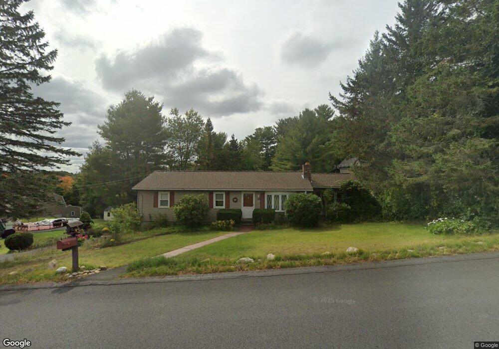
80 Leo Dr Gardner, MA 01440
Estimated Value: $391,000 - $475,000
3
Beds
2
Baths
1,294
Sq Ft
$336/Sq Ft
Est. Value
About This Home
This home is located at 80 Leo Dr, Gardner, MA 01440 and is currently estimated at $435,265, approximately $336 per square foot. 80 Leo Dr is a home located in Worcester County with nearby schools including Gardner High School and Holy Family Academy.
Ownership History
Date
Name
Owned For
Owner Type
Purchase Details
Closed on
Jan 26, 2001
Sold by
Stamps Sandra J and Turgeon Sandra J
Bought by
Keefer Brian
Current Estimated Value
Home Financials for this Owner
Home Financials are based on the most recent Mortgage that was taken out on this home.
Original Mortgage
$112,000
Outstanding Balance
$41,394
Interest Rate
7.39%
Mortgage Type
Purchase Money Mortgage
Estimated Equity
$393,871
Purchase Details
Closed on
Jan 27, 2000
Sold by
Taupier Robert V and Taupier Jacqueline I
Bought by
Stamps Sandra J
Home Financials for this Owner
Home Financials are based on the most recent Mortgage that was taken out on this home.
Original Mortgage
$113,200
Interest Rate
7.83%
Mortgage Type
Purchase Money Mortgage
Create a Home Valuation Report for This Property
The Home Valuation Report is an in-depth analysis detailing your home's value as well as a comparison with similar homes in the area
Home Values in the Area
Average Home Value in this Area
Purchase History
| Date | Buyer | Sale Price | Title Company |
|---|---|---|---|
| Keefer Brian | $147,000 | -- | |
| Stamps Sandra J | $141,500 | -- |
Source: Public Records
Mortgage History
| Date | Status | Borrower | Loan Amount |
|---|---|---|---|
| Open | Stamps Sandra J | $112,000 | |
| Previous Owner | Stamps Sandra J | $113,200 | |
| Previous Owner | Stamps Sandra J | $80,000 | |
| Previous Owner | Stamps Sandra J | $76,900 |
Source: Public Records
Tax History
| Year | Tax Paid | Tax Assessment Tax Assessment Total Assessment is a certain percentage of the fair market value that is determined by local assessors to be the total taxable value of land and additions on the property. | Land | Improvement |
|---|---|---|---|---|
| 2025 | $52 | $358,900 | $82,100 | $276,800 |
| 2024 | $5,076 | $338,600 | $74,600 | $264,000 |
| 2023 | $4,726 | $293,000 | $73,500 | $219,500 |
| 2022 | $4,363 | $234,700 | $55,700 | $179,000 |
| 2021 | $4,248 | $212,000 | $48,400 | $163,600 |
| 2020 | $4,062 | $205,800 | $48,400 | $157,400 |
| 2019 | $3,835 | $190,400 | $48,400 | $142,000 |
| 2018 | $3,640 | $179,600 | $48,400 | $131,200 |
| 2017 | $3,488 | $170,300 | $48,400 | $121,900 |
| 2016 | $3,328 | $162,600 | $48,400 | $114,200 |
| 2015 | $3,157 | $158,000 | $48,400 | $109,600 |
| 2014 | $3,068 | $162,600 | $56,100 | $106,500 |
Source: Public Records
Map
Nearby Homes
Your Personal Tour Guide
Ask me questions while you tour the home.