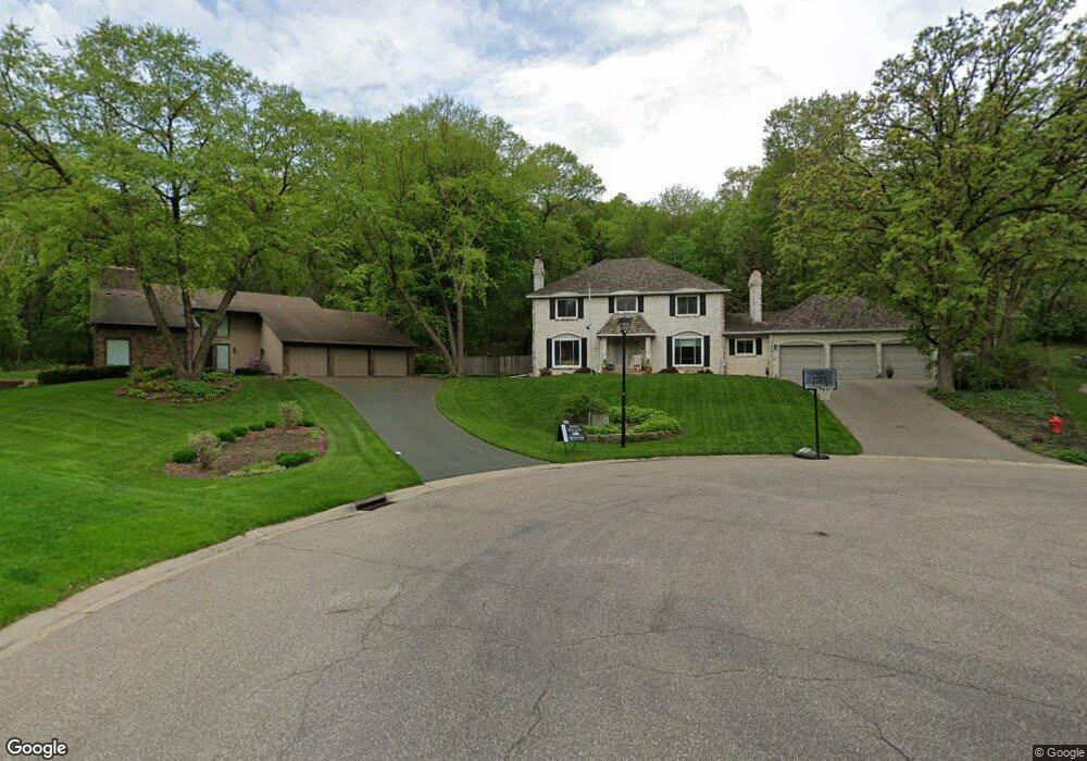
8025 132nd Ct Saint Paul, MN 55124
Alimagnet NeighborhoodEstimated Value: $552,000 - $609,000
4
Beds
4
Baths
4,008
Sq Ft
$144/Sq Ft
Est. Value
About This Home
This home is located at 8025 132nd Ct, Saint Paul, MN 55124 and is currently estimated at $577,401, approximately $144 per square foot. 8025 132nd Ct is a home located in Dakota County with nearby schools including Echo Park Elementary School of Leadership, Engineering & Technology, Falcon Ridge Middle School, and Apple Valley Senior High School.
Ownership History
Date
Name
Owned For
Owner Type
Purchase Details
Closed on
Sep 29, 2015
Sold by
Swanke Margaret J and Swanke James A
Bought by
Koob David J and Koob Angela T
Current Estimated Value
Home Financials for this Owner
Home Financials are based on the most recent Mortgage that was taken out on this home.
Original Mortgage
$327,600
Outstanding Balance
$261,531
Interest Rate
4.4%
Mortgage Type
FHA
Estimated Equity
$315,870
Create a Home Valuation Report for This Property
The Home Valuation Report is an in-depth analysis detailing your home's value as well as a comparison with similar homes in the area
Home Values in the Area
Average Home Value in this Area
Purchase History
| Date | Buyer | Sale Price | Title Company |
|---|---|---|---|
| Koob David J | $346,251 | Midland Title |
Source: Public Records
Mortgage History
| Date | Status | Borrower | Loan Amount |
|---|---|---|---|
| Open | Koob David J | $327,600 |
Source: Public Records
Tax History Compared to Growth
Tax History
| Year | Tax Paid | Tax Assessment Tax Assessment Total Assessment is a certain percentage of the fair market value that is determined by local assessors to be the total taxable value of land and additions on the property. | Land | Improvement |
|---|---|---|---|---|
| 2024 | $5,364 | $477,700 | $162,500 | $315,200 |
| 2023 | $5,364 | $472,700 | $162,800 | $309,900 |
| 2022 | $4,678 | $455,600 | $162,300 | $293,300 |
| 2021 | $4,684 | $402,400 | $141,200 | $261,200 |
| 2020 | $4,794 | $394,600 | $134,400 | $260,200 |
| 2019 | $4,092 | $391,800 | $128,000 | $263,800 |
| 2018 | $4,326 | $351,900 | $121,900 | $230,000 |
| 2017 | $4,403 | $355,100 | $116,100 | $239,000 |
| 2016 | $4,435 | $343,400 | $110,600 | $232,800 |
| 2015 | $4,455 | $335,431 | $106,349 | $229,082 |
| 2014 | -- | $339,464 | $102,645 | $236,819 |
| 2013 | -- | $327,910 | $94,556 | $233,354 |
Source: Public Records
Map
Nearby Homes
- 13420 Gull Ct
- 13101 Heritage Way
- 110 Pony Ln E
- 13345 Huntington Cir
- 12867 Pennock Ave
- 13306 Huntington Cir
- 13199 Gemstone Ct
- 13413 Georgia Cir
- 13715 Grafton Ct
- 7577 138th St W
- 13761 Hollybrook Cir
- 13751 Hollybrook Cir
- 108 Hidden Meadow Rd
- 13731 Hollybrook Cir
- 13727 Hollybrook Cir
- The Sophia Plan at Eagle Pointe - Townhomes
- The Amelia Plan at Eagle Pointe - Townhomes
- The Magnolia Plan at Eagle Pointe - Townhomes
- The Nolan Plan at Eagle Pointe - Townhomes
- 13868 Glendale Ct
- 8015 132nd Ct
- 8020 132nd Ct
- 8005 132nd Ct
- 8000 132nd Ct
- 13147 Hannover Ct
- 8010 132nd Ct
- 7995 132nd Ct
- 13153 Hannover Ct
- 8464 133rd Street Ct
- 8460 133rd Street Ct
- 7990 132nd Ct
- 7985 132nd Ct
- 13141 Hannover Ct
- 13135 Hannover Ct
- 8015 133rd St W
- 8468 133rd Street Ct
- 13188 Hannover Ave
- 8035 133rd St W
- 13154 Hannover Ave
- 8456 133rd Street Ct