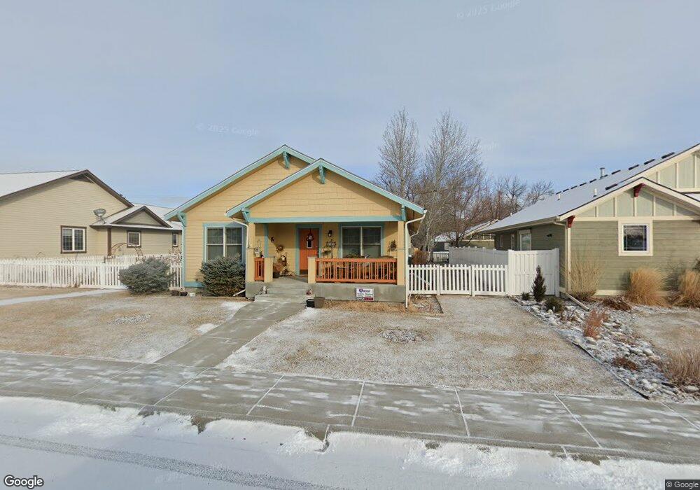
805 Avenue F Billings, MT 59102
Highlands NeighborhoodEstimated Value: $409,000 - $449,000
4
Beds
3
Baths
1,488
Sq Ft
$284/Sq Ft
Est. Value
About This Home
This home is located at 805 Avenue F, Billings, MT 59102 and is currently estimated at $422,732, approximately $284 per square foot. 805 Avenue F is a home located in Yellowstone County with nearby schools including Highland Elementary School, Lewis & Clark Junior High School, and Billings Senior High School.
Ownership History
Date
Name
Owned For
Owner Type
Purchase Details
Closed on
Sep 13, 2016
Sold by
Dapples Birdeena C
Bought by
Crandall Robert S
Current Estimated Value
Home Financials for this Owner
Home Financials are based on the most recent Mortgage that was taken out on this home.
Original Mortgage
$220,000
Outstanding Balance
$101,723
Interest Rate
3.43%
Mortgage Type
New Conventional
Estimated Equity
$321,009
Purchase Details
Closed on
Sep 14, 2006
Sold by
Azalea Company
Bought by
Crandall Robert S and Dapples Birdeena C
Purchase Details
Closed on
May 16, 2005
Sold by
Azalea Company
Bought by
Dapples Birdeena C and Crandall Robert S
Home Financials for this Owner
Home Financials are based on the most recent Mortgage that was taken out on this home.
Original Mortgage
$98,000
Interest Rate
5.87%
Mortgage Type
New Conventional
Create a Home Valuation Report for This Property
The Home Valuation Report is an in-depth analysis detailing your home's value as well as a comparison with similar homes in the area
Home Values in the Area
Average Home Value in this Area
Purchase History
| Date | Buyer | Sale Price | Title Company |
|---|---|---|---|
| Crandall Robert S | -- | Chicago Title | |
| Crandall Robert S | -- | None Available | |
| Dapples Birdeena C | -- | St |
Source: Public Records
Mortgage History
| Date | Status | Borrower | Loan Amount |
|---|---|---|---|
| Open | Crandall Robert S | $220,000 | |
| Previous Owner | Dapples Birdeena C | $98,000 |
Source: Public Records
Tax History Compared to Growth
Tax History
| Year | Tax Paid | Tax Assessment Tax Assessment Total Assessment is a certain percentage of the fair market value that is determined by local assessors to be the total taxable value of land and additions on the property. | Land | Improvement |
|---|---|---|---|---|
| 2025 | $259 | $505,000 | $53,183 | $451,817 |
| 2024 | $259 | $407,300 | $48,238 | $359,062 |
| 2023 | $362 | $407,300 | $48,238 | $359,062 |
| 2022 | $340 | $318,400 | $0 | $0 |
| 2021 | $391 | $318,400 | $0 | $0 |
| 2020 | $341 | $294,100 | $0 | $0 |
| 2019 | $337 | $294,100 | $0 | $0 |
| 2018 | $327 | $276,100 | $0 | $0 |
| 2017 | $317 | $276,100 | $0 | $0 |
| 2016 | $296 | $280,400 | $0 | $0 |
| 2015 | $290 | $280,400 | $0 | $0 |
| 2014 | $280 | $122,006 | $0 | $0 |
Source: Public Records
Map
Nearby Homes
- 813 Avenue F
- 803 Parkhill Dr
- 921 Avenue F
- 743 Avenue C
- 728 Avenue C
- 1506 9th St W
- 644 Avenue B
- 2105 11th St W
- 509 Avenue E
- 1113 Avenue D
- 506 O Malley Dr
- 1010 Poly Dr
- 1217 Avenue F
- 1116 8th St W
- 1212 O Malley Dr
- 620 Highland Park Dr
- 501 Alderson Ave
- 1240 Avenue D Unit 7
- 2328 Pine St
- 1028 Princeton Ave