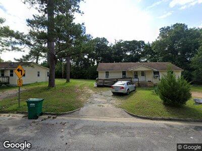
806 Rood St Albany, GA 31705
Dixie Heights NeighborhoodEstimated Value: $37,934 - $92,000
4
Beds
2
Baths
1,500
Sq Ft
$46/Sq Ft
Est. Value
About This Home
This home is located at 806 Rood St, Albany, GA 31705 and is currently estimated at $68,734, approximately $45 per square foot. 806 Rood St is a home located in Dougherty County with nearby schools including Morningside Elementary School, Southside Middle School, and Monroe High School.
Ownership History
Date
Name
Owned For
Owner Type
Purchase Details
Closed on
Aug 6, 2009
Sold by
Mcmillan Harold N and Mcmillan N H
Bought by
A & R Investments Llc
Current Estimated Value
Purchase Details
Closed on
Oct 11, 1954
Bought by
Mcmillian H N
Create a Home Valuation Report for This Property
The Home Valuation Report is an in-depth analysis detailing your home's value as well as a comparison with similar homes in the area
Home Values in the Area
Average Home Value in this Area
Purchase History
| Date | Buyer | Sale Price | Title Company |
|---|---|---|---|
| A & R Investments Llc | -- | -- | |
| A & R Investments Llc | $18,000 | -- | |
| Mcmillian H N | -- | -- |
Source: Public Records
Mortgage History
| Date | Status | Borrower | Loan Amount |
|---|---|---|---|
| Closed | A & R Investments Llc | $59,500 |
Source: Public Records
Tax History Compared to Growth
Tax History
| Year | Tax Paid | Tax Assessment Tax Assessment Total Assessment is a certain percentage of the fair market value that is determined by local assessors to be the total taxable value of land and additions on the property. | Land | Improvement |
|---|---|---|---|---|
| 2024 | $895 | $18,760 | $4,760 | $14,000 |
| 2023 | $874 | $18,760 | $4,760 | $14,000 |
| 2022 | $877 | $18,760 | $4,760 | $14,000 |
| 2021 | $813 | $18,760 | $4,760 | $14,000 |
| 2020 | $815 | $18,760 | $4,760 | $14,000 |
| 2019 | $818 | $18,760 | $4,760 | $14,000 |
| 2018 | $822 | $18,760 | $4,760 | $14,000 |
| 2017 | $766 | $18,760 | $4,760 | $14,000 |
| 2016 | $766 | $18,760 | $4,760 | $14,000 |
| 2015 | $768 | $18,760 | $4,760 | $14,000 |
| 2014 | $678 | $16,760 | $2,760 | $14,000 |
Source: Public Records
Map
Nearby Homes
- 502 Mitchell Ave
- 913 Rood St
- 401 Mitchell Ave
- 1009 Crawford Dr
- 916 Crawford Dr
- 911 Mercedes St
- 1102 Van Deman St
- 1110 Wingate Ave
- 113 Morningside Dr
- 111 Morningside Dr
- 1401 E Waddell Ave
- 1400 E Lincoln Ave
- 804 Cason St
- 811 S Maple St
- 1411 E Gordon Ave
- 211 Collins St
- 608 Cason St
- 210 S Carroll St
- 1219 Bonnyview Ave
- 318 Vick St
- 806 Rood St
- 810 Rood St
- 839 Frotscher St
- 837 Frotscher St
- 805 Rood St
- 601 Mitchell Ave
- 841 Frotscher St
- 831 Frotscher St
- 505 Mitchell Ave
- 803 Rood St
- 801 Rood St
- 503 Mitchell Ave
- 800 Rood St
- 840 Frotscher St
- 508 Mitchell Ave
- 842 Frotscher St
- 904 Rood St
- 604 Mitchell Ave
- 834 Frotscher St
- 701 Mitchell Ave