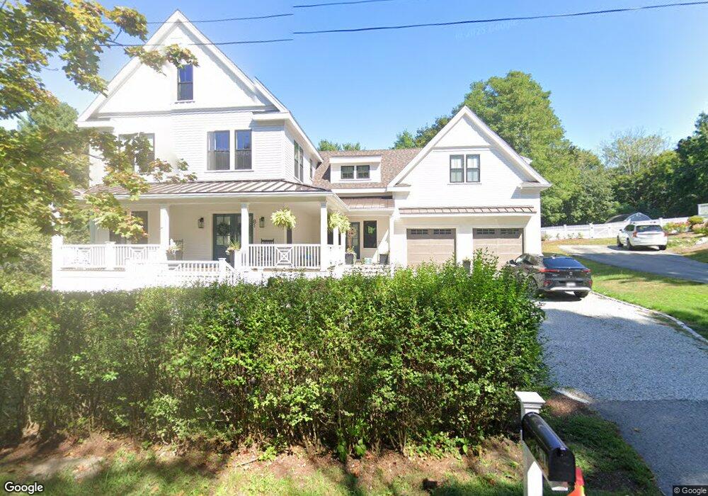
81 Doane St Cohasset, MA 02025
Estimated Value: $1,310,000 - $1,882,664
4
Beds
4
Baths
3,756
Sq Ft
$453/Sq Ft
Est. Value
About This Home
This home is located at 81 Doane St, Cohasset, MA 02025 and is currently estimated at $1,702,416, approximately $453 per square foot. 81 Doane St is a home located in Norfolk County with nearby schools including Joseph Osgood School, Deer Hill School, and Cohasset Middle School.
Ownership History
Date
Name
Owned For
Owner Type
Purchase Details
Closed on
Jul 13, 2021
Sold by
81 Doane Llc
Bought by
Crossen William and Crossen Sarah
Current Estimated Value
Purchase Details
Closed on
Aug 4, 2016
Sold by
81 Doane Street Rt and Trunnell
Bought by
81 Doane Llc
Purchase Details
Closed on
Jan 7, 2011
Sold by
Rautiala Ruth E
Bought by
81 Doane Street Rt and Rautiala
Create a Home Valuation Report for This Property
The Home Valuation Report is an in-depth analysis detailing your home's value as well as a comparison with similar homes in the area
Home Values in the Area
Average Home Value in this Area
Purchase History
| Date | Buyer | Sale Price | Title Company |
|---|---|---|---|
| Crossen William | $120,000 | None Available | |
| Crossen William | $120,000 | None Available | |
| 81 Doane Llc | $330,000 | -- | |
| 81 Doane Llc | $330,000 | -- | |
| 81 Doane Street Rt | -- | -- | |
| 81 Doane Street Rt | -- | -- | |
| 81 Doane Street Rt | -- | -- | |
| 81 Doane Street Rt | -- | -- |
Source: Public Records
Mortgage History
| Date | Status | Borrower | Loan Amount |
|---|---|---|---|
| Previous Owner | 81 Doane Street Rt | $14,300 | |
| Previous Owner | 81 Doane Street Rt | $17,000 | |
| Previous Owner | 81 Doane Street Rt | $10,000 |
Source: Public Records
Tax History
| Year | Tax Paid | Tax Assessment Tax Assessment Total Assessment is a certain percentage of the fair market value that is determined by local assessors to be the total taxable value of land and additions on the property. | Land | Improvement |
|---|---|---|---|---|
| 2025 | $16,440 | $1,419,700 | $456,500 | $963,200 |
| 2024 | $13,776 | $1,132,000 | $380,100 | $751,900 |
| 2023 | $4,655 | $394,500 | $365,700 | $28,800 |
| 2022 | $5,799 | $461,700 | $243,600 | $218,100 |
| 2021 | $5,743 | $440,400 | $243,600 | $196,800 |
| 2020 | $5,712 | $440,400 | $243,600 | $196,800 |
| 2019 | $5,667 | $439,300 | $243,600 | $195,700 |
| 2018 | $5,619 | $439,300 | $243,600 | $195,700 |
| 2017 | $5,342 | $409,000 | $232,000 | $177,000 |
| 2016 | $4,775 | $370,700 | $193,700 | $177,000 |
| 2015 | $4,712 | $370,700 | $193,700 | $177,000 |
| 2014 | $4,649 | $370,700 | $193,700 | $177,000 |
Source: Public Records
Map
Nearby Homes
- 34 Flintlock Ridge Rd
- 27 Ox Pasture Ln
- 165 R Summer St
- 0 Bates Ln (Lot E Kevin's Way) Unit 73419598
- 453 Clapp Rd
- 449 Clapp Rd
- 451 Clapp Rd
- 453 - 455 Clapp Rd
- 45 Hemlock Way
- 342 Summer St
- 71 Ledgewood Dr
- 67 Mount Hope St
- 46 Pond St
- 31 Chittenden Ln Unit 31
- 101 Pond St
- 817 Country Way
- 11 Forest Ln
- 9 Forest Ln Unit 9
- 40 Pond St
- 137 Fairoaks Ln
Your Personal Tour Guide
Ask me questions while you tour the home.