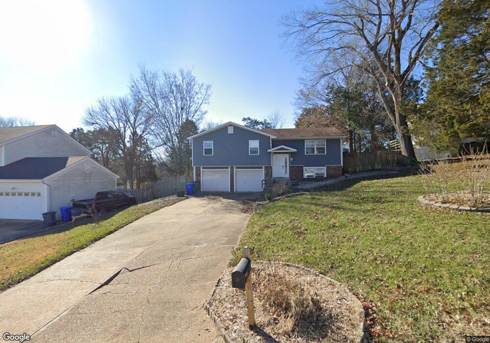
818 Wild Hawk Dr Eureka, MO 63025
Estimated Value: $305,845 - $337,000
3
Beds
3
Baths
1,481
Sq Ft
$217/Sq Ft
Est. Value
About This Home
This home is located at 818 Wild Hawk Dr, Eureka, MO 63025 and is currently estimated at $321,211, approximately $216 per square foot. 818 Wild Hawk Dr is a home located in St. Louis County with nearby schools including Blevins Elementary School, Lasalle Springs Middle School, and Eureka Senior High School.
Ownership History
Date
Name
Owned For
Owner Type
Purchase Details
Closed on
Jul 15, 2008
Sold by
Rmd Investments Inc
Bought by
Mcclintock Properties Llc
Current Estimated Value
Home Financials for this Owner
Home Financials are based on the most recent Mortgage that was taken out on this home.
Original Mortgage
$100,000
Outstanding Balance
$64,578
Interest Rate
6.09%
Mortgage Type
Purchase Money Mortgage
Estimated Equity
$256,633
Purchase Details
Closed on
May 21, 2008
Sold by
Owens David B and Owens Deborah L
Bought by
Rmd Investments Inc
Home Financials for this Owner
Home Financials are based on the most recent Mortgage that was taken out on this home.
Original Mortgage
$100,000
Outstanding Balance
$64,578
Interest Rate
6.09%
Mortgage Type
Purchase Money Mortgage
Estimated Equity
$256,633
Create a Home Valuation Report for This Property
The Home Valuation Report is an in-depth analysis detailing your home's value as well as a comparison with similar homes in the area
Home Values in the Area
Average Home Value in this Area
Purchase History
| Date | Buyer | Sale Price | Title Company |
|---|---|---|---|
| Mcclintock Properties Llc | $125,000 | Ctc | |
| Rmd Investments Inc | $106,750 | Continental Title Company |
Source: Public Records
Mortgage History
| Date | Status | Borrower | Loan Amount |
|---|---|---|---|
| Open | Mcclintock Properties Llc | $100,000 | |
| Previous Owner | Rmd Investments Inc | $110,415 |
Source: Public Records
Tax History
| Year | Tax Paid | Tax Assessment Tax Assessment Total Assessment is a certain percentage of the fair market value that is determined by local assessors to be the total taxable value of land and additions on the property. | Land | Improvement |
|---|---|---|---|---|
| 2025 | $3,592 | $54,190 | $17,730 | $36,460 |
| 2024 | $3,592 | $48,110 | $12,410 | $35,700 |
| 2023 | $3,595 | $48,110 | $12,410 | $35,700 |
| 2022 | $3,363 | $41,880 | $13,300 | $28,580 |
| 2021 | $3,339 | $41,880 | $13,300 | $28,580 |
| 2020 | $3,328 | $39,920 | $10,640 | $29,280 |
| 2019 | $3,338 | $39,920 | $10,640 | $29,280 |
| 2018 | $2,981 | $33,630 | $7,980 | $25,650 |
| 2017 | $2,871 | $33,630 | $7,980 | $25,650 |
| 2016 | $2,655 | $29,900 | $6,210 | $23,690 |
Source: Public Records
Map
Nearby Homes
- 814 Eureka Rd
- 1000 Eureka Rd
- 75 Old Farmhouse Way
- 808 Lower Field Ln
- 826 Lower Field Ln
- 369 Cerny Ave
- 83 Old Farmhouse Way
- 830 Lower Field Ln
- 1075 Eureka Rd
- 329 Kevin Jon Ct
- 318 Kevin Jon Ct
- 331 Artic Fox Ct
- 118 Towne Square Ct Unit D4
- 1045 Bloomfield Dr
- 125 Towne Square Ct Unit 4E
- 1049 Bloomfield Dr
- 1057 Bloomfield Dr
- 2475 Windswept Farms Dr
- 2 Maple Expanded at Windswept
- 2 Hickory at Windswept Farms
- 820 Wild Hawk Dr
- 816 Wild Hawk Dr
- 822 Wild Hawk Dr
- 817 Wild Hawk Dr
- 814 Wild Hawk Dr
- 819 Wild Hawk Dr
- 809 Forest Run Dr
- 821 Wild Hawk Dr
- 824 Wild Hawk Dr
- 823 Wild Hawk Dr
- 812 Wild Hawk Dr
- 116 Hickory Hill Dr
- 810 Forest Run Dr
- 120 Hickory Hill Dr
- 112 Hickory Hill Dr
- 808 Forest Run Dr
- 825 Wild Hawk Dr
- 826 Wild Hawk Dr
- 108 Hickory Hill Dr
- 806 Forest Run Dr
Your Personal Tour Guide
Ask me questions while you tour the home.