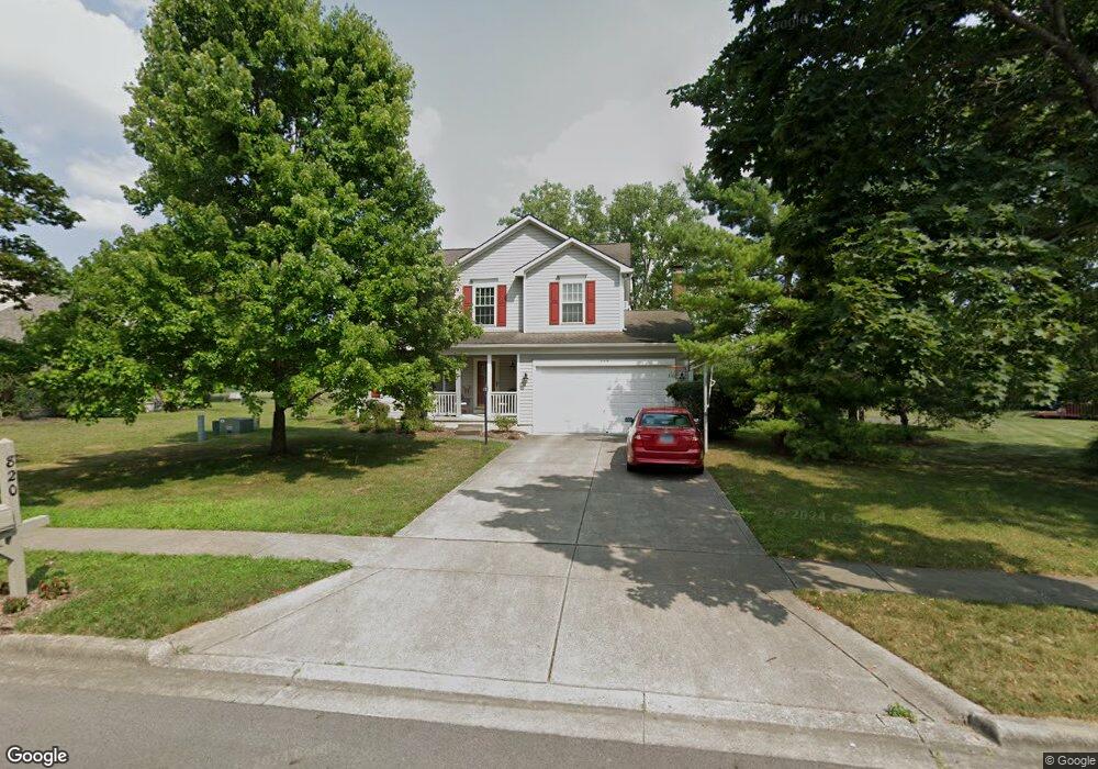
820 McLeod Parc Pickerington, OH 43147
Estimated Value: $421,000 - $431,000
4
Beds
3
Baths
2,370
Sq Ft
$180/Sq Ft
Est. Value
About This Home
This home is located at 820 McLeod Parc, Pickerington, OH 43147 and is currently estimated at $427,107, approximately $180 per square foot. 820 McLeod Parc is a home located in Fairfield County with nearby schools including Violet Elementary School, Pickerington Lakeview Junior High School, and Toll Gate Middle School.
Ownership History
Date
Name
Owned For
Owner Type
Purchase Details
Closed on
Aug 28, 2000
Sold by
Irby Jimmie A
Bought by
Leach Thomas H and Leach Diane S
Current Estimated Value
Home Financials for this Owner
Home Financials are based on the most recent Mortgage that was taken out on this home.
Original Mortgage
$185,600
Interest Rate
8.12%
Mortgage Type
VA
Purchase Details
Closed on
Jul 6, 1995
Sold by
Ryland Group Inc
Bought by
Jimmie A Irby and Goss Jr L Joseph B
Home Financials for this Owner
Home Financials are based on the most recent Mortgage that was taken out on this home.
Original Mortgage
$147,600
Interest Rate
7.9%
Mortgage Type
New Conventional
Purchase Details
Closed on
Mar 16, 1995
Sold by
Raven Dev Co
Bought by
Ryland Group Inc
Create a Home Valuation Report for This Property
The Home Valuation Report is an in-depth analysis detailing your home's value as well as a comparison with similar homes in the area
Home Values in the Area
Average Home Value in this Area
Purchase History
| Date | Buyer | Sale Price | Title Company |
|---|---|---|---|
| Leach Thomas H | $182,000 | -- | |
| Jimmie A Irby | $147,600 | -- | |
| Ryland Group Inc | $26,500 | -- |
Source: Public Records
Mortgage History
| Date | Status | Borrower | Loan Amount |
|---|---|---|---|
| Previous Owner | Leach Thomas H | $185,600 | |
| Previous Owner | Jimmie A Irby | $147,600 |
Source: Public Records
Tax History Compared to Growth
Tax History
| Year | Tax Paid | Tax Assessment Tax Assessment Total Assessment is a certain percentage of the fair market value that is determined by local assessors to be the total taxable value of land and additions on the property. | Land | Improvement |
|---|---|---|---|---|
| 2024 | $13,262 | $107,730 | $18,690 | $89,040 |
| 2023 | $5,079 | $107,730 | $18,690 | $89,040 |
| 2022 | $5,095 | $107,730 | $18,690 | $89,040 |
| 2021 | $4,680 | $84,260 | $17,000 | $67,260 |
| 2020 | $4,644 | $84,260 | $17,000 | $67,260 |
| 2019 | $4,587 | $81,190 | $17,000 | $64,190 |
| 2018 | $4,566 | $70,420 | $17,000 | $53,420 |
| 2017 | $4,579 | $70,550 | $17,130 | $53,420 |
| 2016 | $4,556 | $70,550 | $17,130 | $53,420 |
| 2015 | $4,324 | $63,300 | $14,280 | $49,020 |
| 2014 | $4,271 | $63,300 | $14,280 | $49,020 |
| 2013 | $4,271 | $63,300 | $14,280 | $49,020 |
Source: Public Records
Map
Nearby Homes
- 891 Dunvegan Cir
- 11608 Meadow Ave
- 692 Hill Rd N
- 826 Elgin Cir
- 6448 Bemington Trai
- 1035 Milford Dr
- 9685 Grandview Ave
- 446 Courtland Ln Unit 446
- 12036 Steeplechase Ave NW
- 579 Courtright Dr
- 759 Avebury Dr
- 12008 Sheldrake Ct
- 612 Ludham Trail
- 164 Alexander Lawrence Dr Unit 164
- 111 Jamie Lynn Cir Unit 16
- 12316 Thoroughbred Dr
- 11715 Village Way Dr
- 760 N Starr Dr
- 596 Courtright Dr
- 12052 Peppermill Ln