Estimated Value: $212,000 - $288,000
3
Beds
2
Baths
2,568
Sq Ft
$95/Sq Ft
Est. Value
About This Home
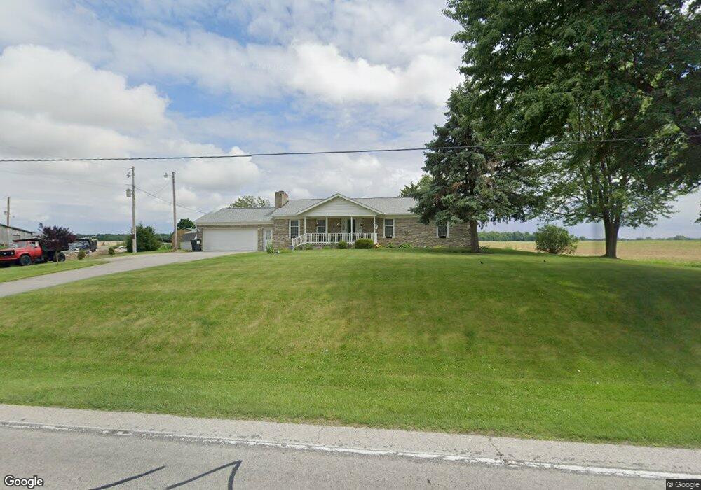
This home is located at 8215 State Route 101 N, Clyde, OH 43410 and is currently estimated at $244,688, approximately $95 per square foot. 8215 State Route 101 N is a home with nearby schools including Clyde High School and Harvest Temple Christian Academy.
Ownership History
Date
Name
Owned For
Owner Type
Purchase Details
Closed on
Nov 17, 2006
Sold by
Jp Morgan Chase Bank
Bought by
West James A and West Donna D
Current Estimated Value
Home Financials for this Owner
Home Financials are based on the most recent Mortgage that was taken out on this home.
Original Mortgage
$68,000
Interest Rate
6.21%
Mortgage Type
New Conventional
Purchase Details
Closed on
Feb 24, 2006
Sold by
Rohrbacher Christopher D and Wagner Jennifer C
Bought by
Jp Morgan Chase Bank
Purchase Details
Closed on
Sep 3, 2004
Sold by
Enderle Gary W
Bought by
Rohrbacher Christopher D
Purchase Details
Closed on
Mar 27, 2001
Sold by
Enderle Gary W
Bought by
Enderle Gary W
Purchase Details
Closed on
Aug 22, 1997
Sold by
Wallace Melva Jean and Wallace Melva J
Bought by
Enderle Gary W
Create a Home Valuation Report for This Property
The Home Valuation Report is an in-depth analysis detailing your home's value as well as a comparison with similar homes in the area
Home Values in the Area
Average Home Value in this Area
Purchase History
| Date | Buyer | Sale Price | Title Company |
|---|---|---|---|
| West James A | $105,000 | None Available | |
| Jp Morgan Chase Bank | $100,000 | None Available | |
| Rohrbacher Christopher D | $155,000 | -- | |
| Enderle Gary W | -- | -- | |
| Enderle Gary W | $92,500 | -- |
Source: Public Records
Mortgage History
| Date | Status | Borrower | Loan Amount |
|---|---|---|---|
| Closed | West James A | $68,000 | |
| Previous Owner | West James A | $65,500 |
Source: Public Records
Tax History Compared to Growth
Tax History
| Year | Tax Paid | Tax Assessment Tax Assessment Total Assessment is a certain percentage of the fair market value that is determined by local assessors to be the total taxable value of land and additions on the property. | Land | Improvement |
|---|---|---|---|---|
| 2024 | $2,333 | $71,590 | $7,530 | $64,060 |
| 2023 | $2,422 | $71,590 | $7,530 | $64,060 |
| 2022 | $1,924 | $53,900 | $7,670 | $46,230 |
| 2021 | $1,939 | $53,900 | $7,670 | $46,230 |
| 2020 | $1,935 | $53,897 | $7,669 | $46,228 |
| 2019 | $1,795 | $51,580 | $7,529 | $44,051 |
| 2018 | $1,791 | $51,580 | $7,529 | $44,051 |
| 2017 | $2,199 | $51,580 | $7,529 | $44,051 |
| 2016 | $2,146 | $50,894 | $6,328 | $44,566 |
| 2015 | $2,112 | $50,894 | $6,328 | $44,566 |
| 2014 | $1,948 | $50,894 | $6,328 | $44,566 |
| 2013 | $2,000 | $50,894 | $6,328 | $44,566 |
Source: Public Records
Map
Nearby Homes
- 0 N Sr 101 Unit 20252008
- 2114 S Main St
- 220 Maple Ln Unit 82
- 104 Ken Lee Dr
- 0 Merlin Ln Unit 20253762
- 0 Merlin Ln Unit 20253639
- 628 W Maple St
- 222 Bertha Ave
- 209 Fair St
- 322 Vine St
- 315 E Grant St
- 235 W Buckeye St
- 167 Excalibur Dr
- 236 Spayd Rd
- 118 E Buckeye St
- 0 Durnwald Dr
- CR 260 89.6 acres Durnwald Dr
- 741 May St
- 1337 E Sr 20
- 117 Nelson St
- 8233 N Tr 179
- 6758 N State Route 18
- 6556 N State Route 18
- 6743 N State Route 18
- 6504 N State Route 18
- 6123 N State Route 18
- 6422 N State Route 18
- 6526 N State Route 18
- 6838 N State Route 18
- 8398 State Route 101 N
- 8211 Township Road 179
- 8585 State Route 101 N
- 8722 County Road 34
- 8054 State Route 101 N
- 10323 E County Road 34
- 8255 State Route 101 N
- 8643 County Road 34
- 8612 County Road 34
- 10413 E Township Road 138
- 4444 County Road 21