Estimated Value: $297,000 - $325,000
4
Beds
2
Baths
1,592
Sq Ft
$196/Sq Ft
Est. Value
About This Home
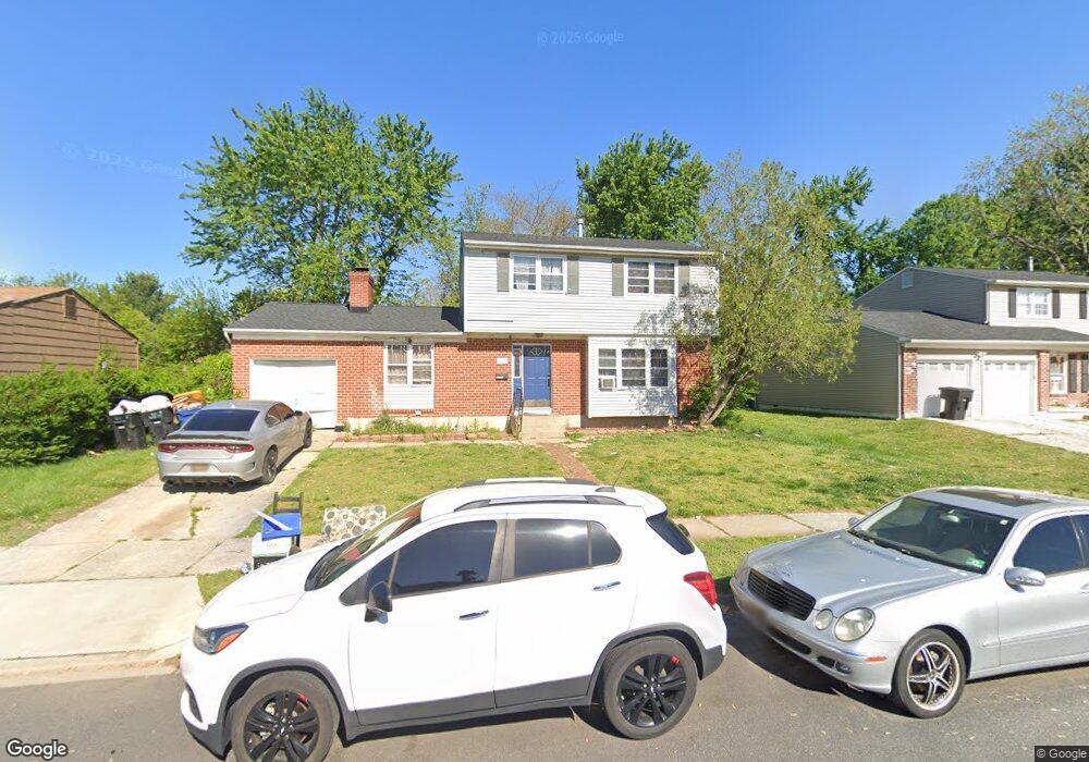
This home is located at 827 Townsend Blvd, Dover, DE 19901 and is currently estimated at $311,855, approximately $195 per square foot. 827 Townsend Blvd is a home located in Kent County with nearby schools including Towne Point Elementary School, William Henry Middle School, and Central Middle School.
Ownership History
Date
Name
Owned For
Owner Type
Purchase Details
Closed on
Mar 7, 2008
Sold by
Brown Michael D
Bought by
Brown Jennifer E
Current Estimated Value
Home Financials for this Owner
Home Financials are based on the most recent Mortgage that was taken out on this home.
Original Mortgage
$207,313
Outstanding Balance
$129,222
Interest Rate
5.75%
Mortgage Type
FHA
Estimated Equity
$182,633
Create a Home Valuation Report for This Property
The Home Valuation Report is an in-depth analysis detailing your home's value as well as a comparison with similar homes in the area
Home Values in the Area
Average Home Value in this Area
Purchase History
| Date | Buyer | Sale Price | Title Company |
|---|---|---|---|
| Brown Jennifer E | -- | None Available |
Source: Public Records
Mortgage History
| Date | Status | Borrower | Loan Amount |
|---|---|---|---|
| Open | Brown Jennifer E | $207,313 |
Source: Public Records
Tax History
| Year | Tax Paid | Tax Assessment Tax Assessment Total Assessment is a certain percentage of the fair market value that is determined by local assessors to be the total taxable value of land and additions on the property. | Land | Improvement |
|---|---|---|---|---|
| 2025 | $1,472 | $250,500 | $93,300 | $157,200 |
| 2024 | $1,422 | $250,500 | $93,300 | $157,200 |
| 2023 | $1,301 | $44,200 | $9,700 | $34,500 |
| 2022 | $1,258 | $44,200 | $9,700 | $34,500 |
| 2021 | $1,212 | $44,200 | $9,700 | $34,500 |
| 2020 | $1,170 | $44,200 | $9,700 | $34,500 |
| 2019 | $1,106 | $44,200 | $9,700 | $34,500 |
| 2018 | $1,010 | $44,200 | $9,700 | $34,500 |
| 2017 | $993 | $44,200 | $0 | $0 |
| 2016 | $997 | $44,200 | $0 | $0 |
| 2015 | $996 | $44,200 | $0 | $0 |
| 2014 | $998 | $44,200 | $0 | $0 |
Source: Public Records
Map
Nearby Homes
- 809 Bacon Ave
- 71 Chatham Ct
- 813 Bacon Ave
- 959 Mcdowell Dr
- 57 Chatham Ct
- 348 W Wind Dr
- 662 Vista Ave
- 668 Vista Ave
- 40 Anchor Ln
- 53 Washington St
- 108 N Halsey Rd
- 31 Washington St
- 118 Beth Place
- 630 Maple Pkwy
- 196 Willis Rd
- 328 N Bradford St
- 137 Beth Place
- 135 Maureen Place
- 33 Spruance Rd
- 224 N State St
- 823 Townsend Blvd
- 831 Townsend Blvd
- 738 Miller Dr
- 819 Townsend Blvd
- 730 Miller Dr
- 835 Townsend Blvd
- 744 Miller Dr
- 724 Miller Dr
- 815 Townsend Blvd
- 828 Townsend Blvd
- 832 Townsend Blvd
- 824 Townsend Blvd
- 839 Townsend Blvd
- 836 Townsend Blvd
- 820 Townsend Blvd
- 718 Miller Dr
- 811 Townsend Blvd
- 756 Miller Dr
- 840 Townsend Blvd
- 735 Miller Dr
Your Personal Tour Guide
Ask me questions while you tour the home.