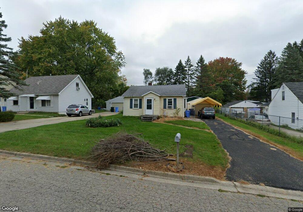
836 Hein Ave Lansing, MI 48911
Southern Lansing NeighborhoodEstimated Value: $90,000 - $117,000
2
Beds
1
Bath
1,144
Sq Ft
$89/Sq Ft
Est. Value
About This Home
This home is located at 836 Hein Ave, Lansing, MI 48911 and is currently estimated at $102,110, approximately $89 per square foot. 836 Hein Ave is a home located in Ingham County with nearby schools including Reo Elementary School, Attwood School, and Everett High School.
Ownership History
Date
Name
Owned For
Owner Type
Purchase Details
Closed on
Apr 1, 2021
Sold by
Kinnison Mark J
Bought by
Isles Jay and Isles Lucy
Current Estimated Value
Purchase Details
Closed on
May 29, 2003
Sold by
Willett Thomas
Bought by
Kinnison Mark J
Home Financials for this Owner
Home Financials are based on the most recent Mortgage that was taken out on this home.
Original Mortgage
$61,200
Interest Rate
5.51%
Mortgage Type
VA
Purchase Details
Closed on
Jul 28, 1998
Sold by
Keep Lynn and Keep Linda
Bought by
Willett Thomas A
Purchase Details
Closed on
Mar 28, 1997
Sold by
Harris Daniel C and Harris Judy M
Bought by
Keep Lynn and Keep Linda
Create a Home Valuation Report for This Property
The Home Valuation Report is an in-depth analysis detailing your home's value as well as a comparison with similar homes in the area
Home Values in the Area
Average Home Value in this Area
Purchase History
| Date | Buyer | Sale Price | Title Company |
|---|---|---|---|
| Isles Jay | -- | None Available | |
| Kinnison Mark J | $60,000 | Midstate Title Co | |
| Willett Thomas A | $59,900 | -- | |
| Keep Lynn | $46,900 | -- |
Source: Public Records
Mortgage History
| Date | Status | Borrower | Loan Amount |
|---|---|---|---|
| Closed | Kinnison Mark J | $61,200 |
Source: Public Records
Tax History Compared to Growth
Tax History
| Year | Tax Paid | Tax Assessment Tax Assessment Total Assessment is a certain percentage of the fair market value that is determined by local assessors to be the total taxable value of land and additions on the property. | Land | Improvement |
|---|---|---|---|---|
| 2025 | $2,027 | $41,700 | $7,600 | $34,100 |
| 2024 | $16 | $35,700 | $7,600 | $28,100 |
| 2023 | $1,909 | $31,800 | $7,600 | $24,200 |
| 2022 | $1,746 | $28,000 | $7,600 | $20,400 |
| 2021 | $1,705 | $25,800 | $5,500 | $20,300 |
| 2020 | $1,693 | $23,000 | $5,500 | $17,500 |
| 2019 | $1,634 | $22,000 | $5,500 | $16,500 |
| 2018 | $1,551 | $19,700 | $5,500 | $14,200 |
| 2017 | $1,492 | $19,700 | $5,500 | $14,200 |
| 2016 | $1,139 | $19,400 | $5,500 | $13,900 |
| 2015 | $1,139 | $18,900 | $11,023 | $7,877 |
| 2014 | $1,139 | $19,400 | $16,534 | $2,866 |
Source: Public Records
Map
Nearby Homes
- 1020 R G Curtiss Ave
- 1119 W Miller Rd
- 5902 Hilliard Rd
- 1014 W Northrup St
- 6270 S Washington Ave
- 5750 Ashley Dr
- 6029 Ellendale Dr
- 6037 Hughes Rd
- 5636 Ellendale Dr
- 218 Raritan Rd
- 6421 S Washington Ave
- 825 Ferley St
- 5727 Annapolis Dr
- 129 Village Dr
- 6444 Sommerset Rd
- 5730 Laporte Dr
- 5838 S Martin Luther King Junior Blvd
- 208 E Northrup St
- 6429 Rosedale Rd
- 0 W Jolly Rd
- 900 Hein Ave
- 828 Hein Ave
- 908 Hein Ave
- 837 R G Curtiss Ave
- 901 R G Curtiss Ave
- 831 R G Curtiss Ave
- 913 R G Curtiss Ave
- 916 Hein Ave
- 820 Hein Ave
- 901 R G Curtiss Ave
- 833 Hein Ave
- 825 R G Curtiss Ave
- 901 R G Curtis Ave
- 825 Hein Ave
- 917 R G Curtiss Ave
- 823 Hein Ave
- 911 Hein Ave
- 920 Hein Ave
- 817 R G Curtiss Ave
- 923 R G Curtiss Ave