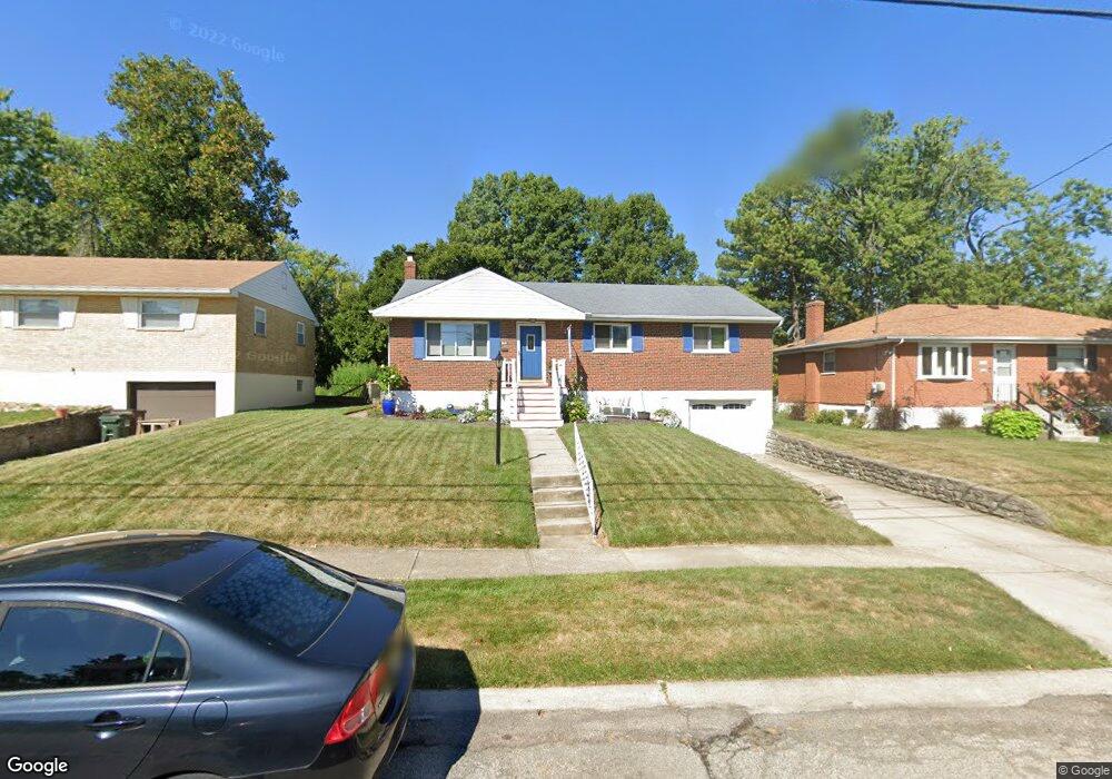
8441 Mockingbird Ln Cincinnati, OH 45231
Finneytown NeighborhoodEstimated Value: $219,000 - $246,000
3
Beds
2
Baths
1,688
Sq Ft
$139/Sq Ft
Est. Value
About This Home
This home is located at 8441 Mockingbird Ln, Cincinnati, OH 45231 and is currently estimated at $234,299, approximately $138 per square foot. 8441 Mockingbird Ln is a home located in Hamilton County with nearby schools including Finneytown Elementary School, Finneytown Secondary Campus, and St. Vivian School.
Ownership History
Date
Name
Owned For
Owner Type
Purchase Details
Closed on
Nov 21, 2000
Sold by
Goldschmidt Michael K
Bought by
Cummings Randall K and Cummings Minerva S
Current Estimated Value
Home Financials for this Owner
Home Financials are based on the most recent Mortgage that was taken out on this home.
Original Mortgage
$107,397
Interest Rate
7.86%
Mortgage Type
FHA
Purchase Details
Closed on
Mar 30, 2000
Sold by
Heinrich Goldschmidt
Bought by
Goldschmidt Michael K
Home Financials for this Owner
Home Financials are based on the most recent Mortgage that was taken out on this home.
Original Mortgage
$64,000
Interest Rate
8.31%
Mortgage Type
Balloon
Create a Home Valuation Report for This Property
The Home Valuation Report is an in-depth analysis detailing your home's value as well as a comparison with similar homes in the area
Home Values in the Area
Average Home Value in this Area
Purchase History
| Date | Buyer | Sale Price | Title Company |
|---|---|---|---|
| Cummings Randall K | $108,000 | -- | |
| Goldschmidt Michael K | $80,000 | Tri-Star Title Agency Inc |
Source: Public Records
Mortgage History
| Date | Status | Borrower | Loan Amount |
|---|---|---|---|
| Closed | Cummings Randall K | $107,397 | |
| Closed | Goldschmidt Michael K | $64,000 |
Source: Public Records
Tax History
| Year | Tax Paid | Tax Assessment Tax Assessment Total Assessment is a certain percentage of the fair market value that is determined by local assessors to be the total taxable value of land and additions on the property. | Land | Improvement |
|---|---|---|---|---|
| 2025 | $4,038 | $57,481 | $12,040 | $45,441 |
| 2024 | $3,922 | $57,481 | $12,040 | $45,441 |
| 2023 | $3,856 | $57,481 | $12,040 | $45,441 |
| 2022 | $3,475 | $37,562 | $9,471 | $28,091 |
| 2021 | $3,409 | $37,562 | $9,471 | $28,091 |
| 2020 | $3,465 | $37,562 | $9,471 | $28,091 |
| 2019 | $3,183 | $31,833 | $8,026 | $23,807 |
| 2018 | $2,939 | $31,833 | $8,026 | $23,807 |
| 2017 | $2,801 | $31,833 | $8,026 | $23,807 |
| 2016 | $2,712 | $30,286 | $8,068 | $22,218 |
| 2015 | $2,729 | $30,286 | $8,068 | $22,218 |
| 2014 | $2,731 | $30,286 | $8,068 | $22,218 |
| 2013 | $2,695 | $30,905 | $8,232 | $22,673 |
Source: Public Records
Map
Nearby Homes
- 1006 Hearthstone Dr
- 1055 Hempstead Dr
- 8628 Mockingbird Ln
- 1144 Hempstead Dr
- 1052 Vacationland Dr
- 1165 W Galbraith Rd
- 1116 Madeleine Cir
- 8609 Balboa Dr
- 8829 Mockingbird Ln
- 958 Hollytree Dr
- 1297 Landis Ln
- 6666 Orleans Ct
- 6669 Kirkland Dr
- 1101 Meadowind Ct
- 838 W Galbraith Rd
- 8719 Hood Ct
- 833 W Galbraith Rd
- 8943 Monsanto Dr
- 7923 Bobolink Dr
- 816 Sabino Ct
- 8449 Mockingbird Ln
- 8433 Mockingbird Ln
- 8425 Mockingbird Ln
- 1017 Pinehollow Ln
- 1013 Pinehollow Ln
- 1021 Pinehollow Ln
- 8446 Mockingbird Ln
- 8438 Mockingbird Ln
- 8465 Mockingbird Ln
- 1009 Pinehollow Ln
- 8417 Mockingbird Ln
- 8452 Mockingbird Ln
- 1025 Pinehollow Ln
- 1071 Pelican Dr
- 1069 Thunderhill Dr
- 1069 Thunderbird Ave
- 8409 Mockingbird Ln
- 8473 Mockingbird Ln
- 1064 Pelican Dr
- 1005 Pinehollow Ln
Your Personal Tour Guide
Ask me questions while you tour the home.