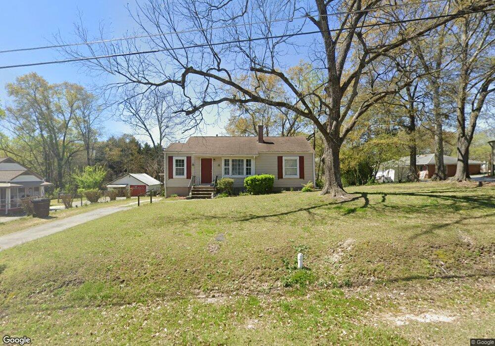
8443 Duncan St Douglasville, GA 30134
Estimated Value: $152,821 - $206,000
2
Beds
1
Bath
995
Sq Ft
$173/Sq Ft
Est. Value
About This Home
This home is located at 8443 Duncan St, Douglasville, GA 30134 and is currently estimated at $172,455, approximately $173 per square foot. 8443 Duncan St is a home located in Douglas County with nearby schools including Burnett Elementary School, Chestnut Log Middle School, and Douglas County High School.
Ownership History
Date
Name
Owned For
Owner Type
Purchase Details
Closed on
Feb 11, 2015
Sold by
Vick Jeffery A
Bought by
Duncan Street Llc
Current Estimated Value
Purchase Details
Closed on
Jul 1, 2000
Sold by
Broadwell M Claire
Bought by
Vick Jeffrey A and Vick Leslie G
Home Financials for this Owner
Home Financials are based on the most recent Mortgage that was taken out on this home.
Original Mortgage
$45,000
Interest Rate
8.23%
Mortgage Type
New Conventional
Create a Home Valuation Report for This Property
The Home Valuation Report is an in-depth analysis detailing your home's value as well as a comparison with similar homes in the area
Home Values in the Area
Average Home Value in this Area
Purchase History
| Date | Buyer | Sale Price | Title Company |
|---|---|---|---|
| Duncan Street Llc | -- | -- | |
| Vick Jeffrey A | $45,000 | -- |
Source: Public Records
Mortgage History
| Date | Status | Borrower | Loan Amount |
|---|---|---|---|
| Previous Owner | Vick Jeffrey A | $45,000 |
Source: Public Records
Tax History Compared to Growth
Tax History
| Year | Tax Paid | Tax Assessment Tax Assessment Total Assessment is a certain percentage of the fair market value that is determined by local assessors to be the total taxable value of land and additions on the property. | Land | Improvement |
|---|---|---|---|---|
| 2024 | $2,013 | $48,440 | $27,200 | $21,240 |
| 2023 | $2,013 | $45,880 | $25,600 | $20,280 |
| 2022 | $1,481 | $36,500 | $16,000 | $20,500 |
| 2021 | $1,264 | $31,036 | $16,000 | $15,036 |
| 2020 | $1,288 | $31,036 | $16,000 | $15,036 |
| 2019 | $1,205 | $30,664 | $16,000 | $14,664 |
| 2018 | $1,189 | $30,052 | $16,000 | $14,052 |
| 2017 | $1,091 | $27,284 | $15,360 | $11,924 |
| 2016 | $1,087 | $26,712 | $15,360 | $11,352 |
| 2015 | $1,116 | $26,632 | $15,520 | $11,112 |
| 2014 | $1,019 | $24,816 | $15,040 | $9,776 |
| 2013 | -- | $26,392 | $16,000 | $10,392 |
Source: Public Records
Map
Nearby Homes
- 8546 Adair St
- 8523 Duncan St
- 6419 Katherine St
- 8612 Campbellton St
- 8693 Ashley Way
- 8676 Ashley Way
- 6648 Ridge Ave
- 8692 Ashley Way
- 8694 Ashley Way
- 6253 Hospital Way
- 6787 W Strickland St
- 8738 Campbellton St
- 8541 Westchester Dr
- 8538 Westchester Dr
- 6214 Hagin St
- 8090 Colquitt St
- 8068 Greene Ct
- 6339 Cornelia Dr
- 8451 Duncan St
- 8461 Duncan St
- 8436 Duncan St
- 8442 Duncan St
- 6554 Spring St
- 8454 Duncan St
- 8421 Duncan St
- 8419 Duncan St
- 6498 Spring St
- 6543 Spring St
- 6549 Katherine St
- 8417 Duncan St
- 6477 Katherine St
- 8415 Duncan St
- 8411 Duncan St
- 6519 Spring St
- 6519 Spring St Unit 1
- 8479 Duncan St
- 8409 Duncan St
- 8432 Adair St