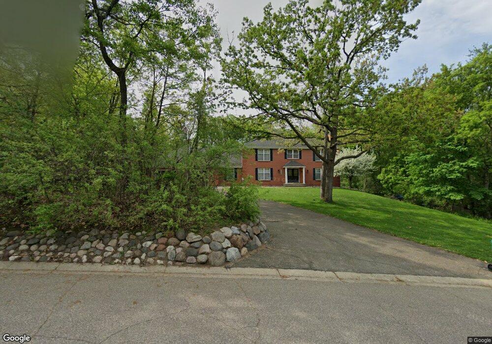
8492 133rd St W Saint Paul, MN 55124
Alimagnet NeighborhoodEstimated Value: $689,085 - $740,000
4
Beds
4
Baths
3,113
Sq Ft
$227/Sq Ft
Est. Value
About This Home
This home is located at 8492 133rd St W, Saint Paul, MN 55124 and is currently estimated at $707,771, approximately $227 per square foot. 8492 133rd St W is a home located in Dakota County with nearby schools including Echo Park Elementary School of Leadership, Engineering & Technology, Falcon Ridge Middle School, and Apple Valley Senior High School.
Ownership History
Date
Name
Owned For
Owner Type
Purchase Details
Closed on
Apr 1, 2020
Sold by
Wallin Lloyd A and Wallin Darlene F
Bought by
Polson Sonda and Polson Jack
Current Estimated Value
Home Financials for this Owner
Home Financials are based on the most recent Mortgage that was taken out on this home.
Original Mortgage
$424,000
Outstanding Balance
$374,179
Interest Rate
3.2%
Mortgage Type
New Conventional
Estimated Equity
$333,592
Create a Home Valuation Report for This Property
The Home Valuation Report is an in-depth analysis detailing your home's value as well as a comparison with similar homes in the area
Home Values in the Area
Average Home Value in this Area
Purchase History
| Date | Buyer | Sale Price | Title Company |
|---|---|---|---|
| Polson Sonda | $530,000 | Premier Title |
Source: Public Records
Mortgage History
| Date | Status | Borrower | Loan Amount |
|---|---|---|---|
| Open | Polson Sonda | $424,000 |
Source: Public Records
Tax History Compared to Growth
Tax History
| Year | Tax Paid | Tax Assessment Tax Assessment Total Assessment is a certain percentage of the fair market value that is determined by local assessors to be the total taxable value of land and additions on the property. | Land | Improvement |
|---|---|---|---|---|
| 2024 | $7,748 | $659,900 | $181,500 | $478,400 |
| 2023 | $7,748 | $654,800 | $181,800 | $473,000 |
| 2022 | $6,260 | $623,400 | $181,300 | $442,100 |
| 2021 | $6,010 | $531,800 | $157,600 | $374,200 |
| 2020 | $6,098 | $503,900 | $150,100 | $353,800 |
| 2019 | $5,429 | $496,500 | $143,000 | $353,500 |
| 2018 | $5,519 | $461,200 | $136,100 | $325,100 |
| 2017 | $5,761 | $447,900 | $129,700 | $318,200 |
| 2016 | $5,454 | $442,900 | $123,500 | $319,400 |
| 2015 | $5,776 | $414,200 | $121,100 | $293,100 |
| 2014 | -- | $441,800 | $116,700 | $325,100 |
| 2013 | -- | $424,300 | $107,900 | $316,400 |
Source: Public Records
Map
Nearby Homes
- 13345 Huntington Cir
- 13101 Heritage Way
- 13306 Huntington Cir
- 13749 Heywood Ct
- 13751 Hollybrook Cir
- 13591 Hollybrook Way
- 13599 Hollybrook Dr
- 13731 Hollybrook Cir
- 13609 Hollybrook Dr
- 13727 Hollybrook Cir
- 13420 Gull Ct
- 13613 Hollybrook Dr
- The Sophia Plan at Eagle Pointe - Townhomes
- The Amelia Plan at Eagle Pointe - Townhomes
- The Magnolia Plan at Eagle Pointe - Townhomes
- The Nolan Plan at Eagle Pointe - Townhomes
- 13761 Hollybrook Cir
- 13820 Holyoke Path
- 14132 Heywood Path
- 110 Pony Ln E
- 8488 133rd St W
- 8496 133rd St W
- 8489 133rd St W
- 8500 133rd St W
- 8484 133rd St W
- 8295 Havelock Ct
- 8493 133rd St W
- 8290 Havelock Ct
- 8497 133rd St W
- 8480 133rd St W
- 8501 133rd St W
- 8275 Havelock Ct
- 8391 134th Street Ct
- 8481 133rd St W
- 8481 133rd St W
- 8270 Havelock Ct
- 8409 134th Street Ct
- 8429 134th Street Ct
- 8445 134th Street Ct
- 13375 Havelock Trail